Dawn to Dusk Ride – Exploring the La Chaine de Belledonne
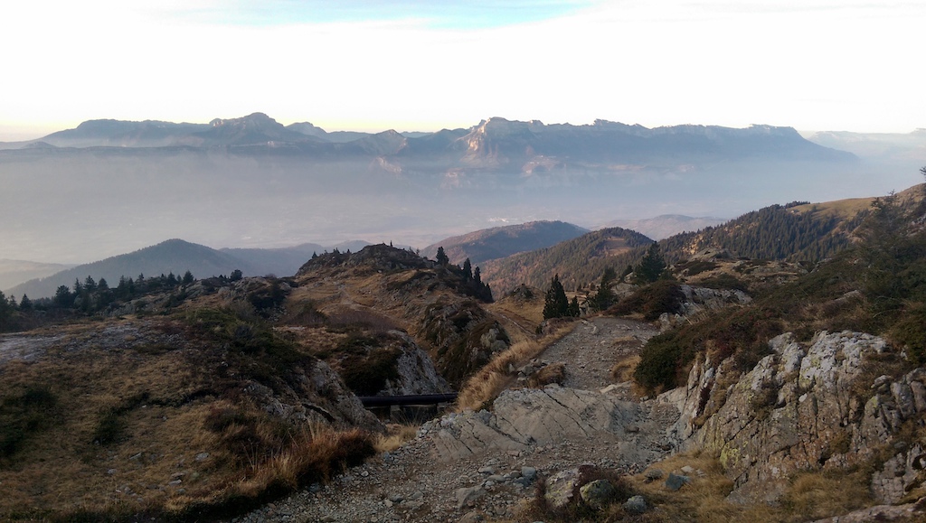
I made the decision recently to go and explore the La Chaine de Belledonne, which is the mountain range to the southwest of Grenoble, France where I live - it has peaks that rise above 3000m and to me, looked like a proper ‘alpine’ mountain range. Until now I hadn't really ventured into this mountain range before, given that it takes a lot longer to get there on the road before the actual trails start and that the snow seems to stay on the slopes, especially those visible from the city as they are mostly north facing.
![The sun rising behind the peaks I was off to explore as I left the city]()
So back in November, partially inspired by this story on Pinkbike about riding during the sun rise I decided to take the whole day and try and reach the Croix de Belledonne at 2926m, leaving the house at sunrise and returning at sunset and effectively riding dawn to dusk. I could see from my balcony that the recent 'second summer' we were having here meant that most of the peaks were completely free from snow, but the Croix was further back behind the first peaks so I wasn't sure what to expect in terms of snow and ice, but then that was all part of the adventure. If anyone would like to have a crack at the route themselves then you can find a GPD trace here.
![Stopping for a quick break to take in the view across the valley towards Le Chartreuse where the sun was already shining. The road was pretty relentless about 30km in all I remember doing it on my road bike two years ago but didn t remember it being so long]()
I really love the idea of going on a proper adventure with my bike. I think it might be why I prefer natural trails to bike parks and going out into the unknown and exploring some new trails, potentially getting a little lost, taking on some rugged terrain or difficult trails and if that involves summiting a mountain along the way, well, that's just even better. So I was pretty excited to go explore some real alpine terrain high up above 2000m and potentially summit the Croix de Belldonne at almost 3000m… And in mid November, which is crazy on a bike!
I think I ended up being so excited that I didn't actually get much sleep the night before. I prepared all my kit, made my sandwiches, prepared my stove and Mokka, packed my bag the night before and even spent half an hour trying to sand my new brake pads so they worked better, so that all I had to do was wake up in the morning, grab a coffee and some breakfast, brush my teeth, a quick cautionary visit to the toilet and hop on my bike!
![Preparation the night before. Amazingly all of the stuff on the table was either warm or fit into my tiny Dakine bag]()
A large amount of the morning was spent cycling out from the city and up the road that leaves Uriage-Les-Bains down in the damp valley and up to the ski centre of Chamrousse, which sits rather proudly above the tree line of Belledonne. My cold feet slowly thawed as the sun began to appear over the top of the ridge - when it finally did I started to wake. Before I even reached the first section of trail I noticed I had already done 30km on the road and after a long and gradual climb up, it was straight into a nice and steep hike-a-bike.
![After about an hour of climbing I finally came into the first bit of direct sunlight to warm my hands and feet up]()
![The road climb had taken me up to 1400m so it didn t take long on the hike-a-bike to get up above the clouds]()
![Next leg of the hike-a-bike was a rather rugged trail with some pretty huge rocks and steps it didn t look rideable down never mind up.]()
![A quick pause for a food break. The trail wound its way up through the rocks to the right of this stack if you look hard enough you might spot the guys that were out climbing up there I guess they were out super early to be up there climbing before me]()
The road climb had taken me up to around 1400m, but the hike-a-bike took me right up into proper alpine territory, up above the clouds and up above the tree line. The first section of the climb was up through the pine trees, which looked like it would be a real good trail to take one day. I headed on through big rock gardens and along side waterfalls, and up paths strewn with pine needles. At the top of this I met a group of eldery ‘ramblers’ out on the trail who thought I certainly shouldn’t be on trails like these with my bike and that ‘there was no way it was possible to ride’ and it ‘just wasn’t worth taking the bike over these hills’, safe to say I am glad I politely disagreed...
![By this height it had started to become more rocky than wooded. The views started to open up the ridge in the distance is the first mountains of Le Vercors including Le Pic Saint Michel and La Moucherotte which I have been up a few times previously]()
![Just as my back was starting to get pretty sort I finally arrived at the first plateau at 2000m and was able to ride my bike for the first time in about an hour and a half]()
By the top of the climb I was standing at 2000m and was pretty happy to be looking across to some big rocky faces and rugged mountain sides, I was however quite surprised to see a ski lift on the other side of the little lake - it turns out that the ski slopes of the Chamrousse ski resort reached this far.
![By now the terrain was certainly alpine very little trees with a very rocky outlook this is what I came for. I could see on the map I had to head towards and through the dark patch of trees straight ahead now how do I get there]()
After the huge climb I was finally greeted with my first little piece of rideable single track, which I have to say, felt great to be riding in this kind of setting. As I then rounded the corner, I was immediately greeted with total 'mountain overload' with ridges and valleys extending into the distance for miles, it took me a good while to understand the reality compared to the map and where my path was actually supposed to take me and just how far across this boulder field I had to ride. When things finally clicked I managed to spot a slither of grey trail hugging the side of some rocky outcrops - to get there involved negotiating a rather steep and rocky descent.
![By the time I reached the trees in the previous photo the terrain heading back down towards the city had gotten pretty steep it felt like the clouds were right below me]()
![The trail however was more questionable any ideas]()
On the map to get from the top of the first proper hike a bike to the refuge de la Pra (before I ascended up to the Croix) it looked quite far and sure enough it was quite far - it did not however look like I gained or lost that much elevation, in the end though there was quite a lot of ups and downs. The ups being almost always a hike-a-bike as the ground was just too rugged to try and push, and the only decent down was through what felt more like a rock slide than a path (photo above). I finally made it all the way across to the refuge though with the last section being really good fun to ride along the side of a rather dried up looking lake, which was no surprise given the tiny amount of rain we've had recently.
![Finally closing in on the plateau where the Refuge de la Pra is back up at 2000m the light yellow patch at the back of the scene]()
![Looking back down the valley towards Pic st. Michel away in the distance I think the two guys in the photo were a bit surprised to see me on my bike up here just like most people were to be honest]()
![Lunch spot You can see the refuge in the back of the plateau it was quite unusual to find this almost perfectly flat plateau after travelling across such rough terrain to get here a little bit of tranquility between the jagged landscape]()
![The view from the lunch stop at the refuge I love a good coffee from the Mokka so I decided to bring my stove and make myself a coffee at 2000m up in the mountains I think the neighbouring picnicers were a little jealous]()
The lunch stop came as a welcome relief as my legs were feeling quite tired by this point and I was struggling to cycle across the flat ground of the plateau to reach the refuge. I had come prepared for today, realising I needed a lot of food. I was very happy at the chance to be able to take my little stove and fire up a coffee in the Moka - there was even a glass left behind in the part of the refuge that is left open for the winter, which I was able to use since I had forgotten my mug!
Now… for the most exciting part, how high would I make it up to the Croix de Belledonne, there was already some snow on the north faces around the refuge but not a lot, so maybe it was still possible.
I set off on the path up above with refuge with a quick look down the Col de la Pra (that I would be taking later) it filled me with excitement… And oh my, it looked good! Of course, you guessed it, it was more hike-a-bike, but by now I had become pretty used to it and had worked that if I attached the belt and chest straps on my bag, then my shoulder didn’t really hurt anymore whilst carrying the bike - I mean I couldn’t breathe as well, but I decided that was better than my shoulder hurting.
![After lunch this is what I was looking at it seemed to get even steeper and even more rugged rather spectacular scenery the trail headed up the left hand side of the waterfall]()
![Once I got up past the two Lacs Du Dom non this was the view I was faced with. It looked like top was in sight the trail I was supposed to take is up on the right where the snow is lying I thought I would go up as far as possible at least but it was clear the path all the way to the top was not going to be possible]()
![Luckily there was one other guy at the highest point I went to he kindly obliged to take my photo not sure he was too warm in his skimpy shorts up at this altitude though]()
Once I reached the next plateau it felt like the terrain got yet more wild and rugged, I guess maybe the introduction of the snow helped with that and maybe also that the rocks were a sort of red colour in places - it felt like I was in South America or somewhere, not just hours from my house. I felt like I had climbed for ever and yet the peaks still grew higher around me. I would have loved to continue climbing but a combination of snow, the sun getting lower and me running out of energy meant that it looked like reaching the summit was not possible, but I like to feel like I have achieved some kind of ‘goal’ so I set myself a target of climbing to 2500m before stopping for a rest to take in the breathtaking scenery before heading back down... I sat in the warm sun for 5 or 10 minutes to enjoy the views and smile about the fact that I had a 2300m descent ahead of me, perfect.
![This is where the trail headed if you look closely you might see some footprints from people earlier in the day but they had ascended when the snow was soft by now it was frozen again and way too slippy to walk up as one guy I saw proved when he attempted to climb up and made it only 50m or so before very carefully shuffling back down]()
![Looking back down the valley from the highest point and it looked positively warm summery even you wouldn t believe it was November 14th at 2500m altitude]()
![I could have gone higher up this path which wasn t marked on the map to the top of the col but I decided at this point that I was pretty tired out so decided that a new goal of reaching 2500m was enough and I wanted to keep a bit of energy for the mega descent so I at least had a little control over my bike rather than just being a passenger on the way down]()
![The Mondraker looking rather majestic at 2500m I had to wonder how many other people have had their bike up here]()
![The effect the ice gave on the frozen lake was quite unusual]()
![Looking down the valley from just above the waterfall seen earlier in the ride]()
![The first section of the trail from the 2500m mark to the waterfall was all rideable quite easy going in terms of gradient but fairly technical in places even the snow ice on the trail next to the lakes was rideable. At the waterfall there was a section that had to be walked but nearer the bottom you can see the trail to the bottom right which was rideable. The two women I met down there were a little surprised I was riding up here]()
The first section of the trail from the 2500m mark to the waterfall was all rideable and quite easy going in terms of gradient, but still fairly technical in places, even the snow/ice on the trail next to the lakes was rideable. At the waterfall there was a section that had to be walked, but nearer the bottom you can see the trail to the bottom right which was rideable. The two women I met further down were a little surprised I was riding up here!
As is almost always the case, a lot more of the trail was rideable compared to how it looked on the way up. I had passed various groups of people on the way up and had asked a lot about what the snow was like higher up, they were all pretty interested or excited to see me come down again, or maybe mostly bewildered to see a mountain biker up so high.
The trail was certainly rocky and very technical, but it is exactly how I like it - I love it if parts of the trail are simply a challenge just to ride down and then the parts that are too difficult to ride down always leave me thinking ‘if only I was Danny Macaskill, I would totally have ridden that’.
![Down below here is the top of the Col de la Pra where I had lunch and where I had started my ascent up to the Croix de Belledonne. The refuge plateau over to the left where I had come from earlier and the trail I was to descent away down the valley to the right all of this section was rideable with a few corners requiring endo-turns however]()
Down below here is the top of the Col de la Pra where I had lunch and where I had started my ascent up to the Croix de Belledonne. The refuge plateau over to the left where I had come from earlier and the trail I was to descent away down the valley to the right all of this section was rideable with a few corners requiring endo-turns however
![From the top of the Col de la Pra you can see all the way out past Le Lac du Crozet to Le Dent de Crolles et La Chartreuse. The first part of this section is a bunch of really rocky and loose switchbacks with the trail heading along the right hand side of the lake this section is fantastic and is was all rideable there are several pretty technical little sections which are all rideable with a little bit of momentum and determination]()
From the top of the Col de la Pra you can see all the way out past Le Lac du Crozet to Le Dent de Crolles et La Chartreuse. The first part of this section is a bunch of really rocky and loose switchbacks with the trail heading along the right hand side of the lake, this section is fantastic and was all rideable - there are several pretty technical sections, which are all rideable with a little bit of momentum and determination
The trail from the top of the Col de la Pra certainly goes into my books as one of the best I have ever ridden (I seem to say that quite often…) with all sorts of terrain from drifty corners, to tight switchbacks, big rocks slabs and steep technical sections along with the fact that you were riding down an incredibly scenic and intimidating valley made it quite the epic descent that I was hoping for.
![This was the smiles that the section of trail along side the lakes brought Super excited whilst riding this]()
![The trail along side the lake is pretty well defined and could even be said to have a bit of flow at some point sometimes mostly technical though pretty technical]()
![The next section of the trail after the lake was probably the hardest BUT probably the best There are a series of corners switchbacks which have a lot of rocky features steps and drops which provide some pretty good challenges the trail is pretty loose but with some larger rock slabs now and then which is just what I love for those reading this in the UK I would compare it to some of the best trails in the lake district very rocky very technical and with some very challenging sections]()
The next section of the trail after the lake was probably the hardest, BUT probably the best! There are a series of corners/switchbacks which have a lot of rocky features, steps and drops which provide some pretty good challenges, the trail is pretty loose, but with some larger rock slabs now and then, which is just what I love. For those reading this in the UK, I would compare it to some of the best trails in the Lake District, so very rocky, very technical and with some very challenging sections.
I would certainly recommend this trail to anyone who loves ‘technical’ riding, as it was a pure tech-fest! I will definitely be back to do it again. The switchbacks above the lake, the almost ‘flowy’ sections along side the lake, the big rock slabs below the lake, the awkward boulders above the treeline and the fast switch backs in the trees made it oh so good. Oh, and did I mention once you get to the car park down in the trees, you cut straight across it and take the line which looks like it is from the top of a jump, which is a downhill track constructed by the local lads filled with berms, drops, doubles and you name it. So if you still have the energy and your arms haven’t turned to jelly by this point then you are in for a treat!
![Looking back up the trail from below Le Lac du Crozet you can just make out a group of students lost amongst the wall of rocks who I passed who were on the way up to Le Refuge de la Pra for the night]()
![Looking back up to the mountains I had travelled across earlier from Revel a village in the foothills of Belledonne]()
![Dusk was certainly on its way by the time I exited from the forest and onto the road back to the bottom of the valley]()
![While cycling along the road back into the city the setting sun light up the clouds in a rather strong shade of pink]()
I set out with the idea to ride from sunrise to sunset and with the simple goal of exploring some trail, a little unsure of what I would find along the way. I ended up on what felt like a true alpine epic, a real adventure into the mountains through some amazing scenery on some incredible trails, and even though I set off for the day on my own I ended up spending most of the day with people, interested in what I was doing, this is a part of riding in ‘hike-a-bike’ type locations that I always forget about and that I really like, nobody ever seems annoyed or grumpy that you are there. Everyone's friends in the mountains. This is exactly the kind of adventure I moved to the Alps looking for. Until next time...
If anyone is interested in hearing more stories of a similar nature, head over to Any Excuse to Ride and my Facebook page.
So who is William Gibson: I'm originally from a small village in rural Northumberland in the UK, but currently live in Grenoble, France and have had the opportunity to live in a number of places over the years. Studying and working in architecture has allowed me to spend time in Scotland, London, Slovenia and Norway amongst others, but I've always chosen places with a good location for mountain biking, except for London of course...
I've certainly developed a love for adventuring on my bike - ask any of my friends - and I'm always the one exploring the map. I don't really like going to session the same track all day. I would rather go and get lost in the mountains all day and not come back until it gets dark. With Grenoble sitting at 200m above sea levels and peaks rising to 2/3000m dominating the city, I think there is plenty of opportunity for that, as demonstrated in the story. I hope you enjoyed it as much as I did?
MENTIONS: @anyexcusetoride

Leaving the city with the sun rising behind the peaks... I was off to explore!
So back in November, partially inspired by this story on Pinkbike about riding during the sun rise I decided to take the whole day and try and reach the Croix de Belledonne at 2926m, leaving the house at sunrise and returning at sunset and effectively riding dawn to dusk. I could see from my balcony that the recent 'second summer' we were having here meant that most of the peaks were completely free from snow, but the Croix was further back behind the first peaks so I wasn't sure what to expect in terms of snow and ice, but then that was all part of the adventure. If anyone would like to have a crack at the route themselves then you can find a GPD trace here.

I really love the idea of going on a proper adventure with my bike. I think it might be why I prefer natural trails to bike parks and going out into the unknown and exploring some new trails, potentially getting a little lost, taking on some rugged terrain or difficult trails and if that involves summiting a mountain along the way, well, that's just even better. So I was pretty excited to go explore some real alpine terrain high up above 2000m and potentially summit the Croix de Belldonne at almost 3000m… And in mid November, which is crazy on a bike!
I think I ended up being so excited that I didn't actually get much sleep the night before. I prepared all my kit, made my sandwiches, prepared my stove and Mokka, packed my bag the night before and even spent half an hour trying to sand my new brake pads so they worked better, so that all I had to do was wake up in the morning, grab a coffee and some breakfast, brush my teeth, a quick cautionary visit to the toilet and hop on my bike!

Preparation the night before. Amazingly all of the stuff on the table was either worn or fit into my tiny Dakine bag.
A large amount of the morning was spent cycling out from the city and up the road that leaves Uriage-Les-Bains down in the damp valley and up to the ski centre of Chamrousse, which sits rather proudly above the tree line of Belledonne. My cold feet slowly thawed as the sun began to appear over the top of the ridge - when it finally did I started to wake. Before I even reached the first section of trail I noticed I had already done 30km on the road and after a long and gradual climb up, it was straight into a nice and steep hike-a-bike.

After about an hour of climbing I finally came into the first bit of direct sunlight to warm my cold hands and feet up...

The road climb had taken me up to 1400m so it didn't taken long on the hike-a-bike to get above the clouds.

Next leg of the hike-a-bike was a rather rugged trail with some pretty huge rocks and steps.
A quick pause for a food break. The trail wound its way up through the rocks to the right of this stack, if you look hard enough you might spot the guys that were out climbing up there - I guess they were out super early to be up there climbing before me?
The road climb had taken me up to around 1400m, but the hike-a-bike took me right up into proper alpine territory, up above the clouds and up above the tree line. The first section of the climb was up through the pine trees, which looked like it would be a real good trail to take one day. I headed on through big rock gardens and along side waterfalls, and up paths strewn with pine needles. At the top of this I met a group of eldery ‘ramblers’ out on the trail who thought I certainly shouldn’t be on trails like these with my bike and that ‘there was no way it was possible to ride’ and it ‘just wasn’t worth taking the bike over these hills’, safe to say I am glad I politely disagreed...

By this height it had started to become more rocky than wooded. The views started to open up and the ridge in the distance is the first mountains of Le Vercors including; Le Pic Saint Michel and La Moucherotte, which I have been up a few times previously

Just as my back was starting to get pretty sore, I finally arrived at the first plateau at 2000m and was able to ride my bike for the first time in about an hour and a half.
By the top of the climb I was standing at 2000m and was pretty happy to be looking across to some big rocky faces and rugged mountain sides, I was however quite surprised to see a ski lift on the other side of the little lake - it turns out that the ski slopes of the Chamrousse ski resort reached this far.
 | As I then rounded the corner, I was immediately greeted with total 'mountain overload' with ridges and valleys extending into the distance for miles - William Gibson |

By now the terrain was certainly alpine' with very little trees and a rocky outlook, this is what I came for. I could see on the map I had to head towards and through the dark patch of trees straight ahead, now how do I get there?
After the huge climb I was finally greeted with my first little piece of rideable single track, which I have to say, felt great to be riding in this kind of setting. As I then rounded the corner, I was immediately greeted with total 'mountain overload' with ridges and valleys extending into the distance for miles, it took me a good while to understand the reality compared to the map and where my path was actually supposed to take me and just how far across this boulder field I had to ride. When things finally clicked I managed to spot a slither of grey trail hugging the side of some rocky outcrops - to get there involved negotiating a rather steep and rocky descent.

By the time I reached the trees in the previous photo, the terrain heading back down towards the city and had gotten pretty steep - it felt like the clouds were right below me

The trail however was more questionable...
On the map to get from the top of the first proper hike a bike to the refuge de la Pra (before I ascended up to the Croix) it looked quite far and sure enough it was quite far - it did not however look like I gained or lost that much elevation, in the end though there was quite a lot of ups and downs. The ups being almost always a hike-a-bike as the ground was just too rugged to try and push, and the only decent down was through what felt more like a rock slide than a path (photo above). I finally made it all the way across to the refuge though with the last section being really good fun to ride along the side of a rather dried up looking lake, which was no surprise given the tiny amount of rain we've had recently.

Finally closing in on the plateau where the Refuge de la Pra is, back up at 2000m, the light yellow patch at the back of the scene.

Looking back down the valley towards Pic St.Michel away in the distance, I think the two guys in the photo were a bit surprised to see me on my bike up there, just like most of the people I bumped into...

Lunch spot! You can see the refuge in the back of the plateau, it was quite unusual to find this almost perfectly flat plateau after travelling across such rough terrain to get here - a little bit of tranquility between the jagged landscape.

The view from the lunch stop at the refuge, I love a good coffee from the Mokka so I decided to bring my stove and make myself a coffee at 2000m up in the mountains, I think the neighbouring picnicers were a little jealous.
The lunch stop came as a welcome relief as my legs were feeling quite tired by this point and I was struggling to cycle across the flat ground of the plateau to reach the refuge. I had come prepared for today, realising I needed a lot of food. I was very happy at the chance to be able to take my little stove and fire up a coffee in the Moka - there was even a glass left behind in the part of the refuge that is left open for the winter, which I was able to use since I had forgotten my mug!
Now… for the most exciting part, how high would I make it up to the Croix de Belledonne, there was already some snow on the north faces around the refuge but not a lot, so maybe it was still possible.
I set off on the path up above with refuge with a quick look down the Col de la Pra (that I would be taking later) it filled me with excitement… And oh my, it looked good! Of course, you guessed it, it was more hike-a-bike, but by now I had become pretty used to it and had worked that if I attached the belt and chest straps on my bag, then my shoulder didn’t really hurt anymore whilst carrying the bike - I mean I couldn’t breathe as well, but I decided that was better than my shoulder hurting.

After lunch this is what I was looking at. It seemed to get even steeper and even more rugged...

Once I got up past the two Lacs Du Domenon this was the view I was faced with. It looked like the peak was in sight and the trail I was supposed to take is up on the right where the snow is lying, I thought I would go up as far as possible at least, but it was clear the path all the way to the top was not going to be possible.

Luckily there was one other guy at the highest point I went to, he kindly obliged to take my photo, although I'm not sure he was too warm in his skimpy shorts up at this altitude though.
Once I reached the next plateau it felt like the terrain got yet more wild and rugged, I guess maybe the introduction of the snow helped with that and maybe also that the rocks were a sort of red colour in places - it felt like I was in South America or somewhere, not just hours from my house. I felt like I had climbed for ever and yet the peaks still grew higher around me. I would have loved to continue climbing but a combination of snow, the sun getting lower and me running out of energy meant that it looked like reaching the summit was not possible, but I like to feel like I have achieved some kind of ‘goal’ so I set myself a target of climbing to 2500m before stopping for a rest to take in the breathtaking scenery before heading back down... I sat in the warm sun for 5 or 10 minutes to enjoy the views and smile about the fact that I had a 2300m descent ahead of me, perfect.
This is where the trail headed, if you look closely you might see some footprints from people earlier in the day, but they had ascended when the snow was soft, by now it was frozen again and way too slippy to walk up, as one guy I saw proved when he attempted to climb up and made it only 50m or so before very carefully shuffling back down.

Looking back down the valley from the highest point and it looked positively warm, summery even, you wouldn't believe it was November 14th at 2500m altitude.

I could have gone higher up this path - which wasn't marked on the map - to the top of the column. but I decided at this point that I was pretty tired-out and decided that a new goal of reaching 2500m was enough - that and I wanted to keep a bit of energy for the mega descent so I at least had a little control over my bike rather than just being a passenger on the way down.

The Mondraker looking rather majestic at 2500m - I had to wonder how many other people have had their bike up here?

The effect the ice gave on the frozen lake was quite unusual.

Looking down the valley from just above the waterfall seen earlier in the ride.

The first section of the trail from the 2500m mark to the waterfall was all rideable and quite easy going in terms of gradient, but still fairly technical in places, even the snow/ice on the trail next to the lakes was rideable. At the waterfall there was a section that had to be walked, but nearer the bottom you can see the trail to the bottom right which was rideable. The two women I met further down were a little surprised I was riding up here!
As is almost always the case, a lot more of the trail was rideable compared to how it looked on the way up. I had passed various groups of people on the way up and had asked a lot about what the snow was like higher up, they were all pretty interested or excited to see me come down again, or maybe mostly bewildered to see a mountain biker up so high.
The trail was certainly rocky and very technical, but it is exactly how I like it - I love it if parts of the trail are simply a challenge just to ride down and then the parts that are too difficult to ride down always leave me thinking ‘if only I was Danny Macaskill, I would totally have ridden that’.
Down below here is the top of the Col de la Pra where I had lunch and where I had started my ascent up to the Croix de Belledonne. The refuge plateau over to the left where I had come from earlier and the trail I was to descent away down the valley to the right all of this section was rideable with a few corners requiring endo-turns however

From the top of the Col de la Pra you can see all the way out past Le Lac du Crozet to Le Dent de Crolles et La Chartreuse. The first part of this section is a bunch of really rocky and loose switchbacks with the trail heading along the right hand side of the lake, this section is fantastic and was all rideable - there are several pretty technical sections, which are all rideable with a little bit of momentum and determination
The trail from the top of the Col de la Pra certainly goes into my books as one of the best I have ever ridden (I seem to say that quite often…) with all sorts of terrain from drifty corners, to tight switchbacks, big rocks slabs and steep technical sections along with the fact that you were riding down an incredibly scenic and intimidating valley made it quite the epic descent that I was hoping for.
This was the smiles that the section of trail along side the lakes brought! I was so elated to be riding this.

The trail along side the lake is pretty well defined and could even be said to have a bit of flow at some point...
The next section of the trail after the lake was probably the hardest, BUT probably the best! There are a series of corners/switchbacks which have a lot of rocky features, steps and drops which provide some pretty good challenges, the trail is pretty loose, but with some larger rock slabs now and then, which is just what I love. For those reading this in the UK, I would compare it to some of the best trails in the Lake District, so very rocky, very technical and with some very challenging sections.
I would certainly recommend this trail to anyone who loves ‘technical’ riding, as it was a pure tech-fest! I will definitely be back to do it again. The switchbacks above the lake, the almost ‘flowy’ sections along side the lake, the big rock slabs below the lake, the awkward boulders above the treeline and the fast switch backs in the trees made it oh so good. Oh, and did I mention once you get to the car park down in the trees, you cut straight across it and take the line which looks like it is from the top of a jump, which is a downhill track constructed by the local lads filled with berms, drops, doubles and you name it. So if you still have the energy and your arms haven’t turned to jelly by this point then you are in for a treat!

Looking back up the trail from below Le Lac du Crozet, you can just make out a group of students lost amongst the wall of rocks, who I passed who were on the way up to Le Refuge de la Pra for the night.

Looking back up to the mountains I had travelled across earlier from Revel, a village in the foothills of Belledonne.

Dusk was certainly on its way by the time I exited from the forest and onto the road back to the bottom of the valley.

While cycling along the road back into the city the setting sun light up the clouds in a rather strong shade of pink.
I set out with the idea to ride from sunrise to sunset and with the simple goal of exploring some trail, a little unsure of what I would find along the way. I ended up on what felt like a true alpine epic, a real adventure into the mountains through some amazing scenery on some incredible trails, and even though I set off for the day on my own I ended up spending most of the day with people, interested in what I was doing, this is a part of riding in ‘hike-a-bike’ type locations that I always forget about and that I really like, nobody ever seems annoyed or grumpy that you are there. Everyone's friends in the mountains. This is exactly the kind of adventure I moved to the Alps looking for. Until next time...
If anyone is interested in hearing more stories of a similar nature, head over to Any Excuse to Ride and my Facebook page.
So who is William Gibson: I'm originally from a small village in rural Northumberland in the UK, but currently live in Grenoble, France and have had the opportunity to live in a number of places over the years. Studying and working in architecture has allowed me to spend time in Scotland, London, Slovenia and Norway amongst others, but I've always chosen places with a good location for mountain biking, except for London of course...
I've certainly developed a love for adventuring on my bike - ask any of my friends - and I'm always the one exploring the map. I don't really like going to session the same track all day. I would rather go and get lost in the mountains all day and not come back until it gets dark. With Grenoble sitting at 200m above sea levels and peaks rising to 2/3000m dominating the city, I think there is plenty of opportunity for that, as demonstrated in the story. I hope you enjoyed it as much as I did?
MENTIONS: @anyexcusetoride
Author Info:
 Member since Apr 8, 2011
Must Read This Week
Sign Up for the Pinkbike Newsletter - All the Biggest, Most Interesting Stories in your Inbox
PB Newsletter Signup
(and where do you get the time riding if you are an architect? I seem to be way too much and too late in the office...;-) )
As for the architect part, this year i've not been working but studying my final year of masters so that is my excuse for having so much time to do these things! Plus bikes come before work!
As for my Dolomites ride: I didn't meet anyone and had 0 cell phone coverage, so that might account for the difference in attitude. (apart from the fact that I am a chicken)
Love Grenoble by the way, lovely city in a stunning setting. Stopped there quite some times on my way to Briancon.
Its pretty epic. I feel fat and lazy reading it. Likely because I am those things.
www.pinkbike.com/photo/12974539
- cool riding!
Taillefer was more interesting, i hope you can try it.
I live around Annecy, good riding too!!
oh cmon, now you made me think im missing something out cause i canceled Facebook
great adventure!