Trailforks App Anniversary Update

Sep 16, 2016 at 19:38
by Trevor May  
Trailforks mobile app for ios and android

We hope everyone in the northern hemisphere has been having a great summer of bike riding. Have you been using the Trailforks app to help with your biking adventures?

We recently passed the one-year anniversary of the public Trailforks app launch. 209,000 people have downloaded the app but we aren't resting on your laurels. A new app update was just launched for iOS & Android that adds a bunch of new features and fixes some bugs that have crept up. We have more features in the works to be released soon, this update lays the groundwork for them.

Updates:
1. Heatmap view
2. International language support, update translations over API
3. Update includes (German, French, Spanish, Japanese, Polish, Italian, Simplified Chinese, Swedish, Hebrew)
4. Create account from App
5. Login with Facebook
6. Map rotate compass mode
7. Route sections (race stages)
8. Route POI
9. Trail navigate bar (back to list, swipe next)
10. Simplified settings screen
11. Choose directions app on iOS (Apple vs Google)
12. New background gps location system
13. Bug fixes submitted by users, thank you!

Trailforks app update features

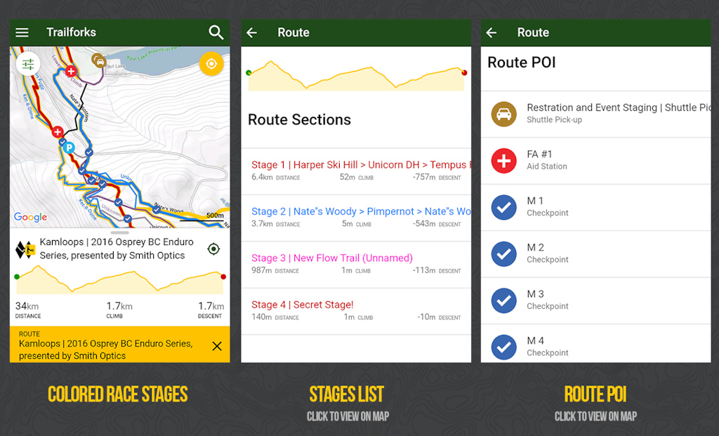
Our routes system used by race organizers has "stages" and route POI capacity on the website but this data was not shown in the app. No longer! When viewing a route in the app that has stages they will be shown on the map as the colors the creator chose. Clicking the stage name from the route detail page will zoom to that stage on the map. Route POI's like aid stations and checkpoints are now also shown on the map and the detail page. This is especially useful for race volunteers to help navigate them to marshal locations on the course.

Trailforks app update features

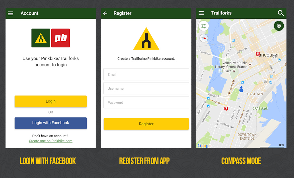
Not super exciting features, but something the app was missing. The ability to register a new account from within the app and login via Facebook connect. Which is super handy for faster login! We've also added a new feature called "Compass Mode" which is super useful to assist in navigation while out on the trail. To enable compass mode you can press and hold the yellow location button, or tap it once to center location, then the icon center turns black, pressing it again will start compass mode. While in compass mode the map will rotate based on the direction you are pointing your phone, using its internal compass. Some people have a hard time reading maps if they aren't orientated in the direction they are facing and riding, so this should assist in that. I know I've found myself rotating my phone to double check the direction of an intersection. Along with this change we've improved the compass indicator on the map when in normal north facing view. On Android, it would not show the small triangle indicator unless you were moving.

Trailforks app update features

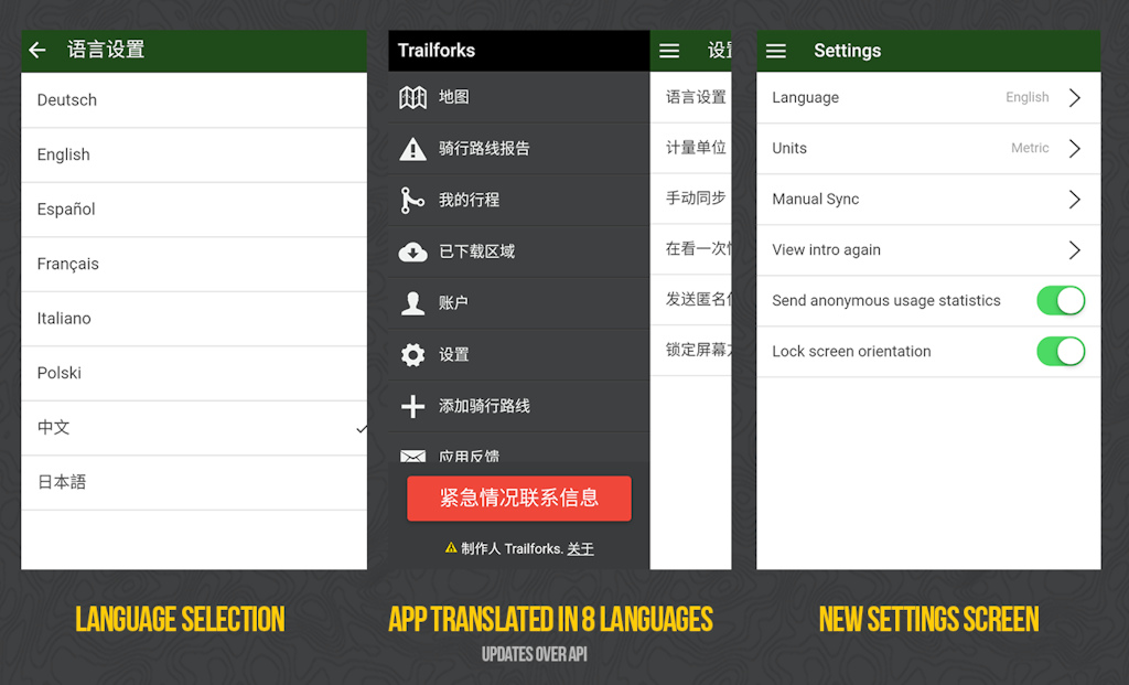
Trailforks is an international project with trails being added in over 77 countries, many places around the world are growing fast. To assist these local markets we've added translations to the app! This is only a first step, just the app UI is translated, the trail content such as names and descriptions are still in the source language.

A big thanks to the Trailforks users from around the world who helped translate the app!

- Deutsch - Alan Blank (alpinetracker.com)
- Español - Isaac
- Français - Cyril
- Polski - Przemysław
- Svenska - WAKIdesigns
- Chinese - Rice (chinabike.net)
- Hebrew - Ziv

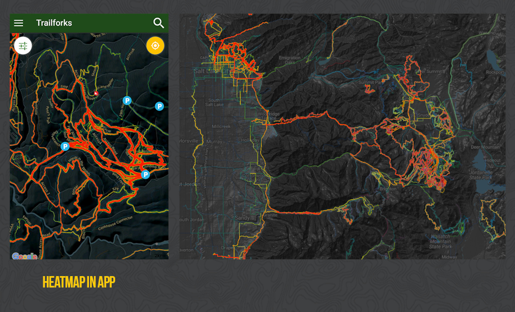
And one more key feature, you can now view the Trailforks Heatmap in the app, to assist in discovering which trails are the most popular in a riding network you visit. Along with the option to display the trails on a colored popularity scale.

heatmap view in app


control how often the GPS updates in the Trailforks app


Changes to GPS

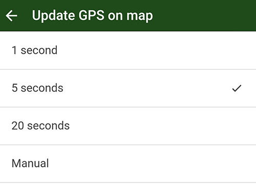
We've changed the app's backend GPS handling, which will allow us to add new functionality and give you better battery life and control.

While you have the map open, your GPS location (blue dot) will update at a default of 5 seconds. If you navigate away from the map, or to another app, this updating will stop to save battery. Also when you turn off your phone screen, this updating will stop. As soon as you turn on your screen the app will try and quickly fetch a new location then continue the interval updating. There is a new GPS settings menu where you can change the interval time for this background updating or disable it and only rely on manually pressing the yellow "locate me" button.

Additionally, if the blue dot location is old it will appear partially transparent until it updates with a current location. The compass direction will also update every 300ms.


MENTIONS: @trailforks


Author Info:
canadaka avatar

Member since Jun 8, 2010
29 articles

66 Comments
  • 84 2
 The only thing Trailforks needs now is a "suggested speed for next gap jump" feature. Then it will complete me.
  • 34 2
 With "Go full retards" as default value?
  • 8 0
 Just don't rely on it April 1st...although you'd probably get some awesome entries for fail of the month
  • 12 2
 It needs "hiking trails" where we are not supposed to ride.
And it needs Camp Site locations.
  • 5 0
 Also, a feature that lets you know if there's a mama bear with her cubs around the next corner would be nice
  • 5 1
 @Husker2112: Like Waze app, people can report fallen trees ect.
  • 3 0
 @Husker2112: I passed a Mountain Lion recently. I also had to stop using a section of trail because there seriously IS a bear with cubs around.
  • 1 0
 @WAtrailmaker: dang I thought I was kidding
  • 2 0
 @abzillah: It does have campsite locations under the POI function. Just have to be a good chap and add them! (and yes, I've added them relatively often as I like to camp as well and it adds to trip planning)
  • 3 0
 @abzillah: We have Hiking Only trails for reference. Just add them!
  • 28 2
 All I know is that there has never been a time on any trail where I haven’t been able to see my location on Trailforks, on my iPhone. This is one of the few apps that actually utilizes the phone’s GPS capabilities when the cell towers are long out of reach and for some reason Strava, Google maps, Apple maps, etc, DON’T. I don’ get it.

I have preached the virtues of Trailforks far and wide. Keep it up! It could literally save someone’s life one day. That may be dramatic but again, I’ve never lost my location no matter how far I get into the woods. Maybe one of the developers could explain this?
  • 7 0
 I suspect it's because it saves the map data to the device, instead of downloading as it goes. Although google maps now allows you to save offline maps, trailforks does it over a much larger area and by default. It's a great app, especially when riding in new places!
  • 3 1
 There are tons of map apps that work while offline by downloading and storing maps on your actual phone. If you want a map app that works without reception, you should download a map app that works without reception. Wink

I frequently drive and ride in the national radio quiet zone, a 13000 square mile area in eastern united states that prohibits most radio signals. Meaning, there is almost no mobile service at all. Offline maps work great. You just have to download one of the zillion apps that are out there.
  • 13 0
 Last week, an injured mountain biker, used Trailforks to pin point her location for search and rescue. It wasn't life and death. I bet search and rescue appreciateded it as much as the woman who was helicoptered out of the bush
  • 2 0
 same with MTB project which has been around longer, and sometimes in different areas of the country has more data on certain trail systems. You can put your phone in airplane mode and still use your phones GPS. I do this on long backcountry excursions where I need one of the apps to navigate via GPS without my cell phone battery dying.
  • 1 0
 @dfiler: trailforks works in airplane mode... as long as you have the state your visiting downloaded into the app, you can bring up the app and zoom in on the trail system your visiting for the first time and put your phone in airplane mode as your gps in your phone works and can pinpoint you at any time without a cell or data signal. Hence the reason Jason Bourne throw's out the simcard and phone to go off grid... haha
  • 2 0
 Well of course trailforks works in airplane mode. That's the whole point of an offline maps app... and also the point of my post. The difference between GPS and cellular confuses some people. GPS just needs satellite reception and it is completely unrelated to cell service. Displaying a map either requires cell service to download maps on the fly or an offline maps app that downloads and saves maps ahead of time.
  • 9 0
 I would love to see features added to support planning new trails. Something like a layer that's only viewable by admins. so you can upload your GPS after walking a proposed new trail corridor.
  • 5 0
 Already exists! Send me an email: brent@pinkbike.com
  • 2 0
 @brenthillier: Emailed as well, x2 for another Pacific NW map fanatic.
  • 7 0
 Fantastic! Congrats Trailforks and PinkBike for the app and all the work you put into it.

I'm a huge supporter and can honestly say this changed the way my spouse and I handled road trips throughout BC. No more guess work, no more getting lost, no more searching outdated websites for local trails and hot-spots. You simply roll into a community and are ready to hit the trails in no time. Wanna stretch your legs during a drive or over lunch, well just check where the nearest trail is and off you go.

Blown away by the data and inventory listed in a very short time period and it will only get better from here on. As a builder and the Chair of the Cariboo Mountain Bike Consortium, I can attest to the benefits the app brings to the table. Costly reprinting of local trail maps is history now. The ability to update on the fly is priceless. The opportunity to raise funds for local clubs is highly appreciated. Strava integration is awesome. I haven't even begun to use all the many (somewhat hidden) features.

Keep up posting tutorials and tricks on how to use.

Again, congrats and HUGE thanks to Brent and the entire Trailforks team!
  • 9 0
 The new compass mode is a great addition!!! A great tool just keeps getting better... keep being awesome!
  • 10 0
 This app is revolutionising mountain biking.
  • 4 0
 Nice work guys! Also, don't forget everyone, you can donate to the local trail advocacy group in the area you ride locally or as part of a trip if you enjoyed the trails. Since Trailforks relies on users to input the data, much of the data that has been added was added by the local trail group. One unintended consequence of the success of Trailforks is that some areas that relied on map revenue no longer have that source of income. So please donate to the trails using the Trailforks Trail Karma option to contribute to the organization maintaining the trails! This will also encourage the local groups to update the areas so that the information is as current as possible!
  • 3 0
 Amazing! Huge thanks to those that continue to work on this. It is indeed revolutionary! These things don't just pop out of thin air so thanks to those that took a chance on it, stressed about all the small features that make it amazing and worked to make the vision a reality. Awesome.
  • 2 0
 Before trailforks there was MTB project. Mtb project has some features that trailforks doesn't such as.. suggested routes and photos that pop up on the map so you can see the view and where it is on the trail. I've had many moments where I've known where I am just by doing that research on mtb project. But, I have also found the trailforks ride logs as a good feature to look at as well when planning a route. If Trailforks took just a few of those key features of mtb project it would definitely be the best trail APP out there. As I can still pinpoint gps location in mtb project so I still find myself using both for navigating unfamiliar territory. Pinkbike.. if you need someone to continuously add trails and new destinations into trailforks and give suggestions and feedback.. I will gladly take the job. Smile
  • 1 0
 Competition is good! But having to maintain trail data in two systems blows. Around here trailforks is so inaccurate or out of date that it is advisable not to use it. I'm sure the situation is reversed in other areas.
  • 6 0
 Firstly Trailforks actually started before Mtbproject but really only had data in BC. As for the features you mention Trailforks has all of that. We have routes, there might just not be any created in your area. Same with photos, you can toggle to view photos on the map, but it's off by default, clutters up the map too much. In the app we don't show the routes on the map, also clutters it up. You can use the search to show nearby routes or find them on the website and add to your wishlist.
  • 1 0
 @canadaka: Hey Canadaka, how soon can we add photos of a trail directly from the app? I know it might still need a filter for obvious reasons, but phone to web would make things waaaay easier.

Cheers!
  • 2 0
 @boxxerace: You can now do that with this update. Goto a trails photo tab and there is a + button in the top right to upload photos from your camera/phone to that trail.
  • 2 0
 @canadaka: Oh heck yeah, photo uploads here we come!

So with every trail soon to be bathed with photos, is there a way to have a rating system on the photos so the good ones show up first (unless sorted by latest photo as an secondary option)?

Cheers,
  • 1 0
 @boxxerace: Yah I should add some photo sort options in the app, the website has it.
  • 1 0
 Love Trail Forks! Actually updated my 5 year old iPhone 4S to a new model just to be able to have the app.~ Only thing is, some of our known trails aren't on the app - yet they're on Strava (not I don't mean segments, but trails.) In Cumberland, Crazy Ivan and Turkey Vulture on not on there at all... likely others as well. How do the trails get updated? Should I write UROC?
  • 1 0
 There are 4 trails like the one's you mentioned added, but they are not published. Not sure why they are not public... you can ask UROC. Maybe they want to keep them lower traffic over the winter, i dunno.
  • 2 0
 Trailforks has lots of trails listed in North America and so it works well there, but I recently moved to France and was disappointed to see that there are very few trails listed in Europe. I hope this improves soon.
  • 1 0
 Can you help add trails?
  • 2 0
 @brenthillier: Can any user add trails?
  • 1 0
 @jeppson57: Yes.That's the great thing about TF.
  • 1 0
 @kwl1: Thanks for answering that one!!!
  • 2 0
 @brenthillier: Well, I just moved here and don't now very many. :-(
  • 1 0
 Just updated...as new new user I was pumped to quickly find and ride some of the great trails in the Whistler valley last week. Loving it......loving not having that lost feeling anymore. Ps us Cunucks are rocking this form with lotsa possi feedback!
  • 1 0
 Incredible app! Always use it, only thing I would like to see in the near future would be the ability to add trails from your phone, I struggled to do this and do not have a computer to do it.
  • 2 0
 Let's name some of the zones you've been able to ride with the help of this app. For me the main ones to come to mind are Leavenworth and Pemberton.
  • 1 0
 Squamish!
  • 1 0
 Revelstoke
  • 1 0
 Pemberton, Whistler, Chilcotins (!), Winthrop
  • 2 0
 Great stuff guys, love the app and use it all the time! I'd still love to see elevation labels on the contour lines, maybe in the future?
  • 1 0
 This is actually very very easy, if we could all just agree on using metric. It gets more difficult to paint the background tiles differently based upon the users units preference.
  • 1 0
 That map image depicts a 10,000' view of the Salt Lake/Park City area. Something is wrong with it though. There's no trails here and there's too much water in the beer.
  • 1 0
 Having a hard time clearing the route highlight feature when reviewing ridelogs and the closest route feature. Submitted via email
  • 1 0
 Thank you trail forks. You make exploring new areas so much easier. Have been ticking off some awesome Valley trails in whistler thanks to you Smile keep up the good work!
  • 1 0
 I have a Windows Phone. There are literally dozens of us. Wish this was available for it.
  • 1 0
 Awesome!

Does the heat map only work on trails in the app, or the whole ride?
  • 1 0
 Whole ride, trail doesn't need to be added to TF. But we do filter the heatmap to remove data around sensitive trails and areas.
  • 1 0
 I like the heat map feature. Dumb question how is the data captured to determine heat signatures for the trails?
  • 1 0
 From users submitting ridelogs, mostly by connecting their Strava accounts.
  • 1 0
 How are trails added? Not much in the app here in the CT / RI area...
  • 1 0
 Add them at trailforks.com from a laptop, you'll need to plot the trail and save it! Then once the admins approve they appear in your area- helping other riders and tracking numbers for land managers. Check the videos for 'hot to's'
  • 4 0
 I'm in Western MA and have been trying to add trails whenever I get the time. The easiest method I've found is to import Strava ridelogs and crop my rides into the individual segments within the Trailforks web interface. It's a bit tedious at times but it only needs to be once.
  • 1 0
 Awesome app! Helped me navigate Sedona last week. Thanks guys!
  • 1 1
 trailforks rocks ass. brilliant work. that is all.
Below threshold threads are hidden


Copyright © 2000 - 2024. Pinkbike.com. All rights reserved.
dv65 0.050658
Mobile Version of Website