Spruce Lake (South Chilcotin) Trails Update - June 2013
Trail information courtesy of BikeCo (thanks Pete and Johnny), Tyax Adventures and Craig/Ina Hunt.
Thanks to Tyax Adventures (shout out to their new funky website and blog, Tyax/Gun Lake locals, Braelorne locals and Craig/Ina Hunt, Dale Nagata and Chris Barker for the trail work and cutting out blowdown
General
• Lake ice melt and snow melt is a good 2 to 3 weeks ahead of last year's epic alpine snowpack. While there's generally still a lot of snow in the alpine, south faces are melting out nicely. North faces will be a trudge still of course
• River level wasn't bad, but it does get higher in the afternoon after the melt off during the day.
• Drive over the Hurley is in rough shape but two graders work working on it on the weekend of June 15th - 16th should improve road conditions
![photo]()
![photo]()
Spruce, Warner, Gun Lakes areas
• Lower and Upper North Cinnabar trail are in the process of being cleared
• Gun Creek trail to Spruce Lake is clear
• Taylor Basin and High Trail still has lingering snow patches so expect wet feet till that melts out; perhaps by early July
• Warner, Trigger, Hummingbird Lakes trails now clear.
• Climbing road up from the Tyaughton trail head to the higher trail so you can ride up vs. hike a bike up the horse trail is clear to the first little creek crossing.
![photo]()
![photo]()
Braelorne
• All the stuff around Braelorne is open.
• Sunshine is going to be logged in the near future so that will be closed for a while.
• The trail up Mt. Fergusson is buried by avalanche debris so no Bendor Ranging till that melts out.
![photo]()
Miscellanous
• Area W of Lone Creek to Dash Hill is getting logged and has cutblock markers. If you explore in that area trying to get around Dash Hill on its N side expect beautiful terrain with some sporty alder bashes. Budget about 12 hours to get around Dash to get to Graveyard Cabin
• 9 Mile Ridge up the Yalakom is rideable to the alpine as of 2 weeks ago. It may be clear by now.
![photo]()
Maps!
Finally, last but not least the Province of BC courtesy of a hard-working GIS team lead by Jamie Duncan have provided, for free, GeoBC a mapping database containing maps of all the Province of BC in 1:20,000 TRIM data format with placenames and useful GIS layers downloadable in PDF format perfect for printing. The maps correspond to the official Canada 1:50,000s but have way more detail. Such a huge timesink for map geeks, but such an incredible resource.
Enjoy the maps. Enjoy the trails
Thanks to Tyax Adventures (shout out to their new funky website and blog, Tyax/Gun Lake locals, Braelorne locals and Craig/Ina Hunt, Dale Nagata and Chris Barker for the trail work and cutting out blowdown
General
• Lake ice melt and snow melt is a good 2 to 3 weeks ahead of last year's epic alpine snowpack. While there's generally still a lot of snow in the alpine, south faces are melting out nicely. North faces will be a trudge still of course
• River level wasn't bad, but it does get higher in the afternoon after the melt off during the day.
• Drive over the Hurley is in rough shape but two graders work working on it on the weekend of June 15th - 16th should improve road conditions
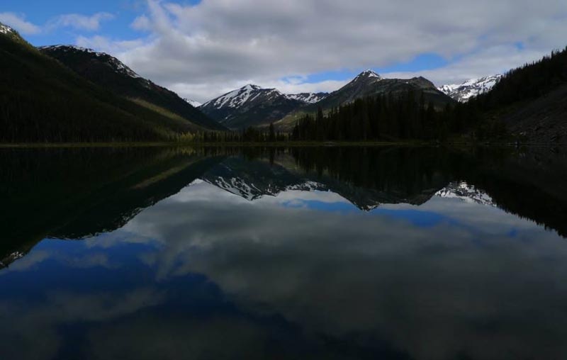
Trigger Lake - picture by Adrian Bostock

Gun Creek chainsaw ride - picture by Adrian Bostock
Spruce, Warner, Gun Lakes areas
• Lower and Upper North Cinnabar trail are in the process of being cleared
• Gun Creek trail to Spruce Lake is clear
• Taylor Basin and High Trail still has lingering snow patches so expect wet feet till that melts out; perhaps by early July
• Warner, Trigger, Hummingbird Lakes trails now clear.
• Climbing road up from the Tyaughton trail head to the higher trail so you can ride up vs. hike a bike up the horse trail is clear to the first little creek crossing.

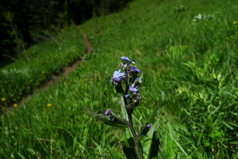
Balsam root in full flower on Gun Creek - picture courtesy Tyax Adventures
Generic beautiful BC alpine meadows - picture by Adrian Bostock
Braelorne
• All the stuff around Braelorne is open.
• Sunshine is going to be logged in the near future so that will be closed for a while.
• The trail up Mt. Fergusson is buried by avalanche debris so no Bendor Ranging till that melts out.

Mr Grizz is awake - picture courtesy Craig and Ina Hunt
Miscellanous
• Area W of Lone Creek to Dash Hill is getting logged and has cutblock markers. If you explore in that area trying to get around Dash Hill on its N side expect beautiful terrain with some sporty alder bashes. Budget about 12 hours to get around Dash to get to Graveyard Cabin
• 9 Mile Ridge up the Yalakom is rideable to the alpine as of 2 weeks ago. It may be clear by now.

Geoff of Tyax Adventures hard at work with the saw - picture courtesy Geoff Playfair
Maps!
Finally, last but not least the Province of BC courtesy of a hard-working GIS team lead by Jamie Duncan have provided, for free, GeoBC a mapping database containing maps of all the Province of BC in 1:20,000 TRIM data format with placenames and useful GIS layers downloadable in PDF format perfect for printing. The maps correspond to the official Canada 1:50,000s but have way more detail. Such a huge timesink for map geeks, but such an incredible resource.
Enjoy the maps. Enjoy the trails
Author Info:

Must Read This Week
Sign Up for the Pinkbike Newsletter - All the Biggest, Most Interesting Stories in your Inbox
PB Newsletter Signup
We currently have 2 trail crews out working on the trails in the area. One crew is based out at Lorna Lake working on upgrading the trail out Big Creek. The second crew is a horseback crew and will be working on clearing out the WD, Tyaughton Creek, Little Paradise and perhaps more should they have time.
Our crew also cleared both sides of the Deer Pass trail last week.
Tyax Adventures wants to give a big shout out to everyone who've helped with the trail work this year and over the years! This beautiful remote area has hundreds of kms of trail and limited users so every little bit of help counts. Much thx.