Review: Lezyne Super Pro GPS Computer
Lezyne are well-known for their tools and lights, but they also offer a lineup of bike computers. We’ve had their Super Pro GPS unit in our hands over the last few months to see how it stacks up.
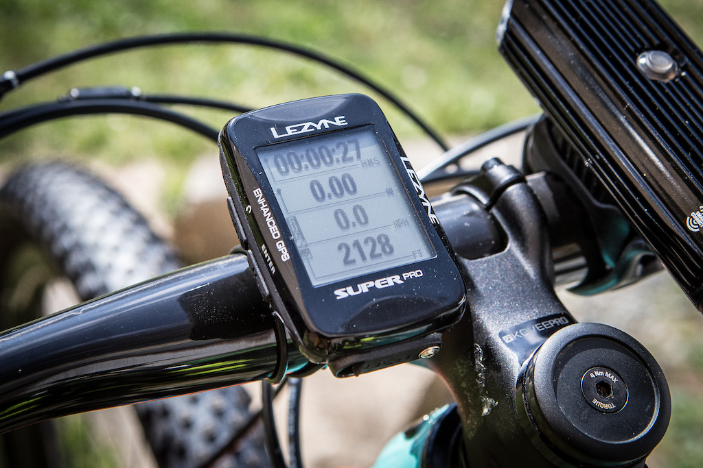
The Super Pro GPS is Lezyne’s $149.99 USD computer that sits in the middle of the range, and it features a black and white screen and four buttons to navigate the fields of data. It syncs to a smartphone to allow more user control and the added integration of training apps, and can also be mounted either vertically or horizontally to your handlebar.
The Super Pro GPS is Lezyne’s $149.99 USD computer that sits in the middle of the range, and it features a black and white screen and four buttons to navigate the fields of data. It syncs to a smartphone to allow more user control and the added integration of training apps, and can also be mounted either vertically or horizontally to your handlebar.
Lezyne Super GPS Details
• GPS and GLONASS, Bluetooth Smart, ANT+
• Vertical and horizontal mounting
• "Smart Connect" also controls lights
• Small size, lightweight
• Smartphone connectivity, turn-by-turn capable
• MSRP: $149.99 USD
• www.lezyne.com
• GPS and GLONASS, Bluetooth Smart, ANT+
• Vertical and horizontal mounting
• "Smart Connect" also controls lights
• Small size, lightweight
• Smartphone connectivity, turn-by-turn capable
• MSRP: $149.99 USD
• www.lezyne.com
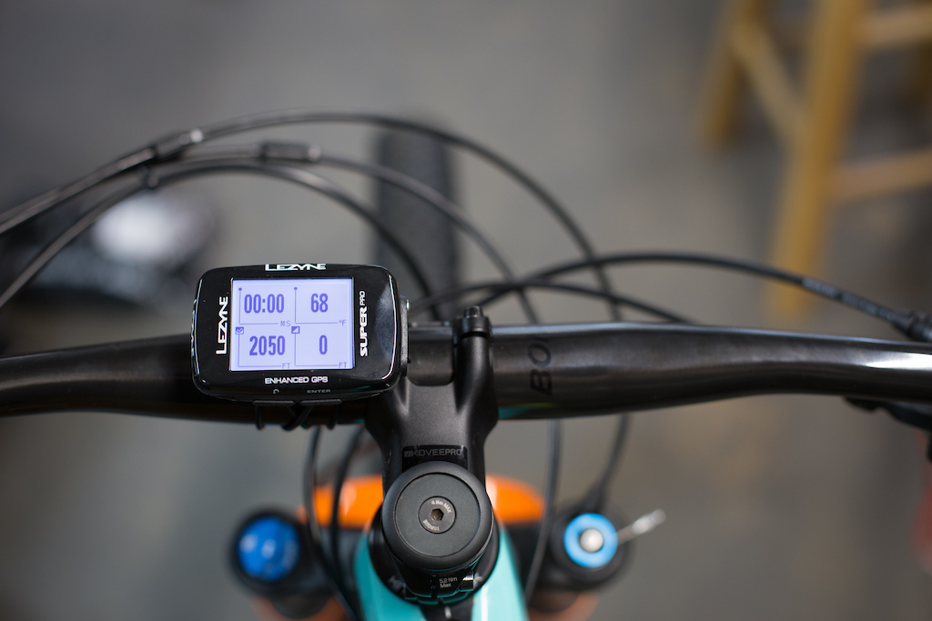
Super GPS Functions
The computer has the standard current, average, and max speed functions, as well as elevation, heart rate, power, cadence, and all the other usuals. It also has the ability to relay calls, texts, and email notifications on the screen if you’re in cell phone range, a common feature for many GPS units. There’s live tracking, too, that can be set up from the phone to allow contacts you select to get an email with a link to track you during your ride in real-time. They can view all of the ride data that you want to share with them, a function that could be attractive for 24-hour team racing or other adventures where that's relevant.
The Super Pro GPS works with Strava Live and can sync those segments up through the Ally V2 app on a smartphone. It also pairs with Lezyne's lights through their “Smart Connect” LED system. Pairing the GPS with a phone, power meter, or heart rate strap is a simple process and once paired, I experienced no issues with the GPS; the sensors connected as soon as I turned it on.
A separate app is needed to sync the lights.

Once loaded, users have multiple options for lighting that aren't available by the push of a button on the light itself.
In order to pair the lights, you first have to pair them to your phone and then it can talk to the computer. Mountain bikers can control the tail light via the front light, so riding to and from the trails in early morning hours takes a couple less clicks. The tail light can be programmed via the app to have an “off” mode, so that it’s a quick and efficient means of not blinding fellow riders. Users can program up to four modes with the app, choosing from a wide range of light outputs.
The computer also now sync's with the Komoot and Relive apps for users interested in the features those provide. The Komoot app can aid in route planning for touring and road riding.
Performance
Out of the box, the Super Pro GPS is easy to mount and sync to heart rate and power sensors, as well as a smartphone. Setting up different data fields via the phone is painless, and tying in all of the apps that tell your friends how much you rode is easy as well. Syncing the computer up to the lights proved to be more challenging at first, but a quick firmware update made everything connect nicely.
In its most simple form, the computer is fairly easy to use while on a ride and I experienced no issues of losing GPS signal. It relays messages as advertised and keeps the data you choose nicely organized on the screen. The mount for the computer isn't compatible with anything other than Lezyne's mounts, but it is more secure than a Garmin or Wahoo unit.
Connectivity to power and heart rate data is flawless, and the metrics are easy to read on-screen. Battery life is superb as well, lasting longer than any Garmin or Wahoo computers I have used and going a number of rides more between charges. Sending post-ride data to training apps works as advertised, too.

Setting training zones in the Ally V2 smartphone app is straight forward and everything quickly syncs to the computer.
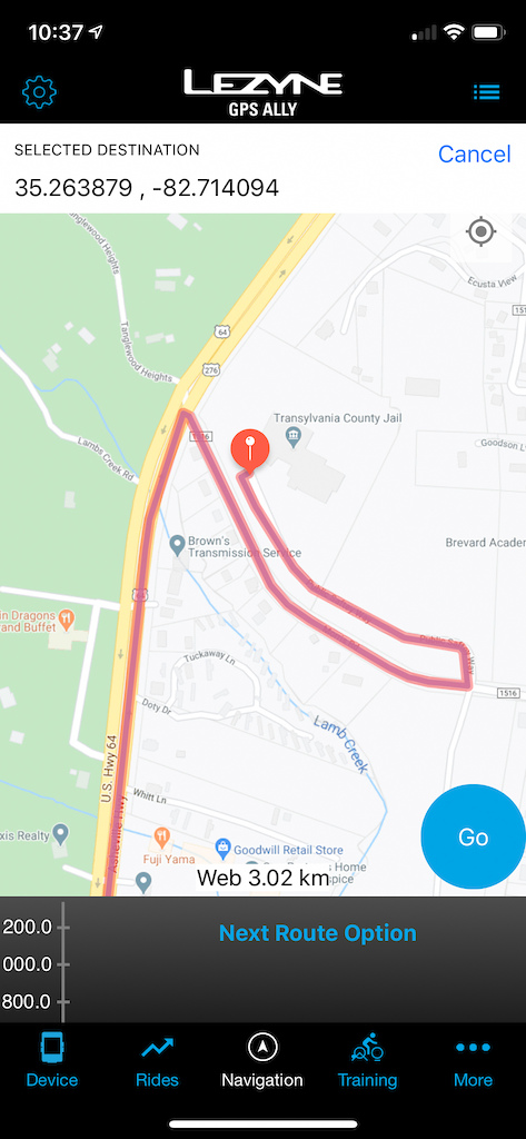
Navigation requires loading a route from your phone to the computer. There's no pre-loaded base map, but there are turn-by-turn directions. Routing doesn't always seem to follow the least traveled roads or greenways, in my experience although you are able to select your preferences in the app, according to Lezyne. The ability to do this is a little hidden right now, but they claim to be adding a pop-up feature that will make it much more clear.
Some of the other features are clearly aimed at our road-going cousins. The on-the-fly GPS navigation is a cool feature, but it doesn’t work intuitively with trails and, in my experience, it doesn’t pick up greenways or better paths for bikes than the main road and shortest distance from A-Z (I mentioned this to the team at Lezyne and they told me there's a way to select this but, even knowing this, it proved to be a more confusing process than it should be.)
There's also no base map loaded as there is on a Garmin, and loading any routing requires using a smartphone. While in the “Offline Maps” window, maps can be downloaded before riding and sent to the GPS. If “Offline Routing Preferred” is selected, your phone can still provide navigation features without phone service if the data is saved on the phone of the area downloaded. This is something you'll want to do if you might be out of cell service. The map and routing functions will be more useful "out of the box" for someone commuting or road riding than mountain biking as it can provide turn-by-turn directions without having to preload GPX/TCX files made in a mapping app (RideWithGPS, Strava, Trailforks), programmed into your Lezyne account, and finally uploaded onto the device.
The "Smart Connect" function of pairing lights and being able to control them from the head unit works, but it's difficult to navigate. It's a feature that's more designed for commuters, but it's there if you need it. Overall, while the computer's basic functions were all easy to use and navigate, it falls short when it comes to off-road navigation and the interfaces were more confusing than other computers I've used.

Lezyne's mount interface is more secure than most others as you have to press the computer down and rotate it.
Pros
+ Excellent battery life
+ Easy to mount securely
+ Easy to sync to heart rate and power sensors, and smartphones
Cons
- Not very intuitive to use - there always seemed to be one more step than there should be to accomplish what was needed, especially in navigation, which proved frustrating
- The mapping functions better suit road riding than mountain biking
Pinkbike's Take
 | At $149.99 USD, the Super Pro GPS is one of the more affordable full-function GPS computers available but, I didn't really get along with it. It's clear that some of its functions are far more useful when on the pavement than the dirt. Commuters and roadies will find the computer useful but, when it comes to mountain biking, it's a hard sell unless you're purely focused on your speed, cadence, heart rate, and power output. |
Author Info:

Must Read This Week
How to Watch the 2024 Mountain Bike World Cup [Update: Staylive Offering Access in New Zealand, South Africa & More]
60388 views
60388 views
[UPDATED] Final Elite XC Results & Overall Standings from the Mairiporã XC World Cup 2024
41287 views
41287 views
Sign Up for the Pinkbike Newsletter - All the Biggest, Most Interesting Stories in your Inbox
PB Newsletter Signup
oh no wait a second this isn’t road riding and none of us have actual real jobs
On a serious note, emails and other notifications can be selectively or completely turned off. If you're into tracking your rides but don't want to have a GPS on your bars, you can even put it in a pocket and just record it that way.
I'm sure most people do turn the email function off, but for those that don't we'd collectively like to have a word with you. People need to unplug now more than ever.
1. Does the device have maps and a map page? YES - Our devices don’t come preloaded with a base map BUT you can download different base maps anywhere in the world for free depending on where you’ll be riding. Multiple different base maps can be downloaded and sent to the GPS, and the device will automatically use the correct one.
2. Does the device show trails? YES – Our base maps are mostly derivative of the Open Street Map. If your local trails are on there, they will be on the GPS when you download a base map.
3. Does the device navigate using trails? YES – There are a few different ways to use navigation on the devices. “A to B” as we call it, was mentioned in the review: In the app, click on your destination or type in an address, and our navigation engine will provide you with multiple route options with different profiles you can select (Mountain Bike, commuter, road bike, easy ride, shortest, and hiking). Another way to navigate is to create a custom route in the app. With this, you can choose exactly where you’d like to ride and the GPS will take you there. Again, if the trails you want to ride are on Open Street Map, you can navigate with them. The third way to navigate is to use our route builder on GPS Root or another service such as Komoot. Create exactly the route you’d like in either, and the GPS can follow that. The device can always follow .TCX or .GPX files.
4. Does the device have to show me emails and other notifications? NO – those can be selectively or completely turned off in the app. If you want to ignore all of your work emails but still get notified when someone comments on your sick Instagram edit, you can do that (#influencers)
Hopefully this clears some things up. We’d be happy to continue answering questions here for a bit if there are any more.
Cheers,
The Lezyne Team
RE: Trailforks - You can already export a .GPX file and use it to navigate with our system! Here's an article which describes how to do so at the bottom: support.lezyne.com/hc/en-us/articles/115004258573-Navigation-Loading-Navigation-Routes-and-GPX-files-versus-TCX-files
Cheers!
Side note while your responding to customers (which is amazing by the way) come up with an in-house mount for the top cap. K-edge has their “Gravity” one but it adapts from the Garmin mount and is clunky and ugly.
Thanks and keep up the good work.
Here's a screenshot of our app using the offline maps. It shows the trails at UC Santa Cruz (trail detail changes with zooming). Everything you see on the offline map can be used to create a route and navigate: www.pinkbike.com/photo/18657109
Also, we will definitely forward your idea for the top cap mount on to our development team. : )
Hopefully this clears things up a little! If not, always feel free to reach out to our team with any questions via the support site.
Garmin has made amazing strides in GPS and continues to be at the front of the industry. Check out their newer watches, even the entry level multisport platforms offer full range of sport activities with 8-24 hours of full feature GPS recording.
Cheers!
Bottom line, it's been an accurate GPS that pairs with with phones and devices easily and does exactly what I need it to do.
I have gone through two sensors and now on to my third. They seem to have a common issue of condensation leaking into the battery compartment and frying the battery. Lezyne have been helpful in warrantying these but something worth noting!
Also if you intend to sync these up with Strava Live Segments - these will only work with climbing segments since Strava has removed live segments for anything downhill (ie. less than 0.25% gradient). I only learned this after signing up for Strava premium for another year..
Lezyne's customer service and IT teams are super helpful though, can't fault them there!
I just want an honest true gps device that gives me a map and a track.
www.pinkbike.com/photo/18654843
www.pinkbike.com/photo/18654842
www.pinkbike.com/photo/18654844
Cheers!
What about it compared to a Bryton 420E?
I see the lezyne track / live track to be a great option but can it be shared with any number of people (e.g putting the link to my facebook feed)?
Does it have a smart lap function, like setting a gps point as the round start / finish?
I have a Wahoo Tickr 2 chest strap that I really like. Is it compatible with?
The interface is so bad a pager from the 80's is more user friendly.
After using this piece of cr*p I finally understood how my grandfather felt trying to use Facebook.
The android app is utter garbage as well.
I really cannot stress enough how bad the product is.
Won't track my rides, nor am I thinking about mileage, speed or anything... just climb, descent, have fun and zone out of everything else.
I have the Micro C watch and now the
app and user interface is much better than before.
It's been 6 months since I bought it, and four since I gave up using it at all.
Cheers!
www.strava.com/athletes/5000861
I've been using a Garmin device, which proved to be much more user friendly and overall easier to use. It even updates automatically, I don't have to connect it to a computer...
And I did contact Lezyne customer support, which told me to update the firmware solving the freezing issue, but not the outdated and barely usable Android app, nor the terrible GPS user interface. Even the Windows update system feels like it's from the 90's!
So before calling people out on pinkbike, sort you products so they don't feel like a trip to 1995.
Sincerely a very disappointed customer.
My main scope was to map and follow tracks.
To upload and create maps was a pain (maybe it is better now – i doubt it).
I used it two times.
On a 140 miles ride in and the GPS lost connection half way through.
On a 8 hours ride in the Alps – in the middle of nowhere – the battery was drained within 5 hours (they advertise 15, I figured it should last eight). It was getting dark and I don't even know how I found my way back.
I returned to REI and got a eTrex20.
This is more primitive, but very reliable. AA batteries last 20 hours. Creating and uploading the maps is a pain.
It does not have cycling specific features. The screen is very small. No touchscreen (which is good).
Interface etc. it is bad and not intuitive on both.