Trailforks Aids in Another Rescue of Injured Mountain Biker in Penticton, BC
Trailforks working with Park City Fire Department to discuss search and rescue.
Just a little over a month after we reported on the Trailforks app being used to help locate an injured mountain biker in Penticton, BC, and now search and rescue crews in the same area have utilized the app once again.
According to a press release, the 25-year-old mountain biker was on the Three Blind Mice trail network and received a severe injury to their leg on July 6th. An off-duty firefighter at the scene assessed the situation and provided location information using the Trailforks app to search and rescue. Along with BC Ambulance, the PENSAR helicopter team was called in to transport the rider off the trail.
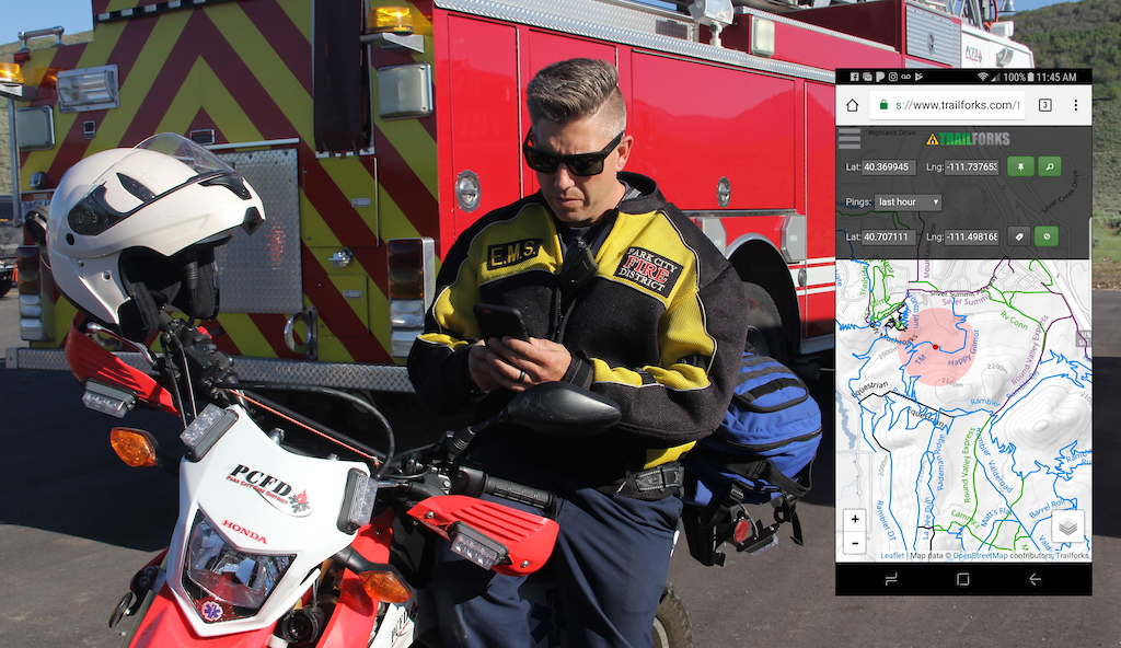
Trailforks SAR Interface
The Trailforks SAR interface shows your position with included accuracy bubble and the coordinates of the injured rider. As you travel towards the victim, the map auto-zooms in to always show where you are in relation to the target. You can reset the target if information changes and the interface will auto-reset zoom and location to include your location and target.
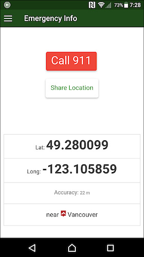
The Trailforks user side emergency interface.
The real power of the module comes in the accuracy of the Trailforks data and the outdoor usability of the map interface. When you have to glance down at the map in full sunlight, having accurate trails overlayed on our high contrast custom basemap makes location acquisition quick.
On the Trailforks application user side, there is an option to use the emergency button which will both dial out to emergency services and provide their location in large latitude/longitude numbers. On some phones, when tracking is not being used within the app, the location that the phone reports can sometimes be way off. Some phones will try to use Wifi triangulation or other means to estimate location. Using the handy emergency feature in the app will force the phone to try to get a good GPS fix and report your location in big and easy to read numbers.
Usage of the 911 dial-out feature in the Trailforks app is not required for the SAR module to work, as they run independently. Often the PCFD relies on the 911 dispatch to provide the GPS coordinates as reported by the phone.
From the emergency page, you can also "Share" your location which will generate a link. When sent and opened by another user a pin of your location will open on their app or website.
For more information on how your SAR Group or Rescue outfit can get better connected, send an email to: support@trailforks.com
Author Info:

Must Read This Week
Sign Up for the Pinkbike Newsletter - All the Biggest, Most Interesting Stories in your Inbox
PB Newsletter Signup
It was on bronco which is in the mice. Maybe you should learn the area better?
There also was a campbell mountain rescue this week as well.