Stories posted under Pinkbike Community blogs are not edited, vetted, or approved by the Pinkbike editorial team. These are stories from Pinkbike users.
If a blog post is offensive or violates the Terms of Services, please report the blog to Community moderators.
Response to Criticism That Trailforks Is Now Charging for Access
The public announcement article explained many of the reasons and common questions regarding the Trailforks Pro subscription model. The Pro FAQ page also answers common questions.
The amount of questions, concerns and comments right now is just plain massive. Before we introduced Pro, it took a full-time staff member just to respond to Emails. As it turns out, the world is a very big place, and there are a lot of trails, trail associations, trail builders, land owners, event organizers and municipal planners. Imagine thousands of these entities, not all, but many, reaching out to Trailforks every time there is something new on the map that they want...different. So we want to address these major concerns in one article right here.
Trailforks is not selling access to the user contributed data with Pro subscriptions. The data such as reports, photos, videos, routes, ridelogs, trail descriptions, events and badges are unchanged in the app & website. Access to this data is still freely available.
What has changed is how some of the trail GPS data is viewable to non-pro users in the mobile app. The trail GPS data is still freely available on the Trailforks website, the mobile site, Garmin integrations and in a grayscale form in the app outside your free area. Users get a fully unlocked map around a free area of their choosing, trails outside this area on the map are still visible for basic navigation, they are greyed out removing some detail unless you subscribe to Pro. But access is not removed and one can choose to use the website. Additionally routes viewed from the search, wishlist, ridelogs, or discover page are still visible on the map even in a greyed out area.
Trailforks is not charging to access the trail data, just to get the best viewing experience on the app. With more new Pro only features coming in the future as we gain more funding resources. We have a long list of exciting new features and improvements to come! Spring 2021 we started adding many new data layers to the app, these new layers are available to all users in their free trial or in their free region to try out. Then when they upgrade to Pro, they can use anywhere in the world.
Every time the app, website or widgets are used, external services (map tiles, Google maps, satellite imagery, elevation data, weather data, and more) have a cost associated with it. We have been able to absorb the cost until now, but as more and more users use the app we just can't absorb this indefinitely. When you scale to the world and millions of users, things get expensive.
This is probably the most important concern to answer, but to answer it first requires some understanding of the trail data life cycle. First, you can’t just start a trail website and ask people to contribute trail data to an empty website, it just doesn’t work that way. You can try to populate your trail database from data in the public domain, but that data is generally of poor quality, with old and out dated information. Especially when we are talking 6-7 years ago. Trailforks has always strived to have the most accurate and up-to-date trail information, and to do that from scratch you have only one ethical choice...and that is to front the cash. In addition to paying staff to procure data, we had to purchase quality data as well. Then build complex systems to manage, curate and moderate the data. At the same time spending money over many years marketing the product for growth and adoption.
Of course, we have thousands of contributors, and they are awesome. Most freely give of their time, and have helped make Trailforks what it is today. Many have backgrounds in GIS, while others have natural talent and desire. The reasons for their passion is wide and varied. Some do it simply to provide their community with trail knowledge, while others contribute to help get money to associations through Trail Karma, and some just enjoy making maps. Many groups use the Trailforks Trail Management system to embed maps on their website or use the Printable Map interface to create Kiosks. But the majority of the trail data in Trailforks was contributed by paid staff and provided by “Power Users”. For those users, Trailforks Pro is free. Trail associations that provided their data and help to moderate their local trail information get Trailforks Pro for free as well.
And as great as our contributors are, unfortunately many do not have a background in geographic information systems. Many often don’t know the local rules or how to use our background rideline layer to trace an accurate and connected map. For much of the data that gets contributed, a cleanup process is required. Depending on the data the vetting, re-alignment, connecting, regional organization, re-classification, process can be extensive. This process often includes communications with both the contributor and local land owners. A lot of the work that the staff do is also “unseen”. There is a full backend system to document illegal trails, so that users can’t re-add them back to the map after they are removed. Most users don’t know this, because they never see the illegal trails on the map.
A query of the database shows of the current 304,781 trails added, 240,144 were added by users who are already eligible for FREE Pro subscriptions. So we are not forcing the users who helped create the map to pay, we appreciate their continued contributions and reward it. We will look at further incentives in the future to capture more of those missing users who helped contribute less data or in different ways.
Currently there are 2,712 users who contributed the bulk of the trail data eligible for free subscriptions.
Additionally there are 1,605 more users from trail associations that are eligible for free subscriptions.
We have covered the majority of users who "helped create" and manage the Trailforks platform.
Number of Trails Added By Users
![photo]()
40,121 of the trails in the green pie area were directly added by Trailforks staff. And Trailforks staff are often involved with cleanup or moderation of many of the other trails.
Many apps in the trail or mapping space have a paid subscription models with lots of user contributed data, this is not out of the norm. AllTrails, Strava, Gia, ViewRanger, OnX are a few examples.
Access to other content that takes less effort than mapping trails like adding photos, reports, videos, comments and ridelogs are still freely available on the website and the app, free or pro.
"If You're Not Paying for It, You're the Product"
I'm fairly certain we would have equal or more complaints if we added advertising to the app rather than a paid subscription. As outlined here, we had to monetize Trailforks to make it self-sustainable. Plastering the app and website with advertisements would severely diminish the user experience. Trailforks customer becomes the advertisers rather than you the rider. To maximize our revenue so we can pay our costs and build all the rad future things we have planned, we would have to optimize for advertising and the requests of advertisers. Joining the game of the "attention economy" with all the sneaky tricks the social media companies deploy to try and increase your usage time in their apps to get the most amount of ad views. We also don't want to collect and sell user data with advertisers. This is not a game we want to play, nor do we think most users want!
The Trailforks website and mobile site are still free and accessible via a phone.
"Useless" is very much an exaggeration! As stated before, the map is greyed out beyond your free area, but trail lines are still visible for basic navigation. Your location it still shown on the map, you can still click a trail to view some basic stats and it's status on the map. But the vast majority of functionality that makes the Trailforks app a powerful tool and USEFUL is still available for free.
You can still...
- View and post trail reports including conditions
- View routes & user rides that include a selected trail
- View routes from search, wishlist, discover
- View top trails, routes, photos and personalized recommended routes for a region on the discover page
- Search for trails
- Record your ride
- View your own ridelogs and feed of friends rides
- View trail details like description, photos, videos, reports
- More trail detail page info like average time to ride trail, relative local popularity of trail, direction of trail, usage of trail
- View race routes
- Post photos for trails
- Log trail work.
- View all info on a region detail page (description, trails, routes, reports, photos, videos, events, rides)
- View events, contests, badges
- View regions trail status board
- View your location on the map
- Access the emergency page, and unlock the map in case of emergency 3 times
- View land owner overlay (find free BLM camping)
- View Strava segments on the map
- Save trails or routes to wishlist, rate trails, comment on trails
- Donate trail karma to trail associations
- Access winter map unrestricted
- Free use of the Trailforks website and mobile site
- Subscribe to Pro to get the full app map unlocked, pro only features and support continued development of Trailforks
![photo]()
In the 6 months since Pro was launched, every month has been record setting for the amount of new trails mapped to Trailforks. So rather than diminishing contributions, it has actually increased.
![trails added per month]()
The amount of trails and other content being added has been increasing every year with a spike through 2020, so much so it's too much to manage for our small team. We require more staff to assist in moderating & contributing in-house content. We are confident the amount of contributions will continue to rise in the long term, as the growth of new users and app installs each day continues to grow. We are thinking about our next million downloads & users and how best to serve them with a better product and support through more resources funded by Pro revenue.
For contributed content like trail reports and conditions, most of the time reports are added by locals for their local trails. You can always view and submit reports on the app, free or Pro. Even with the free version of the app you can see the map fully inside your free home area, to submit reports. Additionally more reports are added via the Trailforks website than via the app, the website is unchanged and free access.
No other platform comes close to the robust features around trail reporting that Trailforks offers, this is still all free.
We believe we do more than our fair share to give back to the trail community. We create and promote features like Trail Karma, focus development time creating free tools, data & statistics for trail associations. We provide them with a free map, print maps, management platform, widgets, free pro subscriptions, support and recognition.
Learn more about the benefits of Trailforks for trail associations.
![photo]()
Trailforks & Pinkbike also directly donates to our local trail orgs and helps with fundraising events and initiatives.
But we are going to do more!
We also have multiple ideas on how we can share some revenue, or give back directly to trail associations. There are a bunch of options and we are consulting some trail orgs. No timeline on the rollout of this, but we are working on it!
With more resources in the future from Pro revenue, we can make more tools targeting trail association and builder needs. With limited development staff, it's been hard to prioritize new tools and features that would benefit trail associations that are used by a small amount of users. Compared to working on a new feature or improving an existing general feature that targets the average rider.
Increasing Amount of In-House Content
Since introducing Trailforks Pro we have added a large amount of non user-generated content or in-house content. Along with Trailforks staff adding trail content ourselves we've added a range of new map layers created by Trailforks.
New layers include Jumps Heatmap, Activity Recordings, Elevation, Avalanche Risk, Avalanche Forecast, Air Quality, Percip Forecast, Snow Forecast, Current Fires, Smoke, USFS & MVUM trails
We will be investing in creating more data layers and in-house content increasing the value and utility of Trailforks. Additionally in the future we will integrate more content from other Outside brands.
Why We Created Trailforks Pro
We truly appreciate all the support of our users over the last five years that Trailforks has been free but in order to continue to be great, we have to start charging.
Every premium service has to find a way to pay the bills eventually, we had 3 options, plaster the website & app with advertising, charge trail associations, or charge users. We dislike ads and the tracking of users across the web it involves. We have never and don't want to sell user data, or even force users to have an account to use the app & website, thus tracking them even more. And one of the core missions of Trailforks is to provide tools and data for non-profit trail associations, so charging them doesn't align with that. So we decided on a reasonable yearly subscription for users, which can be purchased even without an account.
Every time the app is used, external services ( map tiles, Google maps, satellite imagery, elevation data, weather data, and more ) have a cost associated with it. We have been able to absorb the cost until now, but as more and more users use the app we just can't absorb this indefinitely. Then there are the costs of server hardware, bandwidth costs, staff salaries, events and so on.
We have tried to strike a balance between free access and a sustainable payment model. Our view is that users actively participate and contribute to Trailforks in their local areas, so that should be free. For users wanting access to Trailforks Pro worldwide, we hope they see enough value to spend the equivalent of a couple of post-ride beers at the pub.
The revenue from Trailforks Pro will enable us to hire more staff, develop additional features, provide better support, and improve our infrastructure. Subscribing to Trailforks Pro is your way of supporting Trailforks and it's continued improvement and operations. With your support, we’re excited to make Trailforks even better!
![Trailforks Servers]()
Lear more about how you can still use Trailforks for free.
The amount of questions, concerns and comments right now is just plain massive. Before we introduced Pro, it took a full-time staff member just to respond to Emails. As it turns out, the world is a very big place, and there are a lot of trails, trail associations, trail builders, land owners, event organizers and municipal planners. Imagine thousands of these entities, not all, but many, reaching out to Trailforks every time there is something new on the map that they want...different. So we want to address these major concerns in one article right here.
 | No longer an open community. Now selling the community provided data back to the community instead. |
Trailforks is not selling access to the user contributed data with Pro subscriptions. The data such as reports, photos, videos, routes, ridelogs, trail descriptions, events and badges are unchanged in the app & website. Access to this data is still freely available.
What has changed is how some of the trail GPS data is viewable to non-pro users in the mobile app. The trail GPS data is still freely available on the Trailforks website, the mobile site, Garmin integrations and in a grayscale form in the app outside your free area. Users get a fully unlocked map around a free area of their choosing, trails outside this area on the map are still visible for basic navigation, they are greyed out removing some detail unless you subscribe to Pro. But access is not removed and one can choose to use the website. Additionally routes viewed from the search, wishlist, ridelogs, or discover page are still visible on the map even in a greyed out area.
Trailforks is not charging to access the trail data, just to get the best viewing experience on the app. With more new Pro only features coming in the future as we gain more funding resources. We have a long list of exciting new features and improvements to come! Spring 2021 we started adding many new data layers to the app, these new layers are available to all users in their free trial or in their free region to try out. Then when they upgrade to Pro, they can use anywhere in the world.
Every time the app, website or widgets are used, external services (map tiles, Google maps, satellite imagery, elevation data, weather data, and more) have a cost associated with it. We have been able to absorb the cost until now, but as more and more users use the app we just can't absorb this indefinitely. When you scale to the world and millions of users, things get expensive.
| So previous members who contributed to Trailforks by logging all the maps, trails, routes are now forced to pay for a service that they helped create? |
This is probably the most important concern to answer, but to answer it first requires some understanding of the trail data life cycle. First, you can’t just start a trail website and ask people to contribute trail data to an empty website, it just doesn’t work that way. You can try to populate your trail database from data in the public domain, but that data is generally of poor quality, with old and out dated information. Especially when we are talking 6-7 years ago. Trailforks has always strived to have the most accurate and up-to-date trail information, and to do that from scratch you have only one ethical choice...and that is to front the cash. In addition to paying staff to procure data, we had to purchase quality data as well. Then build complex systems to manage, curate and moderate the data. At the same time spending money over many years marketing the product for growth and adoption.
Of course, we have thousands of contributors, and they are awesome. Most freely give of their time, and have helped make Trailforks what it is today. Many have backgrounds in GIS, while others have natural talent and desire. The reasons for their passion is wide and varied. Some do it simply to provide their community with trail knowledge, while others contribute to help get money to associations through Trail Karma, and some just enjoy making maps. Many groups use the Trailforks Trail Management system to embed maps on their website or use the Printable Map interface to create Kiosks. But the majority of the trail data in Trailforks was contributed by paid staff and provided by “Power Users”. For those users, Trailforks Pro is free. Trail associations that provided their data and help to moderate their local trail information get Trailforks Pro for free as well.
And as great as our contributors are, unfortunately many do not have a background in geographic information systems. Many often don’t know the local rules or how to use our background rideline layer to trace an accurate and connected map. For much of the data that gets contributed, a cleanup process is required. Depending on the data the vetting, re-alignment, connecting, regional organization, re-classification, process can be extensive. This process often includes communications with both the contributor and local land owners. A lot of the work that the staff do is also “unseen”. There is a full backend system to document illegal trails, so that users can’t re-add them back to the map after they are removed. Most users don’t know this, because they never see the illegal trails on the map.
A query of the database shows of the current 304,781 trails added, 240,144 were added by users who are already eligible for FREE Pro subscriptions. So we are not forcing the users who helped create the map to pay, we appreciate their continued contributions and reward it. We will look at further incentives in the future to capture more of those missing users who helped contribute less data or in different ways.
Currently there are 2,712 users who contributed the bulk of the trail data eligible for free subscriptions.
Additionally there are 1,605 more users from trail associations that are eligible for free subscriptions.
We have covered the majority of users who "helped create" and manage the Trailforks platform.
Number of Trails Added By Users
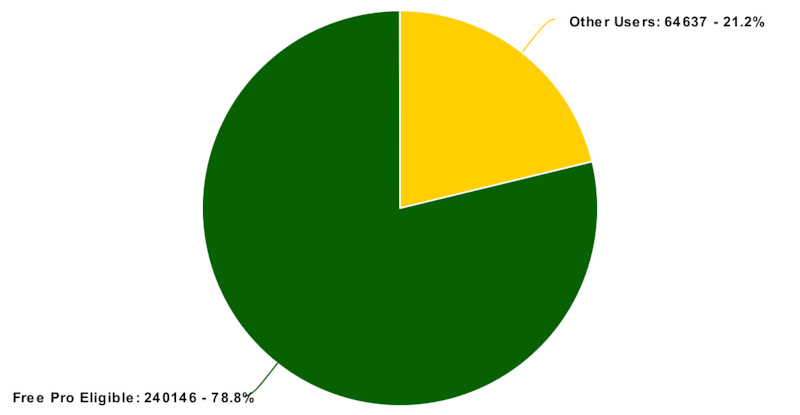
40,121 of the trails in the green pie area were directly added by Trailforks staff. And Trailforks staff are often involved with cleanup or moderation of many of the other trails.
Many apps in the trail or mapping space have a paid subscription models with lots of user contributed data, this is not out of the norm. AllTrails, Strava, Gia, ViewRanger, OnX are a few examples.
Access to other content that takes less effort than mapping trails like adding photos, reports, videos, comments and ridelogs are still freely available on the website and the app, free or pro.
| Used to be the best trail app, but having to pay to view trails outside a small area really brings it down. I wouldn't mind seeing ads for the whole thing but as of the recent update it really sucks. |
"If You're Not Paying for It, You're the Product"
I'm fairly certain we would have equal or more complaints if we added advertising to the app rather than a paid subscription. As outlined here, we had to monetize Trailforks to make it self-sustainable. Plastering the app and website with advertisements would severely diminish the user experience. Trailforks customer becomes the advertisers rather than you the rider. To maximize our revenue so we can pay our costs and build all the rad future things we have planned, we would have to optimize for advertising and the requests of advertisers. Joining the game of the "attention economy" with all the sneaky tricks the social media companies deploy to try and increase your usage time in their apps to get the most amount of ad views. We also don't want to collect and sell user data with advertisers. This is not a game we want to play, nor do we think most users want!
| Used to be good, now it's useless unless you get the pro version. |
The Trailforks website and mobile site are still free and accessible via a phone.
"Useless" is very much an exaggeration! As stated before, the map is greyed out beyond your free area, but trail lines are still visible for basic navigation. Your location it still shown on the map, you can still click a trail to view some basic stats and it's status on the map. But the vast majority of functionality that makes the Trailforks app a powerful tool and USEFUL is still available for free.
You can still...
- View and post trail reports including conditions
- View routes & user rides that include a selected trail
- View routes from search, wishlist, discover
- View top trails, routes, photos and personalized recommended routes for a region on the discover page
- Search for trails
- Record your ride
- View your own ridelogs and feed of friends rides
- View trail details like description, photos, videos, reports
- More trail detail page info like average time to ride trail, relative local popularity of trail, direction of trail, usage of trail
- View race routes
- Post photos for trails
- Log trail work.
- View all info on a region detail page (description, trails, routes, reports, photos, videos, events, rides)
- View events, contests, badges
- View regions trail status board
- View your location on the map
- Access the emergency page, and unlock the map in case of emergency 3 times
- View land owner overlay (find free BLM camping)
- View Strava segments on the map
- Save trails or routes to wishlist, rate trails, comment on trails
- Donate trail karma to trail associations
- Access winter map unrestricted
- Free use of the Trailforks website and mobile site
- Subscribe to Pro to get the full app map unlocked, pro only features and support continued development of Trailforks
| ...may also come to harm users who decide to pay when the amount of contributors diminishes |
In the 6 months since Pro was launched, every month has been record setting for the amount of new trails mapped to Trailforks. So rather than diminishing contributions, it has actually increased.

The amount of trails and other content being added has been increasing every year with a spike through 2020, so much so it's too much to manage for our small team. We require more staff to assist in moderating & contributing in-house content. We are confident the amount of contributions will continue to rise in the long term, as the growth of new users and app installs each day continues to grow. We are thinking about our next million downloads & users and how best to serve them with a better product and support through more resources funded by Pro revenue.
For contributed content like trail reports and conditions, most of the time reports are added by locals for their local trails. You can always view and submit reports on the app, free or Pro. Even with the free version of the app you can see the map fully inside your free home area, to submit reports. Additionally more reports are added via the Trailforks website than via the app, the website is unchanged and free access.
No other platform comes close to the robust features around trail reporting that Trailforks offers, this is still all free.
| We are not giving back to the trails |
We believe we do more than our fair share to give back to the trail community. We create and promote features like Trail Karma, focus development time creating free tools, data & statistics for trail associations. We provide them with a free map, print maps, management platform, widgets, free pro subscriptions, support and recognition.
Learn more about the benefits of Trailforks for trail associations.
Trailforks & Pinkbike also directly donates to our local trail orgs and helps with fundraising events and initiatives.
But we are going to do more!
We also have multiple ideas on how we can share some revenue, or give back directly to trail associations. There are a bunch of options and we are consulting some trail orgs. No timeline on the rollout of this, but we are working on it!
With more resources in the future from Pro revenue, we can make more tools targeting trail association and builder needs. With limited development staff, it's been hard to prioritize new tools and features that would benefit trail associations that are used by a small amount of users. Compared to working on a new feature or improving an existing general feature that targets the average rider.
Increasing Amount of In-House Content
Since introducing Trailforks Pro we have added a large amount of non user-generated content or in-house content. Along with Trailforks staff adding trail content ourselves we've added a range of new map layers created by Trailforks.
New layers include Jumps Heatmap, Activity Recordings, Elevation, Avalanche Risk, Avalanche Forecast, Air Quality, Percip Forecast, Snow Forecast, Current Fires, Smoke, USFS & MVUM trails
We will be investing in creating more data layers and in-house content increasing the value and utility of Trailforks. Additionally in the future we will integrate more content from other Outside brands.
Why We Created Trailforks Pro
We truly appreciate all the support of our users over the last five years that Trailforks has been free but in order to continue to be great, we have to start charging.
Every premium service has to find a way to pay the bills eventually, we had 3 options, plaster the website & app with advertising, charge trail associations, or charge users. We dislike ads and the tracking of users across the web it involves. We have never and don't want to sell user data, or even force users to have an account to use the app & website, thus tracking them even more. And one of the core missions of Trailforks is to provide tools and data for non-profit trail associations, so charging them doesn't align with that. So we decided on a reasonable yearly subscription for users, which can be purchased even without an account.
Every time the app is used, external services ( map tiles, Google maps, satellite imagery, elevation data, weather data, and more ) have a cost associated with it. We have been able to absorb the cost until now, but as more and more users use the app we just can't absorb this indefinitely. Then there are the costs of server hardware, bandwidth costs, staff salaries, events and so on.
We have tried to strike a balance between free access and a sustainable payment model. Our view is that users actively participate and contribute to Trailforks in their local areas, so that should be free. For users wanting access to Trailforks Pro worldwide, we hope they see enough value to spend the equivalent of a couple of post-ride beers at the pub.
The revenue from Trailforks Pro will enable us to hire more staff, develop additional features, provide better support, and improve our infrastructure. Subscribing to Trailforks Pro is your way of supporting Trailforks and it's continued improvement and operations. With your support, we’re excited to make Trailforks even better!

Lear more about how you can still use Trailforks for free.
Author Info:

 Member since Jun 8, 2010
Must Read This Week
Sign Up for the Pinkbike Newsletter - All the Biggest, Most Interesting Stories in your Inbox
PB Newsletter Signup
1 Comment
Comments are disabled for this article.