Switzerland for Dummies: Engadin-St Moritz - Part 4
Bryce, Sharon and Lee find out if there is lift serviced, all-mountain alpine singletrack epics in Switzerland. Follow them in this six part series as they document how a bunch of North Americans find their way around Switzerland.
Stay tuned each coming week for the next instalment of Switzerland for Dummies
|| Flims-Laax || Lenzerheide || Davos-Klosters || Engadin-St. Moritz || Zermatt || General Tips and Tricks ||
Chuchichäschtli
Engadin-St. Moritz: Introduction
It was the locals (thanks again to Swiss Alpine Adventure for more sage advice) again that steered us to the Engadin - St Moritz, a spot that wasn't originally on our radar due to its reputation for expensive hotels that cater to the Prada-clad set. The Engadin is a long valley in the southern end of Graubünden. It's about 100 km long; so long that we just took trains through the Northeastern part and never even got a chance to check out the Southwestern end. Instead we confined ourselves to travelling by bike and train through the major towns of Upper Engadin, including the world famous St. Moritz and lesser-known, but in my opinion more interesting towns of Spinas, Bever, Celerina, Pontresina and Poschiavo.
Proximity to Italy gives the Engadin (and in particular the Poschiavo region) a bit of a different flavour than the rest of the Graubünden areas that we previously visited. The influence of St. Moritz and its appeal to international visitors also seems to add to this difference. For the first time we heard some English and American/Canuck accents in the hotels.
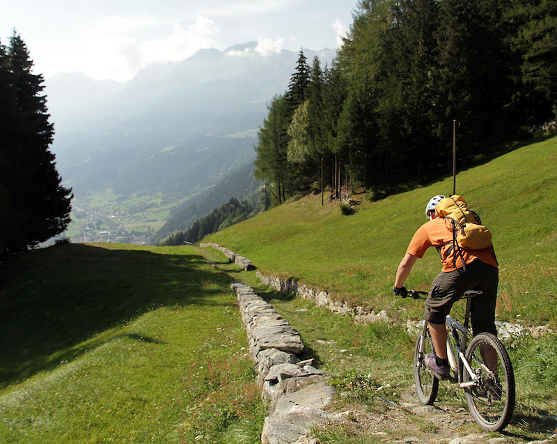
![Hundred year old roads and singletrack lead to Poschiavo from Cavaglia]()
Hundred year old roads and singletrack lead downhill to Poschiavo from Cavaglia.
Goin' down I Trailsurfing in the Engadine
Filmed by Tom Malecha of Zurich in the Engadin valley. Used with his kind permission
It turned out be a fantastic idea to visit the Engadin. It need hardly be said that getting there was easy. A train took us from Davos Platz to our connection to the Rhatische Bahn train on the Davos - Fillisur line. This is actually a slow, ponderous train that is set up mainly for tourism purposes to bring sightseers into the mountains. It's also used by many people as a way to travel back and forth in the mountains and we found it to be a great way to get to trailheads and cut out climbs, although be advised to carefully check schedules to ensure that you can bring your bikes on to the train at the times you want to travel.
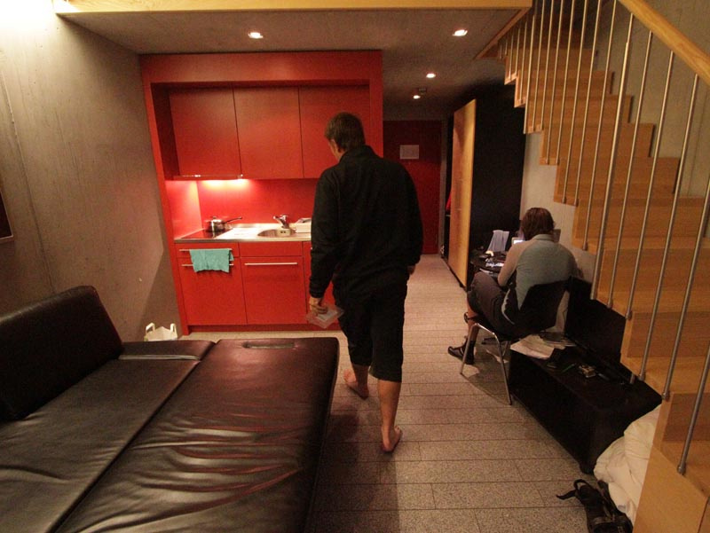
The Rhätische Bahn, aka RhB, was also our transport to the quiet little town of Celerina where we settled into yet another comfortable bike hotel, the Inn Lodge. The Inn Lodge was a bit of a contrast to the other bike hotels in which we stayed; having a bit more of a hostel feel to it. Clad in concrete, it does not have the historical feel of Kurhaus in Lenzerheide or Strela in Davos and lacks the coziness of a communal lounge, but did share the common traits of splendid breakfasts, secure bike storage, access to tools, and astounding location.
![The Inn Lodge is actually in Celerina not St. Moritz]()
The Inn Lodge is in Celerina.
![The Inn Lodge is actually in Celerina not St. Moritz]()
Interior of the Inn Lodge.
Location, location, location. It took us about five minutes of flat pedalling to get to the ski area of Corviglia/Piz Nair from the Inn Lodge. It takes two minutes of coasting to get to the RhB Celerina Staz station for the Bernina Express train from Inn Lodge. On that note, the RhB has many separate "lines" so take note of the exact station name where you must embark and check with the Tourism offices at stations if you have confusion, or check with the Inn Lodge front desk. The train station of Celerina Staz is a stop on the RhB Bernina line (not to be confused with Celerina Schlaringa which is the train station for RhB Davos-Fillisur line). The Bernina line is the gateway to destinations South, including Piz Bernina, which is a high-point and the start of many Routes that we've described below.
![The Marguns lift accesses lots of riding including the wonderful Suvretta Pass loop]()
The Marguns lift accesses a lot of riding, including the wonderful Suvretta Pass loop.
![Suvretta Pass to Spinas then to Bever and finally to Celerina - heavenly descent]()
Sharon on Suvretta Pass.
Despite its reputation for being touristy, the whole area (trails, towns, hotels, even the concrete high-rises of St Moritz) were not at all crowded. In particular it seemed that all the hotels in Graubunden where we stayed were eriely deserted, much like the hotel in "The Shining". The lift-served biking is so amazing, why doesn't everybody do this stuff? Where are all the people? Where are the hordes of Germans, Brits, or perhaps Americans? We are not pioneers by any means - the Swiss have been biking these trails for decades.
It turns out that there are a variety of reasons. We visited in September when things are a bit quieter as the end of the season approaches. In peak months you do need to book ahead and the trains (particularly the RhB) and trails will be a little more crowded. It also happens that the Euro-denominated currency economies are all committing mass suicide, and accordingly the Swiss Franc is at its all-time high as investors flee uncertainty (while we were there the Swiss federal bank made the futile gesture of attempting to devalue the CHF via currency intervention). Good for people holding CHF; not so good for tourism in Switzerland as a country that has a reputation for being a tad pricey becomes even more pricier due to exchange rates.
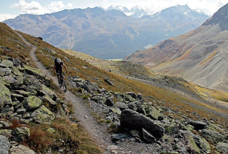
![Approaching Suvretta Pass]()
Approaching Suvretta Pass it might look like you're far away from everything.
![On the Suvretta Pass trail high above St Moritz]()
The reality is that even on Suvretta Pass, St Moritz and other population centres are not far away.
Even though there were never many people on the trails they are by no means deserted. In North America there are areas which are wilderness in the sense that you can be days, not just hours, from cell phone, roads, or help and you have to be self reliant. Not so in the Swiss areas where we went - emphasis added - we know full well our experience was limited. We would be pedalling at treeline in sub-alpine and would encounter bergrestaurants; a PostBus pulling into a stop and perhaps a RhB station. Definitely there are farms all over and the omnipresent chue. Even in alpine there will be the odd bergrestaurant and the ubiquitious consistent signage.
On reflection, this is not surprising. Switzerland as a whole is 41,285 square km. About 7.8m people live there. Compare this to, for example, Vancouver Island which is considered quite populated by Canadian standards (33,000 square km; about 750,000 people), or the states of Vermont and New Hampshire combined (48,000 square km; about 1.9m people combined). Swiss population density is greater than North American. Anecdotally, it seems that the Swiss are much more active than us fat-ass North Americans; we saw old, middle aged, young and toddlers "wanderwegging" all over the place. Entire families were out enjoying the mountains; very inspiring! History seems to be another reason. Swiss weren't always bankers and manufacturers of fine goods (watches, precision instruments, Toblerone), but were a nation of farmers. There isn't that much space in the valleys for crops and cows so many farmers made do with land in the mountains. Skiing and biking were recreational dalliances when the serious work of growing food to live could not be done due to the advent of winter. This meant a nation of people who have long standing experience with spending a lot of time in the mountains in forbidding environments and climates.
![The lift-served Alp Nova trail off the Chanteralla lift]()
The lift-served Alp Nova trail off the Chanteralla lift.
The results are a lot of infrastructure in mountainous regions, which id good in the sense that you're never really that far from some modicum of comforts or assistance. Bad in the sense that you can't really get away from it all. However, we knew and had researched this before we came to Switzerland and had expected shared trails and lots of facilities in places you might not otherwise expect. Accordingly, our riding had been targeted at touristy regions to get a taste for the alpine infrastructure. Additionally, one cannot resent sharing trails with other users (other bikers, hikers, dogwalkers etc alike) that are so mutually respectful and stoked. We've said it before but it bears mentioning that that Graubünden is one of the few cantons (Wallis is the other) that allow bikes on virtually all trails. Be respectful and friendly to other users so that it stays that way - most likely they will be all smiles anyway and saying gruezi, danke, morgen, or sometimes cheering you on and hollering “schnell, schnell!”
![We stop at Spinas for some refreshements]()
We stop at Restaurant Alp Spinas for some refreshments at 1950m.
Route Descriptions
ROUTE: Suvretta Pass - Spinas - Bever - click here for more pictures and video from our blog
Summary: This ride can easily be done in half a day, which was perfect as we got into Celerina from Davos and still managed to leisurely accomplish the ride in 5 hours. From Celerina take the Marguns lift and then ride up the ski hill roads to the Alpina Hutte. From there, the trail is very clearly signed to Suvretta Pass. At SuvrettaSee you can descend South towards Silvaplana (another town in Upper Engadin) via a highly recommended descent that we did not get around to doing. Alternatively you can descent North via lovely, not-too-steep and just-right flowy trails through the standard majestic alpine views to intersect the road which takes you to Alp Spinas. Then ride the road all the way to Bever and finish with the main highway back to Celerina. We have to rate this the top pure singletrack experience of any ride we did in Graubünden. There's a lot of road from Spinas to Celerina, but it's oh so worth it. Totals are 32.9km, 400m of climbing, 950m descending.
![Climbing from the lifts at Marguns in Celerina to Suvretta Pass]()
Climbing from the lifts at Marguns in Celerina to Suvretta Pass.
![Approaching Suvretta Pass]()
Approaching Suvretta Pass.
![600m of mostly singletrack descending from Suvretta to the Spinas road]()
600m of mostly singletrack descending from Suvretta to the Spinas - Bever road.
![600m of mostly singletrack descending from Suvretta to the Spinas road]()
Bryce on Suvretta Pass.
![Descent to Spinas]()
Descent to Spinas.
St. Moritz - Suvretta Pass at EveryTrail
ROUTE: Bernina Pass South to Poschiavo; Col D'Anzana to Tirano - click here for more pictures and video from our blog
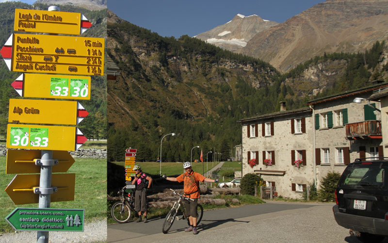
Summary: Pick up the Rhb at Celerina Staz and get off at Ospizio Bernina station. From there head South on the East shore of Lago Blanco following the shoreline trail. We then picked up another well-marked trail that wound in and out of the RhB traintracks to Alp Grum. After Alp Grum be aware there are some nasty waterbars formed out of chunky sharp rock that will cause an instant flat if you have a moment's inattention. Then follow very well signed trails to Cavaglia and to Poschiavo. You will keep thinking that the trail will turn from singletrack and doubletrack to road but it keeps winding in and out between classic old farmhouses and the traintracks, staying quite narrow. Pretty much the quintessential Swiss picture perfect ride. Note that just this leg alone is a decent ride and you can easily hop back on the RhB and head back to Celerina, or pop out back from the RhB and then ride Bernina - Pontresina - Celerina on some snooze-fest trails that are described below.
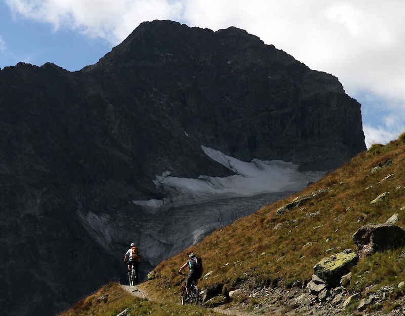
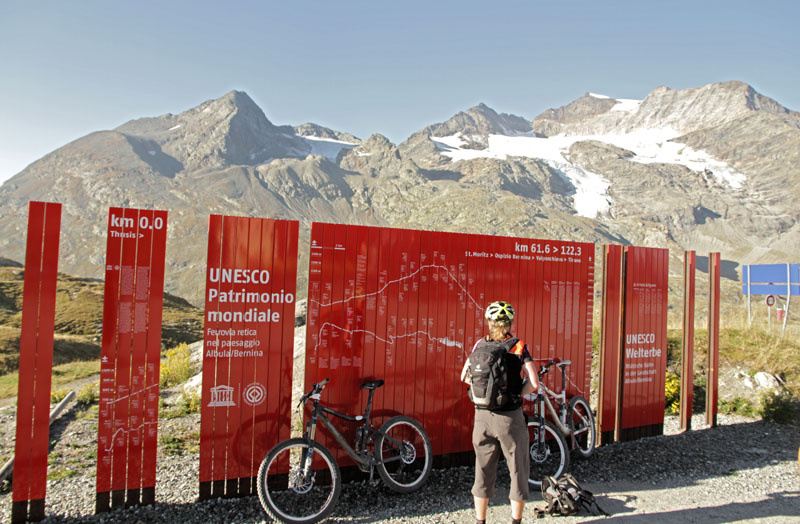
![Standard stunning Swiss views. This is of the Cambrena Glacier and Piz Cambrena 3606m]()
Standard stunning Swiss views. This is of the Cambrena Glacier and Piz Cambrena (3606m) from Bernina Pass close to the RhB Ospizio Bernina station.
![Lago Blanco at Bernina Pass]()
Lago Blanco at Bernina Pass.
![The town of Cavaglia and the remnants of the Palu Glacier on the road to Poschiavo]()
The town of Cavaglia and the remnants of the Palu Glacier on the road to Poschiavo.
Should you decide to do Col d'Anzana, you can either road-ride from 700m to 2200m Col D'anzana, or you can do what fat, lazy North Americans do and hire a car-shuttle which will take you from Poschiavo to Pescaa Bassa (1830m) and climb the rest of the way. We elected to hire a driver (40 CHF each - Patrick - +41 (0)81 844 10 42). Directions are well signed to Anzana and really there is little to go wrong down the trail. Anzana to Tirano starts out well as it traverses and gradually and interestingly loses elevation. Unfortunately, the middle and bottom parts of the trail then start becoming annoyingly steep, Splitting into a trail and road, with the trail being smooth rock-armoured artless descending where you hang your ass on your back wheel and grab brake levers with the entire fist. The trail becomes road at about 800m and you can then descend to Tirano where you can easily find the RhB station to take you back to Celerina. All is forgiven of the trail, though, as Tirano food is wonderful!
I have mixed feelings about this ride. The first leg (Bernina to Poschiavo) was very worthwhile, with stunning views and a great descent. The second leg (Col d'Anzana to Tirano) was an artless, too steep descent on manmade boring trails that lacked flow. Sharon and Bryce did not share my negativity, but keep the elevation profiles in mind. Personally, I'd recommend doing the first leg and skipping the second. Ride totals are 62.2km distance, 1500m descent (Bernina to Poschiavo); 1800m descent (Anzana to Tirano)
![Crossing the Swiss-Italian border and starting the 2000m descent of Col D Anzana]()
Crossing the Swiss-Italian border and starting the 2000m descent of Col D'Anzana.
![Looking down on Poschiavo in Switzerland from Italy. We re still 400m above Tirano in Italy.]()
Looking down on Poschiavo in Switzerland from Italy. We're still 400m above Tirano in Italy.
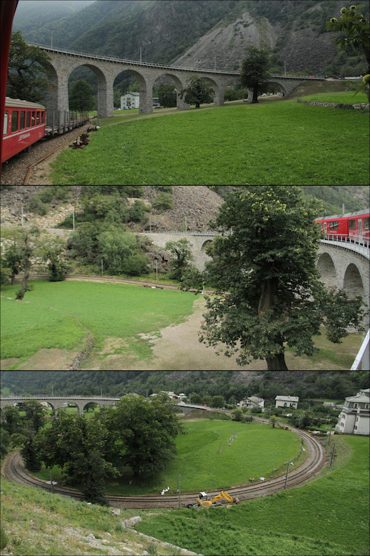
![Those Swiss Engineered spiral rail bridges on the Rhaetische Bahn]()
Those Swiss! Engineered spiral rail bridges on the Rhaetische Bahn.
Bernina pass to Poschiavo to Tirano viacoldanzana at EveryTrail
ROUTE: Bernina Pass North to - Pontresina - St Moritz. Chantarella lift and Alp Nova - click here for more pictures and video from our blog
Summary: The first leg (Bernina to St Moritz or Bernina North) could easily be combined with the Bernina to Poschiavo route, or Bernina South, mentioned above. Simply take the RhB back to Ospizio Bernina after your descent to avoid the climb back up.
The first leg is very mellow. The slope gradient should tell all you know as it is pretty much double track, albeit with the standard fantastic views, from Bernina and then past the Diavolezza gondola bottom to Alp Grum on a trail that parallels the highway. Not the most interesting trail to be perfectly honest. Many people elect for the exercise and ride up from Alp Grum to Bernina so watch out for two way bike and hiking traffic. The trail gets a bit more interesting and narrow past Alp Grum as it descends through the woods and winds its way to Pontresina. As you get closer to Pontresina there will be significantly more traffic. The trail then becomes double-track, pine-needled and gets smoother. Enthusiasm should be restrained as there are many blind corners and lots of walking traffic in that section. From there the exceptionally well-signed double-track is easy to navigate to St. Moritz, or to Celerina depending on preference.
The second leg was exceptional. Up till now, most Graubunden lift-served trails have been very technical. Flowy, but abrupt switchbacks with surprises (holes, waterbars, chue presents etc) in random spots so you couldn't really let the speed go. We spied Alp Nova from the lift and it was so good that we decided to do it twice. Truly a gem and the best lift-served trail we did by far in Switzerland, perhaps the best lift-served trail I've ever done anywhere in the world. However, you should do yourself a favour and skip the last part of our GPS track and just road-ride from St Moritz to Celerina as the trail we had scoped out climbed steeply to a Swisscom cell tower then wasted all its elevation on road. As you might see from our description, don't waste your time on the rather mediocre first leg. Instead, spend more time exploring the trails accessed off the Chantarella. The day added up to 23.6km; 550m descent (Bernina - North to St Moritz leg); 7.3km; 520m (Chantarella - Alp Nova mid station, Corviglia station - each lap).
![More lift-served riding ho hum]()
Chantarella Bahn: More lift-served riding ho hum.
![The lift-served Alp Nova trail off the Chanteralla lift]()
The lift-served Alp Nova trail.
![The lift-served Alp Nova trail off the Chanteralla lift]()
Alp Nova.
St. Moritz - Bernina pass funicular laps at EveryTrail
By Sharon Bader, Bryce Borlick and Lee Lau. Maps by Sharon, photos and video by Lee unless otherwise noted
Stay tuned each coming week for the next instalment of Switzerland for Dummies
|| Flims-Laax || Lenzerheide || Davos-Klosters || Engadin-St. Moritz || Zermatt || General Tips and Tricks ||
Chuchichäschtli
Engadin-St. Moritz: Introduction
It was the locals (thanks again to Swiss Alpine Adventure for more sage advice) again that steered us to the Engadin - St Moritz, a spot that wasn't originally on our radar due to its reputation for expensive hotels that cater to the Prada-clad set. The Engadin is a long valley in the southern end of Graubünden. It's about 100 km long; so long that we just took trains through the Northeastern part and never even got a chance to check out the Southwestern end. Instead we confined ourselves to travelling by bike and train through the major towns of Upper Engadin, including the world famous St. Moritz and lesser-known, but in my opinion more interesting towns of Spinas, Bever, Celerina, Pontresina and Poschiavo.
Proximity to Italy gives the Engadin (and in particular the Poschiavo region) a bit of a different flavour than the rest of the Graubünden areas that we previously visited. The influence of St. Moritz and its appeal to international visitors also seems to add to this difference. For the first time we heard some English and American/Canuck accents in the hotels.

It turned out be a fantastic idea to visit the Engadin. It need hardly be said that getting there was easy. A train took us from Davos Platz to our connection to the Rhatische Bahn train on the Davos - Fillisur line. This is actually a slow, ponderous train that is set up mainly for tourism purposes to bring sightseers into the mountains. It's also used by many people as a way to travel back and forth in the mountains and we found it to be a great way to get to trailheads and cut out climbs, although be advised to carefully check schedules to ensure that you can bring your bikes on to the train at the times you want to travel.
The Rhätische Bahn, aka RhB, was also our transport to the quiet little town of Celerina where we settled into yet another comfortable bike hotel, the Inn Lodge. The Inn Lodge was a bit of a contrast to the other bike hotels in which we stayed; having a bit more of a hostel feel to it. Clad in concrete, it does not have the historical feel of Kurhaus in Lenzerheide or Strela in Davos and lacks the coziness of a communal lounge, but did share the common traits of splendid breakfasts, secure bike storage, access to tools, and astounding location.

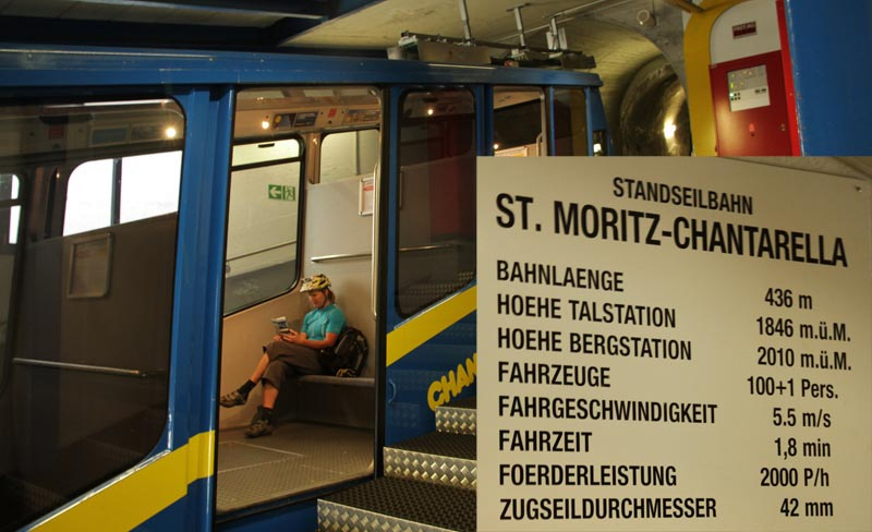
Location, location, location. It took us about five minutes of flat pedalling to get to the ski area of Corviglia/Piz Nair from the Inn Lodge. It takes two minutes of coasting to get to the RhB Celerina Staz station for the Bernina Express train from Inn Lodge. On that note, the RhB has many separate "lines" so take note of the exact station name where you must embark and check with the Tourism offices at stations if you have confusion, or check with the Inn Lodge front desk. The train station of Celerina Staz is a stop on the RhB Bernina line (not to be confused with Celerina Schlaringa which is the train station for RhB Davos-Fillisur line). The Bernina line is the gateway to destinations South, including Piz Bernina, which is a high-point and the start of many Routes that we've described below.


Despite its reputation for being touristy, the whole area (trails, towns, hotels, even the concrete high-rises of St Moritz) were not at all crowded. In particular it seemed that all the hotels in Graubunden where we stayed were eriely deserted, much like the hotel in "The Shining". The lift-served biking is so amazing, why doesn't everybody do this stuff? Where are all the people? Where are the hordes of Germans, Brits, or perhaps Americans? We are not pioneers by any means - the Swiss have been biking these trails for decades.
It turns out that there are a variety of reasons. We visited in September when things are a bit quieter as the end of the season approaches. In peak months you do need to book ahead and the trains (particularly the RhB) and trails will be a little more crowded. It also happens that the Euro-denominated currency economies are all committing mass suicide, and accordingly the Swiss Franc is at its all-time high as investors flee uncertainty (while we were there the Swiss federal bank made the futile gesture of attempting to devalue the CHF via currency intervention). Good for people holding CHF; not so good for tourism in Switzerland as a country that has a reputation for being a tad pricey becomes even more pricier due to exchange rates.

Even though there were never many people on the trails they are by no means deserted. In North America there are areas which are wilderness in the sense that you can be days, not just hours, from cell phone, roads, or help and you have to be self reliant. Not so in the Swiss areas where we went - emphasis added - we know full well our experience was limited. We would be pedalling at treeline in sub-alpine and would encounter bergrestaurants; a PostBus pulling into a stop and perhaps a RhB station. Definitely there are farms all over and the omnipresent chue. Even in alpine there will be the odd bergrestaurant and the ubiquitious consistent signage.
On reflection, this is not surprising. Switzerland as a whole is 41,285 square km. About 7.8m people live there. Compare this to, for example, Vancouver Island which is considered quite populated by Canadian standards (33,000 square km; about 750,000 people), or the states of Vermont and New Hampshire combined (48,000 square km; about 1.9m people combined). Swiss population density is greater than North American. Anecdotally, it seems that the Swiss are much more active than us fat-ass North Americans; we saw old, middle aged, young and toddlers "wanderwegging" all over the place. Entire families were out enjoying the mountains; very inspiring! History seems to be another reason. Swiss weren't always bankers and manufacturers of fine goods (watches, precision instruments, Toblerone), but were a nation of farmers. There isn't that much space in the valleys for crops and cows so many farmers made do with land in the mountains. Skiing and biking were recreational dalliances when the serious work of growing food to live could not be done due to the advent of winter. This meant a nation of people who have long standing experience with spending a lot of time in the mountains in forbidding environments and climates.

The results are a lot of infrastructure in mountainous regions, which id good in the sense that you're never really that far from some modicum of comforts or assistance. Bad in the sense that you can't really get away from it all. However, we knew and had researched this before we came to Switzerland and had expected shared trails and lots of facilities in places you might not otherwise expect. Accordingly, our riding had been targeted at touristy regions to get a taste for the alpine infrastructure. Additionally, one cannot resent sharing trails with other users (other bikers, hikers, dogwalkers etc alike) that are so mutually respectful and stoked. We've said it before but it bears mentioning that that Graubünden is one of the few cantons (Wallis is the other) that allow bikes on virtually all trails. Be respectful and friendly to other users so that it stays that way - most likely they will be all smiles anyway and saying gruezi, danke, morgen, or sometimes cheering you on and hollering “schnell, schnell!”


ROUTE: Suvretta Pass - Spinas - Bever - click here for more pictures and video from our blog
Summary: This ride can easily be done in half a day, which was perfect as we got into Celerina from Davos and still managed to leisurely accomplish the ride in 5 hours. From Celerina take the Marguns lift and then ride up the ski hill roads to the Alpina Hutte. From there, the trail is very clearly signed to Suvretta Pass. At SuvrettaSee you can descend South towards Silvaplana (another town in Upper Engadin) via a highly recommended descent that we did not get around to doing. Alternatively you can descent North via lovely, not-too-steep and just-right flowy trails through the standard majestic alpine views to intersect the road which takes you to Alp Spinas. Then ride the road all the way to Bever and finish with the main highway back to Celerina. We have to rate this the top pure singletrack experience of any ride we did in Graubünden. There's a lot of road from Spinas to Celerina, but it's oh so worth it. Totals are 32.9km, 400m of climbing, 950m descending.


ROUTE: Bernina Pass South to Poschiavo; Col D'Anzana to Tirano - click here for more pictures and video from our blog
Summary: Pick up the Rhb at Celerina Staz and get off at Ospizio Bernina station. From there head South on the East shore of Lago Blanco following the shoreline trail. We then picked up another well-marked trail that wound in and out of the RhB traintracks to Alp Grum. After Alp Grum be aware there are some nasty waterbars formed out of chunky sharp rock that will cause an instant flat if you have a moment's inattention. Then follow very well signed trails to Cavaglia and to Poschiavo. You will keep thinking that the trail will turn from singletrack and doubletrack to road but it keeps winding in and out between classic old farmhouses and the traintracks, staying quite narrow. Pretty much the quintessential Swiss picture perfect ride. Note that just this leg alone is a decent ride and you can easily hop back on the RhB and head back to Celerina, or pop out back from the RhB and then ride Bernina - Pontresina - Celerina on some snooze-fest trails that are described below.

Should you decide to do Col d'Anzana, you can either road-ride from 700m to 2200m Col D'anzana, or you can do what fat, lazy North Americans do and hire a car-shuttle which will take you from Poschiavo to Pescaa Bassa (1830m) and climb the rest of the way. We elected to hire a driver (40 CHF each - Patrick - +41 (0)81 844 10 42). Directions are well signed to Anzana and really there is little to go wrong down the trail. Anzana to Tirano starts out well as it traverses and gradually and interestingly loses elevation. Unfortunately, the middle and bottom parts of the trail then start becoming annoyingly steep, Splitting into a trail and road, with the trail being smooth rock-armoured artless descending where you hang your ass on your back wheel and grab brake levers with the entire fist. The trail becomes road at about 800m and you can then descend to Tirano where you can easily find the RhB station to take you back to Celerina. All is forgiven of the trail, though, as Tirano food is wonderful!
I have mixed feelings about this ride. The first leg (Bernina to Poschiavo) was very worthwhile, with stunning views and a great descent. The second leg (Col d'Anzana to Tirano) was an artless, too steep descent on manmade boring trails that lacked flow. Sharon and Bryce did not share my negativity, but keep the elevation profiles in mind. Personally, I'd recommend doing the first leg and skipping the second. Ride totals are 62.2km distance, 1500m descent (Bernina to Poschiavo); 1800m descent (Anzana to Tirano)


ROUTE: Bernina Pass North to - Pontresina - St Moritz. Chantarella lift and Alp Nova - click here for more pictures and video from our blog
Summary: The first leg (Bernina to St Moritz or Bernina North) could easily be combined with the Bernina to Poschiavo route, or Bernina South, mentioned above. Simply take the RhB back to Ospizio Bernina after your descent to avoid the climb back up.
The first leg is very mellow. The slope gradient should tell all you know as it is pretty much double track, albeit with the standard fantastic views, from Bernina and then past the Diavolezza gondola bottom to Alp Grum on a trail that parallels the highway. Not the most interesting trail to be perfectly honest. Many people elect for the exercise and ride up from Alp Grum to Bernina so watch out for two way bike and hiking traffic. The trail gets a bit more interesting and narrow past Alp Grum as it descends through the woods and winds its way to Pontresina. As you get closer to Pontresina there will be significantly more traffic. The trail then becomes double-track, pine-needled and gets smoother. Enthusiasm should be restrained as there are many blind corners and lots of walking traffic in that section. From there the exceptionally well-signed double-track is easy to navigate to St. Moritz, or to Celerina depending on preference.
The second leg was exceptional. Up till now, most Graubunden lift-served trails have been very technical. Flowy, but abrupt switchbacks with surprises (holes, waterbars, chue presents etc) in random spots so you couldn't really let the speed go. We spied Alp Nova from the lift and it was so good that we decided to do it twice. Truly a gem and the best lift-served trail we did by far in Switzerland, perhaps the best lift-served trail I've ever done anywhere in the world. However, you should do yourself a favour and skip the last part of our GPS track and just road-ride from St Moritz to Celerina as the trail we had scoped out climbed steeply to a Swisscom cell tower then wasted all its elevation on road. As you might see from our description, don't waste your time on the rather mediocre first leg. Instead, spend more time exploring the trails accessed off the Chantarella. The day added up to 23.6km; 550m descent (Bernina - North to St Moritz leg); 7.3km; 520m (Chantarella - Alp Nova mid station, Corviglia station - each lap).

By Sharon Bader, Bryce Borlick and Lee Lau. Maps by Sharon, photos and video by Lee unless otherwise noted
Author Info:
 Member since Oct 18, 2009
Must Read This Week
Sign Up for the Pinkbike Newsletter - All the Biggest, Most Interesting Stories in your Inbox
PB Newsletter Signup
www.pinkbike.com/video/235751
bucket list today: 1- dive with great whites. 2- mountain bike Switzerland.
Sry but that's just Gay !