Stories posted under Pinkbike Community blogs are not edited, vetted, or approved by the Pinkbike editorial team. These are stories from Pinkbike users.
If a blog post is offensive or violates the Terms of Services, please report the blog to Community moderators.
Trailforks App Free Usage Changes
We have been listening to user feedback the past 3 years about the free user usage of the Trailforks app. We had an untraditional paywall where you could set ONE small free area and anything beyond that the map & trails were greyed out, making it pretty hard to use for basic map and navigation.
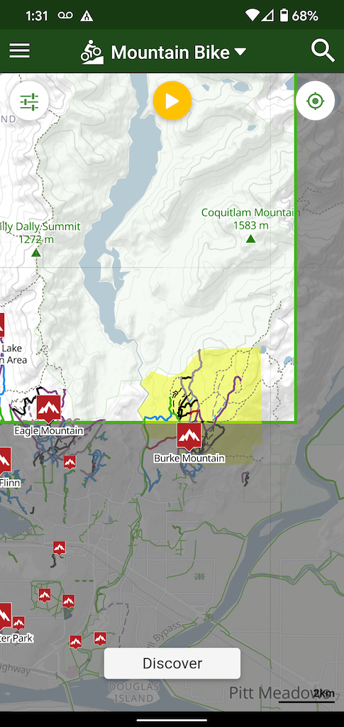
BEFORE
![photo]()
![photo]()
We heard the feedback that bike shops & trail associations had a harder time recommending Trailforks to visitors & new riders, cause if they didn't pay, they couldn't see the map.
So we are opening up free basic usage of the map, too a much larger area, your entire state or country. The map will no longer be greyed out, you can see the basic topo map, trails & POI for 1 downloaded region.
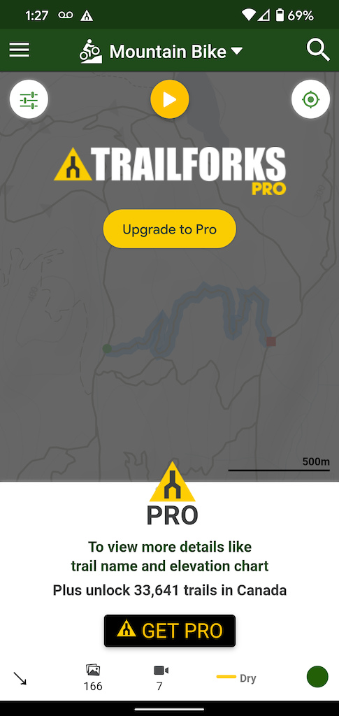
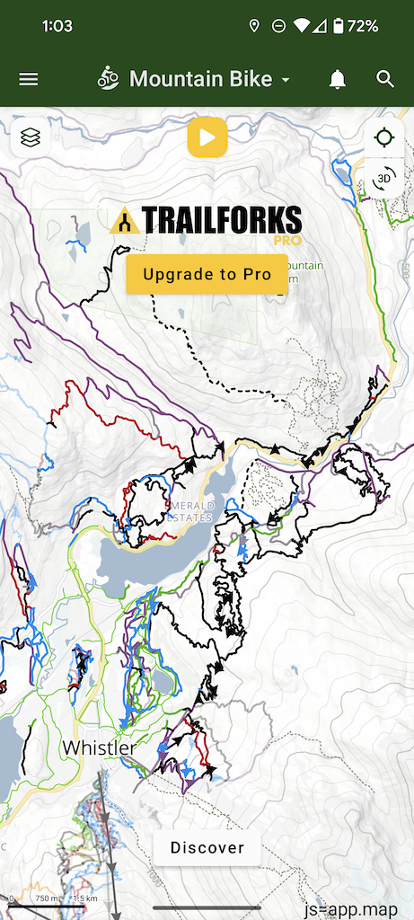
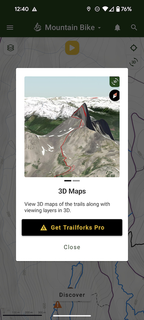
The tradeoff is much of the features beyond that basic map are now paywalled. You will need to subscribe to Trailforks Pro to get access to all the features and data in the app & website. Features like the heatmap, offline search, 3D maps and much more.
AFTER
![photo]()
![photo]()
As a free user you will still have limited access to content beyond the map such as trail reports, photos and videos.
As a free user you can always record your rides, view your rides, and contribute trail reports, photos comments and ratings.
We hope that users find enough value in the wide array of features Trailforks offers to subscribe to Trailforks Pro. But if that is not in your current budget, or you only need light basic map usage, you can now get more map content as a free user. We rather have users still using the app as a free user and maybe occasionally contributing to the community with trail reports or photos, than turn people away because the map is greyed out.
There is a "Trailforks Pro" banner on the map as a free user, you can "x" to close it for 30 days at a time. This banner has always been there, but you didn't see it in while in your free area. You are also limited to 1 downloaded region at a time, so if you travel out of state, you will have to upgrade to Trailforks Pro, or remove and download another region.
![photo]()
------------------------------------------------------------
Here is a breakdown of the features & functionality available as a Free user and Trailforks Pro user.
TRAILFORKS PRO
Unlimited region downloads
Offline map downloads (tiles)
Premium basemaps (Gaia, ArcGis, Satellite)
Map layers (inc heatmap, activities, strava, weather, fire)
Map trail styles (inc popularity)
Map filters
3D map
Trail & route elevation chart with grade visualization
Full details for trail, region, poi & skillpark pages
Route to trail function
Discover feature
View routes on map from Discover
Personal Wishlist for trails, routes, regions
Personal waypoints
Download GPX files
View weather information
Global offline Search
View all comments
View all trail reports
View all photos & videos
View personal ridelog stats
Search personal ridelogs
Status board
Google driving directions
Map "compass mode"
Sort and filter trail & route lists
Traildar
Live Location Sharing
WEBSITE PRO
Map layers (inc heatmap, activities, Strava, weather)
Map trail styles (inc popularity)
Change basemaps (Satellite, Gaia, OSM)
3D map
Route Finder unlimited results (free limit 3)
Trail usage statistics
Unlimited personal wishlist items
Download GPX
Garmin basemaps
Custom high resolution Print maps
Save map views & collections
Weather map
Road trip planner
Strava segments
Trail reports map
Priority in Strava & Garmin sync queues
Pro icon on your user avatar
BEFORE
We heard the feedback that bike shops & trail associations had a harder time recommending Trailforks to visitors & new riders, cause if they didn't pay, they couldn't see the map.
So we are opening up free basic usage of the map, too a much larger area, your entire state or country. The map will no longer be greyed out, you can see the basic topo map, trails & POI for 1 downloaded region.
The tradeoff is much of the features beyond that basic map are now paywalled. You will need to subscribe to Trailforks Pro to get access to all the features and data in the app & website. Features like the heatmap, offline search, 3D maps and much more.
AFTER
As a free user you will still have limited access to content beyond the map such as trail reports, photos and videos.
As a free user you can always record your rides, view your rides, and contribute trail reports, photos comments and ratings.
We hope that users find enough value in the wide array of features Trailforks offers to subscribe to Trailforks Pro. But if that is not in your current budget, or you only need light basic map usage, you can now get more map content as a free user. We rather have users still using the app as a free user and maybe occasionally contributing to the community with trail reports or photos, than turn people away because the map is greyed out.
There is a "Trailforks Pro" banner on the map as a free user, you can "x" to close it for 30 days at a time. This banner has always been there, but you didn't see it in while in your free area. You are also limited to 1 downloaded region at a time, so if you travel out of state, you will have to upgrade to Trailforks Pro, or remove and download another region.

------------------------------------------------------------
Here is a breakdown of the features & functionality available as a Free user and Trailforks Pro user.
FREE USER
See your location on the map
Limit to 1 downloaded region at a time
TF topo, satellite, osm basemaps
View trails, POI, regions and shared routes on the 2d map
View 2 recent trail reports on a trail or region
View 10 nearby reports
Submit trail reports
Submit trail photos
Submit trail comments
Rate trails
Save activity recordings (ridelogs)
View your personal activities (ridelogs)
Share links to content
View badges and contests
Badge participation
View events
Access emergency info screen
Change map activity type
View basic trail details
View 2 trail photos and videos
View 2 most recent comments on trails
TRAILFORKS PRO
Unlimited region downloads
Offline map downloads (tiles)
Premium basemaps (Gaia, ArcGis, Satellite)
Map layers (inc heatmap, activities, strava, weather, fire)
Map trail styles (inc popularity)
Map filters
3D map
Trail & route elevation chart with grade visualization
Full details for trail, region, poi & skillpark pages
Route to trail function
Discover feature
View routes on map from Discover
Personal Wishlist for trails, routes, regions
Personal waypoints
Download GPX files
View weather information
Global offline Search
View all comments
View all trail reports
View all photos & videos
View personal ridelog stats
Search personal ridelogs
Status board
Google driving directions
Map "compass mode"
Sort and filter trail & route lists
Traildar
Live Location Sharing
WEBSITE PRO
Map layers (inc heatmap, activities, Strava, weather)
Map trail styles (inc popularity)
Change basemaps (Satellite, Gaia, OSM)
3D map
Route Finder unlimited results (free limit 3)
Trail usage statistics
Unlimited personal wishlist items
Download GPX
Garmin basemaps
Custom high resolution Print maps
Save map views & collections
Weather map
Road trip planner
Strava segments
Trail reports map
Priority in Strava & Garmin sync queues
Pro icon on your user avatar
Author Info:

 Member since Mar 25, 2014
Must Read This Week
Sign Up for the Pinkbike Newsletter - All the Biggest, Most Interesting Stories in your Inbox
PB Newsletter Signup
0 Comments
Comments are disabled for this article.