Watch
Learn
Velo
BikeReg
Gaia GPS
Trailforks
Outside+
Pinkbike.com
Log in
Register
New User
News
Originals
Podcast
Reviews
Events
First Looks
Friday Fails
PB Racing
Tech
BuySell
Community
Forums
Community Blogs
Photos
Videos
Travel
Places
Trailforks
Places Directory
Shop
More
Travel
Forums
Blogs
Photos
Videos
Directory
Trailforks
Add to Favorites
Make feature
You must login to Pinkbike.
Don't have an account?
Sign up
Join Pinkbike
Login
Tweet
Share
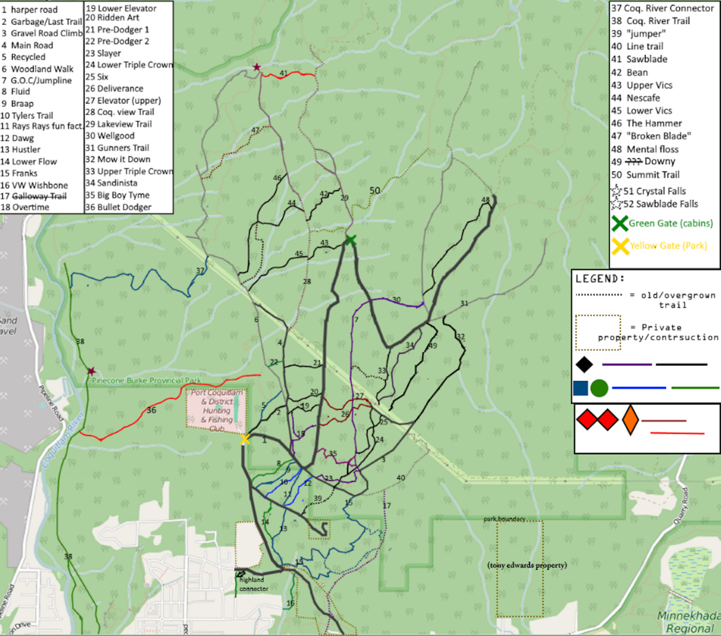
first update, i will redo the whole map soon and make a higher res. version
Currently browsing:
maps
Photo 1 of 2
Prev
Next
604freerider
O+
Follow
Following
1,439
Views
6
Comments
10
Favs
Photo info
Album
maps
Category
Scenery/Location
Date Posted
Jul 28, 2016 at 18:04
Jul 28, 2016
Location
Port Coquitlam, British Columbia, Canada
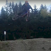
Trail
Flow
Riders
Burke map v2
Photo details
Photo Size:
Fill Window
Fill Window
Thumb
150 x 132
Small
250 x 221
Medium
500 x 441
Normal
800 x 706
Large
1024 x 903
Original
1104 x 974
Camera
unknown unknown
6 Comments
Score
Time
Who Faved
4
0
DK00
(Aug 1, 2016 at 21:31)
you are so amazing bro! great work!
[Reply]
2
0
604freerider
(Aug 1, 2016 at 21:42)
Thanks alot bro. the final version is coming out soon
[Reply]
1
0
brushyrush
(Sep 12, 2016 at 18:17)
bullet dodger
#1
[Reply]
1
0
Lifthero
(Sep 14, 2016 at 21:41)
Flywheel no more?
[Reply]
1
0
604freerider
(Sep 19, 2016 at 12:14)
i didnt bother including it. it has been destroyed by clearcutting. and where it used to be is now just houses
[Reply]
1
0
oesk1
(Sep 17, 2016 at 7:58)
thank you !!
[Reply]
Post a Comment
Login
or
Sign Up
About Us
Contacts
FAQ
Terms of Use
Privacy Policy
Sign Up!
Sitemap
Advertise
Advertising
Cool Features
Submit a Story
Product
Photos
Videos
Privacy Request
Manage Cookie Preferences
RSS
Pinkbike RSS
Pinkbike Twitter
Pinkbike Facebook
Pinkbike Youtube
Copyright © 2000 - 2023. Pinkbike.com. All rights reserved.
dv65 0.022917
Mobile Version of Website