Stories posted under Pinkbike Community blogs are not edited, vetted, or approved by the Pinkbike editorial team. These are stories from Pinkbike users.
If a blog post is offensive or violates the Terms of Services, please report the blog to Community moderators.
Your Guide to Viewing the Great North American Eclipse

On April 8, 2024, something truly epic is happening: a once-in-a-lifetime total solar eclipse over Mexico, the USA, and Canada (The Great North American Eclipse). Anticipation will be sky-high, so our map wizards have cooked up something extra-special for you: your very own Eclipse Layer, that incorporates NASA-curated data, allowing you to pinpoint the optimal locations to catch this event.
As the moon passes between the sun and Earth, it will cast a shadow, creating a path of totality where the sun is completely obscured. This path stretches from Mexico, through the United States, and up into Canada, offering a rare opportunity for millions to witness. It's a rare event that almost everyone in North America will be able to see, so with that being said, the Outside team is getting pumped and planning ahead!

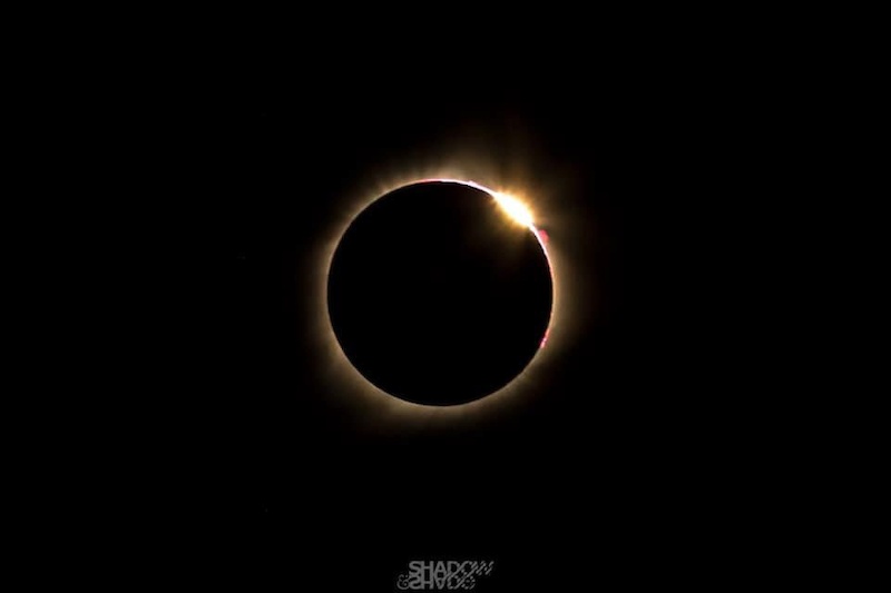
Photo credit: Shawdow and Shade Photography
The eclipse layer shows the path of totality and when it will peak on April 8, 2024, indicated by the pink circles. Color-coded bands on either side illustrate the percent of the sun that will be obscured by the moon. The duration of totality will be up to 4 minutes and 27 seconds, almost double that of The Great American Eclipse of August 21, 2017.
The North American Eclipse map is free to everyone with a Trailforks account. Here's how to use it:

1. Go to the Trailforks website.
2. Enable the Eclipse Layer: Look for the layer in the map's layers menu and select it to activate.
3. Pinpoint the Path of Totality. Use the layer to find the path where the sun will be completely obscured.
4. Pair the Eclipse Layer with info on public lands. We want you to get the best experience possible. This combo will help you pinpoint the perfect spots for watching the eclipse, whether you're up for a quick ride to the nearest park or a full-on adventure deep into the backcountry.
5. Plan your route. Using the eclipse map and your basemap of choice, map out your route by bike or on foot to find a prime viewing spot that works for you. Look for high points, clearings, and places with less chance of being clouded over.
6. Mark your destination by dropping a waypoint on the map. Download the map for offline use just in case, and navigate your way to your prime viewing spot.
7. Don't forget a pair of eclipse glasses (SUNoculars): they're the perfect shade for watching this event unfold.
Todd Neumarker - Trailforks' own Technical Director shares his last eclipse experience:
 | Riding during the eclipse is weird, because the shadows look strange and there is a glowing effect. It feels a bit like you're riding under stadium lights. I expected the weather to warm up in the morning, but the eclipse was at 10:30am, and around 10am the campsite temperature started to change direction and get cold again. The sun is what warms up the campsite in the morning, so the same principle applies. If the sun gets covered, the temperature dropped fast. I was unprepared and freezing for the first 30min of the ride and wished I had an app like Trailforks with this layer, because once I was off grid, I couldn't remember exactly what time it would hit in reference to where the campsite was. |

Photo credit: Shawdow and Shade Photography
| As I parsed through the NASA data, they used a variable to describe the percentage of coverage outside of the Path of Totality. They called it the "obscuratio". I don't think it is a real word, but given NASA's history, I somehow felt like if anyone could invent a word it would be those that work on the "final frontier." - Todd Neumarker |
While the Eclipse Layer is only available on the Trailforks website and is temporary, we'd like to highlight a few regions and trails that would be great places to watch the eclipse:
- Arkansas, Little Rock Area.
- Bentonville is not right in the path but close to get a partial viewing.
- Erwin Park, McKinney Texas (a great place to hang out at the park, ride, camp, and see the eclipse).
- For the roadies in Texas, the "Northeast Texas Trail" is recommended.
Major cities inside the path are:
Mazatlán, Mexico - 12:08 p.m. local time
Durango, Mexico - 12:17 p.m. local time
Austin, Texas - 1:18 p.m. local time
Dallas, Texas - 1:19 p.m. local time
Little Rock, Arkansas - 1:24 p.m. local time
St. Louis, Missouri - 1:27 p.m. local time
Indianapolis, Indiana - 2:22 p.m. local time
Cleveland, Ohio - 3:01 p.m. local time
Buffalo, New York - 3:14 p.m. local time
Montreal, Canada - 3:29 p.m. local time
This eclipse layer reveals that only a narrow strip of land will witness full totality, with surrounding areas being able to witness a partial eclipse. So mark your calendars, plan your route, and get ready to witness the Great North American Eclipse with us - it'll be totality worth it!
Author Info:
 Member since Sep 4, 2018
Must Read This Week
Rider List Announced & (Terrifying) Course Updates Teased for Red Bull Hardline Wales 2024
57328 views
57328 views
Sign Up for the Pinkbike Newsletter - All the Biggest, Most Interesting Stories in your Inbox
PB Newsletter Signup
0 Comments
Login or Sign Up