Biking in Northern Canada: the Yukon's Arctic Circle
Introduction
Margaret from Old Crow (look it up; village of 267 people in Northern Yukon) looks at me a bit taken aback. I repeat myself "We're going to try to ride up Surfbird. What do you think?". "Well ..." she says carefully. "I suppose just because no-one's done it doesn't mean it can't be done."
We're on the Dempster Highway; which begins in Central Yukon and ends at the Beaufort Sea on the Arctic Ocean. Margaret's been working at the Tombstone Territorial Park Visitor Centre for quite a few years. Lots of hikers and looky-look drivers stop by on their way along the Dempster Highway as does the odd touring cyclist. But Sharon and I are looking to mountain-bike. And that makes us, relatively speaking, strangers in a strange land.
Backing up a bit, a few years ago we traveled to the Yukon to bike in the Whitehorse area and to hike in the Tombstones. This happened in July and we were told that fall colours in the Arctic tundra would blow our minds. This got my exploration juices flowing and me thinking. It's just a wee drive of 3,000kms to get from Vancouver to Whitehorse then another 1100kms to the North West Territories (NWT) border.... hmm I wonder if there's biking opportunities along the way?
Plans were hatched, research was done (nope there's no reports about biking off the Dempster Highway), maps were consulted, Google Earth and aerial photos pored over and off we went leaving sunny warm Vancouver in the last week of August.
________________________________________________________________________________________________
Day 1 of our trip up the Dempster. We drove from Whitehorse in the Southern Yukon to the Dempster Highway which goes to Inuvik on the McKenzie delta which then in turn flows to the Beaufort Sea/Arctic Ocean. This is the interpretative sign at the start of the Dempster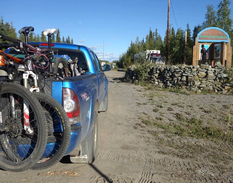
Getting there
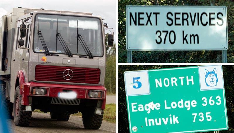
In 1958 they started to build the Dempster Highway; a 735km road from Dawson City in North-central Yukon to Inuvik in the North West Territories to facilitate oil and gas exploration. The Dempster Highway was going to be the link to the North. The promise of oil at Eagle Plains started it all, but construction stalled due to lack of insight, collaboration and lack of oil at Eagle Plains.
Then in 1968 the Americans found oil in Prudhoe Bay. To ensure Canadian sovereignty in the Arctic the Canadians pursued construction of the Dempster once again. The two lane gravel highway officially opened in 1979, the first Canadian highway to cross the Arctic Circle. It is built out of 1.2 to 2.4 meters thick of gravel overtop the permafrost to prevent the highway from sinking into the ground. Named after William John Duncan Dempster, a dogsled patroller who traveled the route between Dawson and Fort McPherson, the Dempster was laid out on a route previously used for centuries by the Gwitchin Indians as their route between the Yukon and Peel river systems.
________________________________________________________________________________________________
Signs warn you that you're way out there. Germans who bring their crazy lifted 4x4s over from the EU to Canada take their gravel road excursions very seriously!
We used our Toyota Tacoma on this trip; a reliable vehicle that offered flexibility to explore the microwave tower and gravel quarry roads along the Dempster. These areas can also be used as campsites. If you drive the Dempster it's a good idea to keep your gas tank at least half full since gas stations are few and far between. We carried an extra tire, but fortunately didn't need one. If you drive cautiously you shouldn't have a problem on this road. It's a gravel road that can get tricky in the wet but those used to driving logging/mining roads won't find this to be an issue. This handy Yukon Tourism handout served us a guide (Dempster Highway Travelogue). as did Walter Lanz's "Along the Dempster" guidebook, which we used as definitive.
Note – the gas station that used to be at the intersection of the Klondike Hwy and the start of the Dempster no longer exists. You have to get gas in Dawson City 40km down the Klondike Hwy, adding an extra 80km to your trip. Or you can take your chances ….
________________________________________________________________________________________________
Tombstones Yukon biking - Goldensides and Surfbird Mountain
________________________________________________________________________________________________
The Tombstones
After getting to the Tombstones campground we realized quickly that this was the busy time of the year as almost every campsite was full. It dipped below freezing that night and the last few day's snow glinted on mountain tops; surreal sight in the sunset at 11pm (this is the land of the midnight sun).
We started off with an out and back on the North Klondike Trail covering just a bit over 2km each way through short scrub that was just thick enough to hide views of any grizzlies. Not liking our chances of a wildlife encounter we then rode the Goldensides trail. The trailhead is located at 74.7km just past the Tombstone Lookout (all km marks follow the Lanz and Government guide convention of starting km 0 at the start of the Dempster). This is a short trail you can hike or ride and is only is 4km long with a 200m elevation gain to incredible views.
Optional routes traversing Goldensides can be attempted as a hike and are detailed on links at the end of this article but would involve a lot of hike-a-bike followed by ridgeline tussock rides.
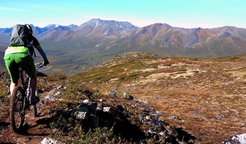
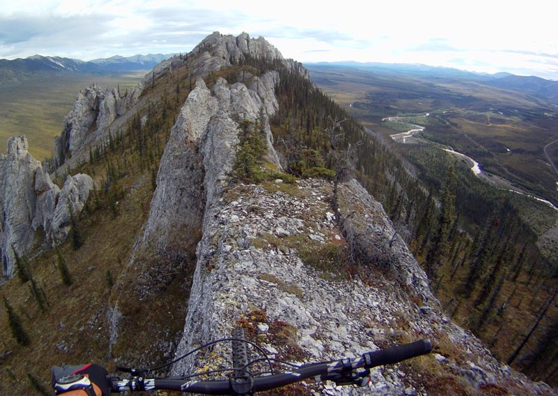
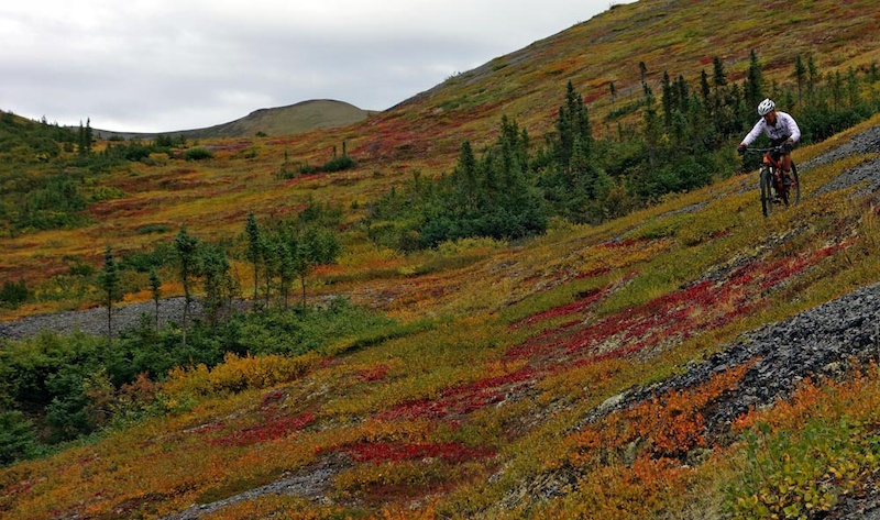
We also attempted to ride Surfbird at 98km. I had picked it as the best of all possible riding options since a microwave tower service road gets you a bit higher. In theory it should've worked out as the trailhead is in the alpine (alpine here starts at about 800m elevation) and the terrain is a gradual rise. Reality though is that it's a series of mellow permafrost-tussocked ridges. Instead of attaining ridgeline and getting a magnificent view of the backside of the Tombstones we slogged at little more than a snails pace. Fortunately temps were cool, bugs were absent and skies were blue making it a fine day to take your bike for a walk.
Days are fortunately long so we killed the rest of the daylight driving through the Blackstone Uplands (72-158km) through Windy Pass at 152.8km, and admiring Distincta Ridge and Peak as possible rides. We then continued into the Ogilvie Range and camped at Engineer Creek at 193.8km.
________________________________________________________________________________________________
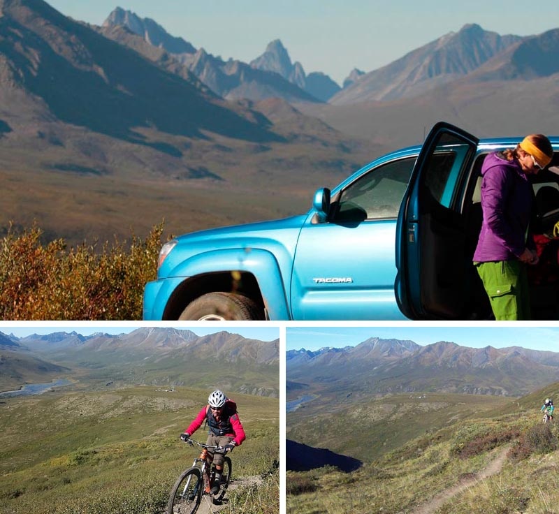
Day 2 of our trip. A short but sweet ride on the Goldensides trail just North of the Tombstones campground on the Dempster Highway
In the foreground Sharon 26'ering on a Pivot Mach 5.7 Carbon; in the backdrop the Tombstone Range and Klondike drainage
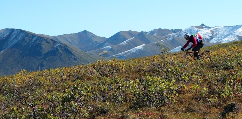
Surfbird Mountain looks like a good ride but we found that alpine tundra tussocks made for pretty much impossible riding conditions
Tussocks are raised hummock on the ground caused by frost heaves from the melt-freeze cycle of the permafrost just a short bit below the ground of the tundra. Riding on tussocks is basically a series of linked endos. Tussocks are the problem. Huge tussocks. Picture wet ground from the top layer of permafrost getting soggy after summer melt then ten thousand horses going through (the ground frost-heaves and forms these mounds). It's like having an endo hole every metre
Sapper Hill in the Ogilvies
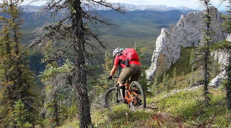
Engineer Creek's campground was practically deserted; it seems that most of the tourists stay in the Tombstones area. We had a great clear night at Engineer Creek practically to ourselves with Northern lights to give us a show. Our destination the next day was Sapper Hill; the trailhead is within minutes of the campground. The lower part of Sapper Hill is covered in white spruce and tussocks, becoming rockier in the spires near the top; very reminiscent of Dolomites limestones spires.
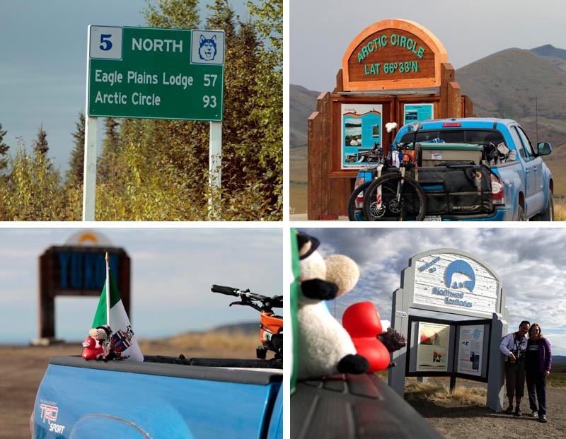
Sapper Hill makes for a fantastic hike and a challenging bike ride as the terrain is steep and the corners are sharp requiring Euro hop turns. You'll get stunning views towards the Ogilvie River and mountains. After our ride we packed up camp continued our drive North up 7 Mile Hill to another viewpoint of the Ogilvies. From here we are on the Eagle Plains plateau, stopping at Eagle Plains (369km) to get gas for $1.70/litre, then continuing on to the Arctic Circle (405.5km) where I fulfilled my dream of riding around the marker thus riding around the Arctic Circle (haha). We then continued on to our next campsite at the Rock River Campground (km 445.8 ).
________________________________________________________________________________________________
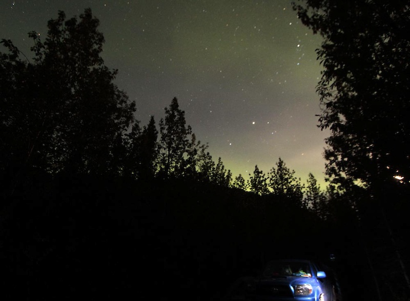
On Day 3 of our trip we camped at Engineer Creek at the foot of Sapper Hill. The skies come alive with the lights of the aurora

Snuck in a bike shot
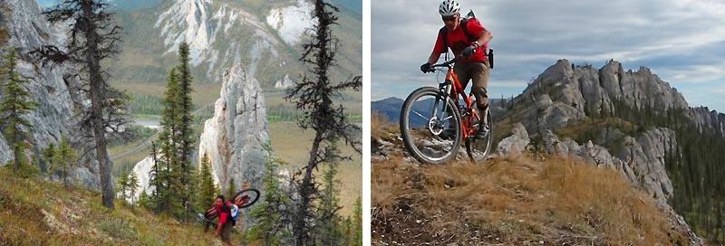
Sapper Hill is a hike-a-bike climb and an old-school technical descent. Those who can nose-wheelie and hop turn will love this trail.
Sapper Hill's exposure isn't for everyone but who wouldn't love to cartwheel down Dolomite spires
29'ering the Yukon
________________________________________________________________________________________________
The Arctic Circle and the North West Territories
The area surrounding the Dempster is very susceptible to wind. Since most of the arctic tundra around Eagle Plains is at a whopping 600m or greater above sea level and therefore above treeline, the campgrounds are located in river valleys. Rock River is no exception. It's another very deserted but well appointed campground with lots of facilities, wood and no people.
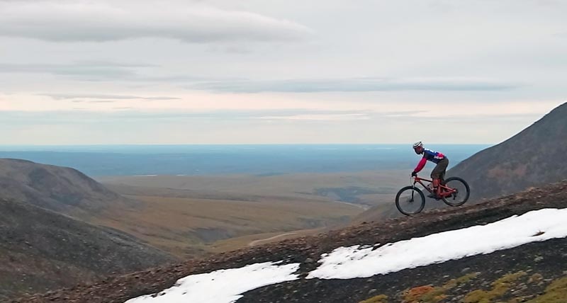
We get up to overcast skies and warm weather. Being in no rush today as the days are long, I play around in the Rock River making dams and generally farting around looking at different coloured rocks and wandering around admiring tundra. We drive to the border of NWT and the Yukon to look at another possible riding objective; the Continental Divide range. Unfortunately the rocks there are of the black, large-sized variety. After trying to ride some rain-soaked tundra tussocks we give this up as a bad idea and go for a hike; enjoying fine views from the Divide.
We then drive 25km into the North West Territories to the edge of the Peel River Gorge. Past this point you descend 853m in 51km to the Mackenzie Lowlands which is flat and not really that interesting to drive unless you want to go to Inuvik. At this point I wanted to get at least one ride in the NWT so we drove up another microwave tower road to a ridgeline where I managed to get a ride off a small knob near the Peel River Gorge frankly just to say I'd done it. Finally to end a lazy day, we checked out Mt Hare (412km) just south of the Rock River campground which I had scouted as another possible riding destination but which we were planning to ride the next day.
________________________________________________________________________________________________
It's been a long time dream of mine to ride at the Arctic Circle.
On day 4 of our trip we drove partway into the North West Territories to look at terrain around the Peel River Gorge and peer into the rather flat McKenzie basin. This little ridgeline is off a microwave tower and was a pleasant diversion but not a long ride by any means
On day 4 of our trip we had some time at the end of the day so we went over to the Mt Hare trailhead to check out the next day's ride. This is the first ridgeline of three. The trail starts pretty much in the alpine tundra at 700m or so then continues on for another 7kms or so to Mt Hare - looks like great opportunities for alpine ridgeline riding with exceptional views
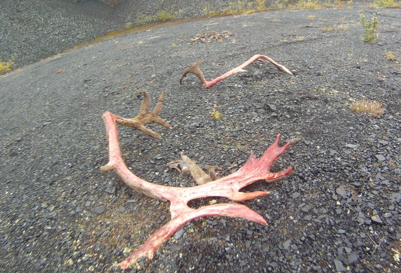
While exploring some gravel pullouts we came across some recent hunting kills. Apparently hunters strip the felt off the moose horns (the felt is considered an aphrodisiac by the native hunters). Thinking that the fresh kill might attract bears we booked it out of there.
At the Yukon/NWT border
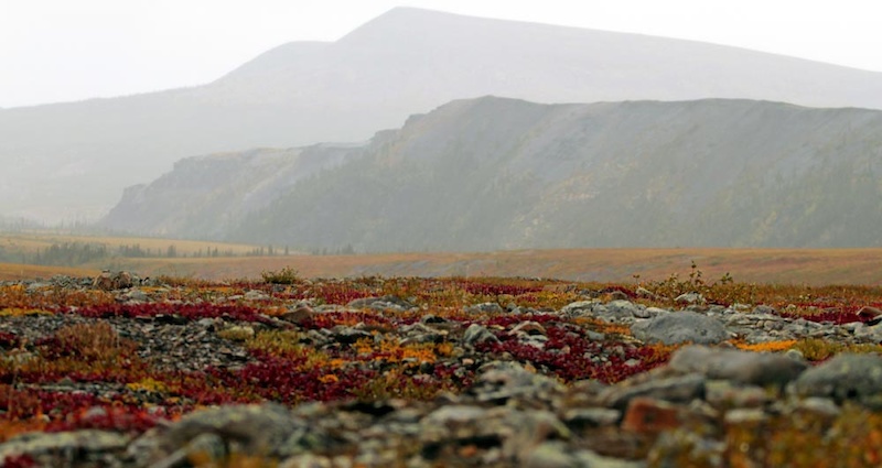
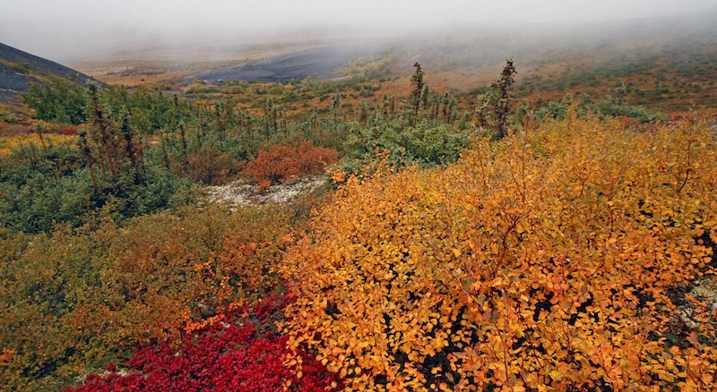
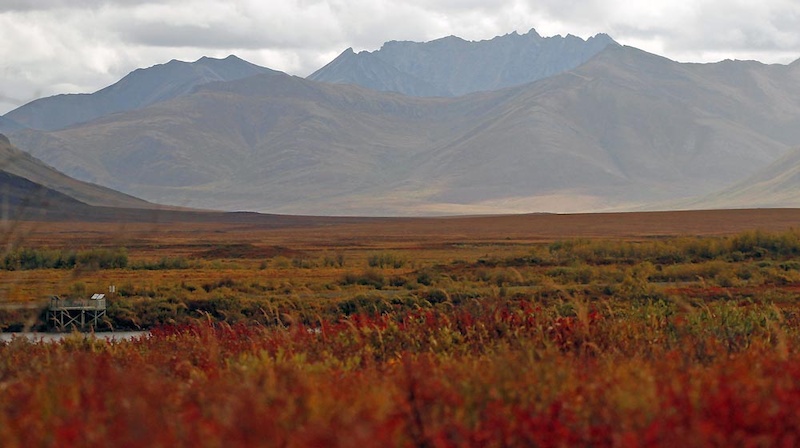
Fall colours come to the Arctic
On Friday the rain continued. It's an accident of weather that the high arctic tundra is actually quite dry; almost a desert in the winter months. Almost all the rain falls in July, August and September, unfortunately when the fall colour height of tourist season is on. We lay in the tent hoping it would stop, but alas no. Guess we won’t try to ride Mt Hare today and leave it for another reason to come back.
We pack up and drive back to Dawson taking the opportunity to marvel at the change in colours. When we drove north, the tundra was green, with some shades of red, and yellow. Fall colours on the Dempster were turned up a notch on our way south with an otherworldly display of vibrant saturated shades that have to be seen to be believed! What a change a few days made. The only downside is that now we're ruined for fall colours.
The clouds came in on day 5 of our trip so instead of biking up Mt Hare and chancing running into wildlife (ie Mr Grizz) with limited visibility to keep our distance we just did a short hike
Mt Hare colours
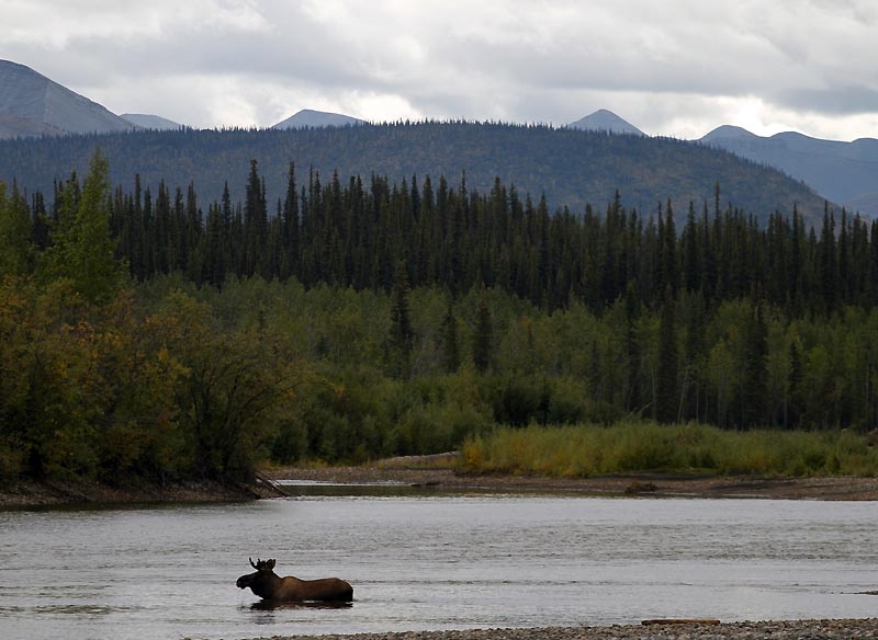
Moose on the Ogilvie River.
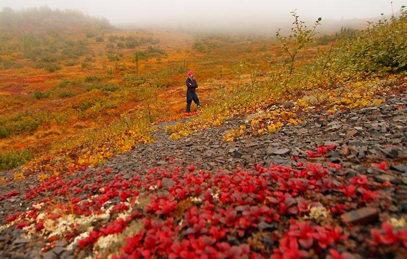
Typical Dempster Northern Yukon fall colours. The fall reds, oranges, yellows went from faint to startling in the week we spent on the Dempster Highway. This was taken on our way back heading south from the Arctic Circle to Dawson City at Tombstone Lookout
General advice
By now any biker will guess that finding epic long singletrack rides in alpine tundra is, at best, a haphazard exercise. I could have snowed you and try to show some snippets of nice trail and left out the descriptions of mining road, tundra or bogs but then this would be like many other articles trying to sell the sizzle but without a dose of reality. There's really one road here, with no support, no safety net and limited ability to bail easily if things go poorly. If you want certainty and more comfort the Whistler bike park is pretty awesome (no sarcasm). So plan accordingly; exploring the Yukon tundra by bike will be an adventure
Speaking of planning, as an aid to anyone else who wants to try exploration in this area, there are resources aplenty on hiking websites. I looked at a lot of maps, Google Earth, air photos, geological survey data and used the Lanz book extensively to try to prune a vast area down to a manageable slice of pie to explore. When I looked at approaches I looked for smooth terrain. Black rocks were generally too big to hike-a-bike. White/light grey rocks were fine. If there were tussocks or boggy tundra calculate travel time at 1km/h or less. Remember that a startled moose is a dangerous moose. There is a lot of blank space on the maps so keep the vagaries of mapping in such challenging terrain in mind especially when there are so few people around to correct maps. Frankly one could spend a lot more time exploring; particularly the high plains around the Arctic Circle and wander ridgelines for a long time without crossing another person's tracks.
If one is into that kind of thing it's also very easy to find first ascents and descents around here. But remember that a lot of the terrain in the high Arctic seems easy to navigate on map or air photos but the reality of the thickness of scrub, the undulating terrain and the everpresent tussocks means that there's a good chance that you'll be the first person to try a route, but also the last person.
The bottom line is that riding around or above the Arctic Circle in Northern Canada is an exercise in routefinding, in perseverance and in luck (timing for weather, absence of hostile wildlife etc). It's relatively safe if you stay close to the Dempster as that's your (limited) bailout but gets progressively more difficult as you leave beaten paths. It is possible to find astoundingly beautiful places to ride with insanely mindblowing scenery (also see Riley McIntosh's Yukon story from earlier in the year; coincidentally we had both planned trips at the same time) but be prepared to earn it. I wrote this article to open the door on a beautiful part of the world; hopefully others will step through the door and enjoy what the Northern Yukon's wildness has to offer
________________________________________________________________________________________________
Looking south towards Tombstone Visitors Centre
Chapman Lake
Useful links
-- Walter Lanz guidebook
-- Yukon Territory Driving the Dempster map and guide
-- Our personal website travelog (more beta and generalized hiking/biking shots useful as prep for future trips)
-- Tombstone hike from 2011
-- General info re Whitehorse and Carcross biking.

 Member since Oct 18, 2009
"Trip of a livetime" already planned for 2015. Catch my bike, get on a plane to Vancouver, buy a van, four month time...Vancouver, Whistler, Vancouver Island, Whitehorse, Yukon, Dempster...all the way up north...
Looking so much forward to that!!
Do try to do a day biking with Borealebiking.ca when you're in Whitehorse/Carcross. Disclosure is that they are good friends but also they are excellent hosts with great knowledge of trails and conditions.
Be sure about me, asking for further Information, when the trip coms close.
It was interesting that Environment YK, the Tombstones Centre and the locals advised us to make our own trails and keep off established trails because they said there were so few people up there that it was better to not bed in existing trails and that the lichen and plants could easily take the traffic of one person. Was surprising the plantlife was so resilient. Also found the diversity of geology and differences between Richardsons and Ogilvies remarkable.
Northern BC will be coming probably in a couple of weeks. Was at Nonda Ridge close to Muncho Lk/Toad River. Stone Mtn Provincial Park and Racing River for camping too. Tons of fishing around and lots of bison/bears
Looking forward to your BC article! I'm taking notes!
FYI the antlers are from Boreal Caribou, not moose I believe.
I know there is a trail from the radio tower above Dawson City to the Hwy. Did you mean King Solomon Dome? That is South East of town. That's where folks go for the Solstice party?
PS the Antlers are specifically Mountain Caribou. The Boreale Caribou live in the flat forests of Northern Alberta and the NWT. These are the caribou that are under pressure from the cut lines caused by the petro industry. The mountain caribou populations are still healthy. I have seen herds of 200 or more in the NWT mountains
Call me obnoxious but I think we can all agree that the majority of PB users do not think of this when they hear, "trip of a life time."
The Arctic Circle area is definitely more unknown and the riding there will be very highly technical, disjointed and more a choose-your-adventure style.
Second, I hate to have it out in the comment section but I'm sick of people being portrayed as the bad guy whenever they disagree with other users. (Especially when they've gone out of their way to voice their opinion in a respectful manner).
Finally, I would like to apologize if I offended you, leelau, my purpose was simply to point out a title that many people like myself may have found misleading, not to criticize your riding. ***Not trying to instigate, only correcting my miscommunication.
A respectful way to say what you said is "The riding wasn't as fast and flowy as I'd like."
The title was in no way misleading.