Trailforks App Summer Update
Summer is almost here and it's time for new things! This was initially a maintenance release but we couldn't help ourselves from adding a bunch of cool new features to help you with your biking adventures.
The app launched at the end of summer 2015, so this is the first summer with the app in the wild. We've had great feedback and usage with over 98,000 installs and increasing as the biking season ramps up. We have more cool app features planned for later this year.
Updates:
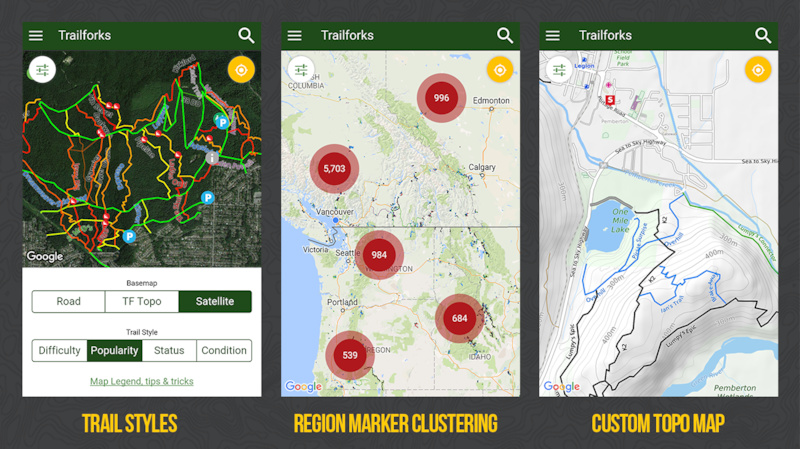
1. Region marker clustering
2. Change trail color style (difficulty, popularity, status, condition)
3. Custom TF topo basemap based on OSM data. Includes 20m contours
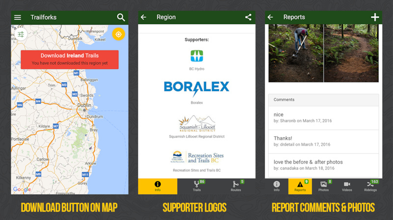
4. Map download button when viewing non downloaded region
5. Trail supporter logos
6. View report comments
7. Toggle to exclude gps location in submitting report
8. Trail association & karma removed from unsanctioned trails
9. Send debug info for troubleshooting issues
10. International emergency 911 numbers
11. Scale bar on map
12. Long press map to see lat/lng of point and click to get driving directions
13. When viewing ridelogs or routes, swipe left or right to scroll through routes on the map
14. New Zealand and Florida unique trail ratings
15, Better handling if gps/location is disabled on phone
16. Other bug fixes and tweaks
Stats:
App installs: 97,981
App screen views: 2,873,164
Android app rating average: 4.54 / 5 stars
Regions downloaded: 143,440
Top 10 downloaded regions: BC, UK, California, Washington, Utah, Alberta, New Zealand, Arizona, Australia, Colorado
Trail reports submitted from app: 3,605
Trail Ridden button clicked: 26,258
Route to trail: 13,819
Trail video views: 41,328
Trails clicked on map: 95,251
Call 911: 223 (I hope everyone is ok and ppl were just testing!)
Trail karma clicked: 953
Updates from release in October
1. Support for older Android devices (4.0 to 4.4)
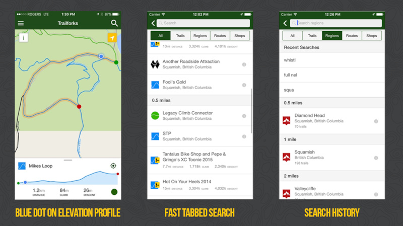
2. Improved app search. It should now be much faster and more pleasant to use. We've also added an "All" filter so you don't have to think about what you're searching for, you can just search.
3. Started drawing your current location on the elevation profile.
4. Can remove routes from the "My Routes" list (swipe left)
5. Saved ride plans now show an elevation profile in app.
6. Trail labels are now larger and easier to read on iOS.
Swipe left & right through ridelogs & routes
 |  |


Author Info:

Must Read This Week
Sign Up for the Pinkbike Newsletter - All the Biggest, Most Interesting Stories in your Inbox
PB Newsletter Signup
(sarcasm)
www.trailforks.com
Windows Phone is even more in a market share free fall than ever. Last quarter was one of the biggest drops in sales than ever before. Writing on the wall is that MS is going to pull the plug. I don't have a dog in this fight, and maybe WP is awesome for some, but it seems the market is not responding.
Source: Windows Phone sales plunged 70% in Q1 2016
mspoweruser.com/gartner-windows-phone-sales-plunged-70-q1-2016
I guess there isn't an API that's publicly available so the community could develop something? Not sure how we'd get around the lack of Google Maps SKD though... Either way, top work and it's always great to see devs respond to the users.
That being said I like to track how many km's I'm doing so I have to use strava too but its a pain using both apps and strava has been locking up my phones gps and other stupid things(I also do not like the way they exposed so many sensitive trails with the heatmap, you guys are way more respectful and subtle with your use of heatmaps and hiding sensitive trails etc) so my feature request to you guys is to build in offline map recording and overlays(able to overlay old rides on the fly while riding in an area) this way I could easily keep track of what trails I've ridden in an area. I'm sure strava wouldn't like it if you crept into their paid app features but I feel strava is stagnating and the paid app is super over priced(6$ a month). would rather pay you guys than strava if it came down to it, but I know you are trying to keep the app fully free and I respect that too. sorry for the wall of text but just some of my thoughts on trailforks
Good to hear you are considering the recording gps! You guys are the best I will bring you a case of beer if I ever am close to squamish
In google maps I have downloaded the maps for the maps for where I ride, and the user experience between online and offline is seamless.
Could I put in a feature request for the ability to have "private tracks" viewable in the app from GPX files saved to your device?