Trailforks Releases 3D Maps

Mar 8, 2023
by Jake  
photo

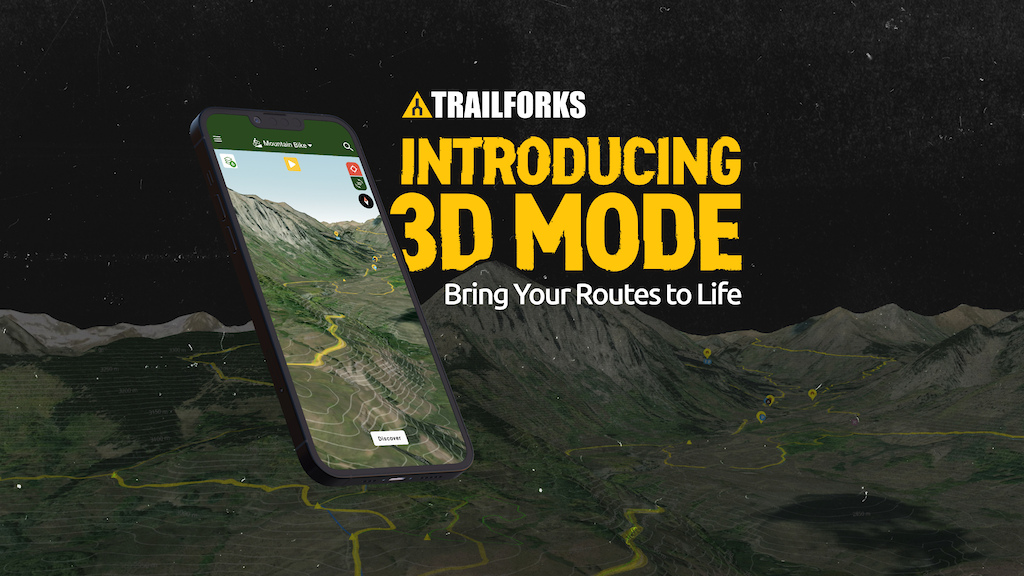
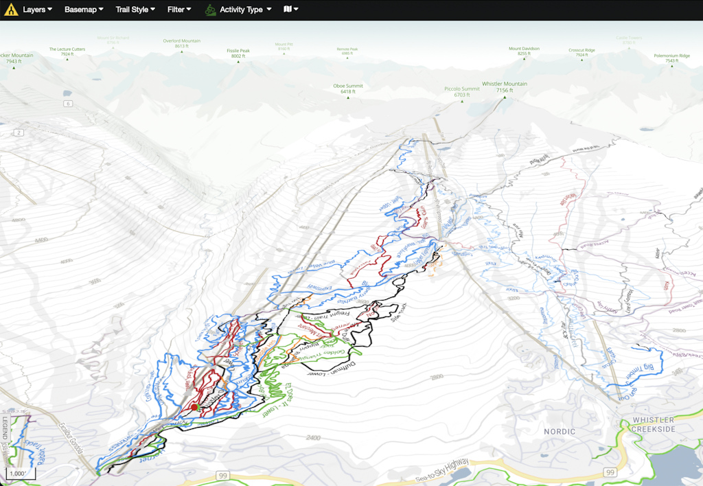
Visualize climbs, descents, and everything in between more easily than ever before. Trailforks’ trail maps are now available in 3D mode.

Whether you’re exploring new areas on your computer, or checking specific trails with the Trailforks app on your phone, you can see trails across the entire globe in three dimensions with the press of a button.

Introducing a Whole New Dimension

Three dimensions make maps more intuitive, like scouting the trail without actually riding the trail itself. Whether you want to spin up a mellow climb or mash the pedals up a wall, visualize the steepness of climbs and the sharpness of turns to better understand the challenges up ahead. Go 3D when piecing together longer routes or planning an extended adventure to get a deeper sense of what’s in store.

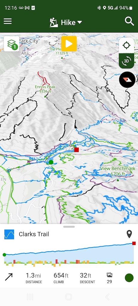
Conversely, find downhills that match your skills and adrenaline needs on a given day. When routes aren’t one way, examine them in 3D to get a sense of which direction looks more fun and flowy to you. Plus tour trails in 360 degrees to see what happens when you drop off the other side of the mountain, and tilt the map at any angle to see where the trail turns in the valleys.

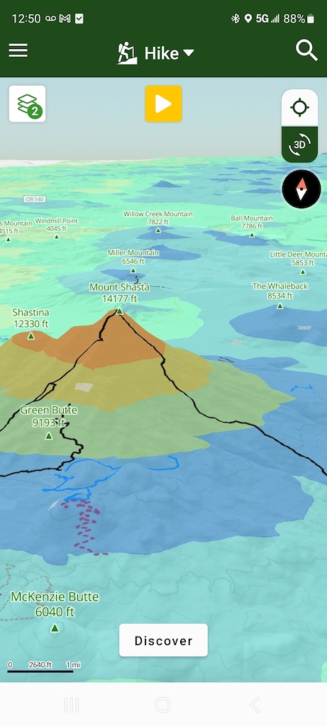
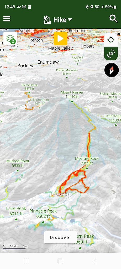
Enjoy the same level of map customization you’re accustomed to, just with an added dimension. Go 3D with any basemap, from the classic Trailforks Topo to Satellite imagery. Add and subtract any layer, from the Heatmap to the Precipitation Forecast. And change the trail style to color-code trails by everything from difficulty to when the trail was last ridden.

How to Activate 3D Mode

3D map from Trailforks
3D map in Trailforks

3D mode is available on trailforks.com and in the app.

3D on Trailforks.com
On the desktop website, click the “3D” button in the bottom right corner of the map. Get a 360-degree view and tilt the map up and down by holding the control button while moving the mouse.

3D in the Trailforks App
In the app, turn on 3D by tapping “3D” in the top right corner of the map, just under the locator button. Use two fingers to get a 360 view, and slide two thumbs up and down to tilt the map.

3D is Available to Everyone

3D map of Whistler on Trailforks

3D mode is available to everyone with a Trailforks account. Create a Trailforks account for free on Trailforks, and download the app in the App Store (iOS) and Google Play (Android).


To unlock trails across the globe, upgrade to Trailforks Pro with Outside+. Trailforks Pro with Outside+ also gives you global popularity heat maps so you can find popular trails—or avoid them. Plus find dry trails by checking trail condition reports, and see where others have ridden most recently.


Disclosure: Trailforks and Pinkbike are owned by Outside Interactive.

Author Info:
jake28 avatar

Member since Apr 20, 2010
15 articles
Report
Must Read This Week
Sign Up for the Pinkbike Newsletter - All the Biggest, Most Interesting Stories in your Inbox
PB Newsletter Signup

78 Comments
  • 191 0
 Looks cool. For someone living in The Netherlands, I hope they offer a fine resolution. Like cm accurate.
  • 13 101
flag amack5 (Mar 8, 2023 at 8:39) (Below Threshold)
 BAHAHHAHAHAHHAH this is funny, I don't think people are smart enough to get it though.
  • 38 4
 @amack5: they did get the fact that you are stupid
  • 17 0
 Maybe you can add a “Netheresting” route — 8848m / 29,029ft of riding distance with zero vertical gain.
  • 2 0
 Yeah, I have no need to see my local loop in 3D LOL
  • 2 1
 just gotta scale up the x axis til Amsterdam looks like Nepal
  • 3 0
 @WRCDH: I've had rides where the only indicated elevation gain was from changing weather conditions (low/high pressure) Smile
  • 38 0
 This is awesome. A quick request: it'd be sweet if (on the desktop version) pressing "N" re-oriented the map to north, and "U" re-oriented the view to a top-down view. Those are super handy shortcuts in Google Earth that would also be great in TF.
  • 1 1
 @ad15: manosphere idiot detected
  • 35 0
 Saskatchewan fans rejoice!!!!
  • 1 3
 LOL! I get it.
  • 19 0
 Sweet. Love the app. But the route creator needs some work to make it more user friendly and less buggy.
  • 5 0
 Route creator make me feel stupid and i do mapping on openstreetmap...
  • 14 0
 sweet now I can see how far behind the KOM I am in 3D
  • 2 0
 lollll insult to injury
  • 10 0
 Even better...Trailforks design a "link my trails to ride" tabe. So I can pull up a ride center and click on all the trails I want to ride...in the order I want to ride them. throw the phone in my pocket and have three different beeps to alert me to go left right or stay straight on the trail that I'm on. so I never have to pull out my phone again in every intersection to double check the map.
  • 2 0
 There is a create route function already and having it navigate with phone beeps would be awesome.
  • 8 1
 One thing I would like to see is emergency routes to make an exit from the trails possible. Not a side line to a drop or something, but a place to give EMS a meeting place for a downed rider. I had an experience last fall that, luckily, I could describe where EMS needs to be to access a hiker who had fainted on trail, but I am intimately familiar with the trail while others are not. Having users be able to mark roads, parking lots, or specific fire roads for first responders to enter the trails quickly and effectively would be nice. I think this would be a welcomed feature and I know I would happily help out on my local trails to make sure people are safe.
  • 6 6
 Maybe some kind of integration with the What3Words app
  • 1 0
 @Brad1000: This makes SO much sense. Pinpoint accuracy finding someone... And would help avoid rescuers requiring help from a local familiar with the network in finding the trail / injured rider.
  • 2 0
 Maybe learn to read a map or give your position using GPS?
  • 2 0
 @Brad1000: what3words is a pointless gimmick when everyone is already carrying a smartphone and can just send a dropped pin
  • 1 0
 @YukonMog: exactly! We already have Lat/Lon as a nearly global way of communicating position. No need at proprietary nonsense that requires all parties to maintain active subscriptions.
  • 1 0
 Curious how you’d propose these emergency routes get created, curates, and vetted
  • 3 0
 @Brad1000: What3Words is dumb, as @YukonMog said we have a universal lat/lng. why pay a company to use their proprietary API, its not free.

The Trailforks app emergency page makes it easy to view and share your current location verbally over the phone or sending it as a TXT message.

Creating emergency routes is nothing something that would be scalable. Many riding networks have EMS muster stations and many regions add these to the Trailforks map with the + symbol.
example: www.trailforks.com/region/nelson-5259/?activitytype=1&z=14.6&lat=-41.28617&lon=173.30909
  • 1 0
 @canadaka and @YukonMog Sorry to offend....I was simply posting a thought in response to @johndrop7 as my local 1st responders have advertised that they in fact use What3Words.
Tbh I rarely use Trailforks and did not realize that there was an emergency page. Thanks for pointing it out.
  • 9 0
 This will be a great product to use for several things. tup
  • 8 0
 Now I can ride with 3D goggles and not even have to worry about vegetation and obstacles.
  • 5 0
 I think a nice addition to this would be an integration of an Elevation Heatmap based on the angle of inclination over a given distance. Steep hills red, flatland green, etc. Had I been able to visually see this on some trips to Brown County or Bentonville I probably would have planned my route a bit wiser.
  • 6 0
 I like it. A lot. Except it murders batteries, especially in satellite views
  • 1 0
 Interesting, have you experienced this with other mapping apps such as Gaia (3D with satellite)?
  • 39 3
 murders batteries quicker than a 55 year old weekend warrior ebiker with a beer gut
  • 4 0
 @JDFF: Never tried other apps in 3D. It's so bad on TF mobile app though that I don't even bother at all (lost 30% in less than a minute). It's still great on desktop for planning rides. What I'd like to see them do is put the Mapbox Satellite w/ Contours on mobile app, don't think that would kill batteries any faster and would show slopes with actual layout.
  • 1 0
 @DizzyNinja: good information thank you.
  • 1 1
 Doesn't kill my battery. I've already browsed the upcoming bike park tour for over an hour and the battery is still over 70% and it has the whole day's consumption (approx. 10 h).
Maybe you have other problems with your phone?
  • 1 0
 @mcharza: It's rather specific to using TF in 3D
  • 2 0
 3D maps on from any app is going to use more battery.

We were smart about adding 3D to the Trailforks app, we only "turn on" 3D and load the 3d terrain tiles if the map is tilted, if its flat, then we added our own code to not load this data, saving network requests and likely battery use.
  • 5 0
 Probably goes without saying but you have to update the app to reveal the feature. Just a tip for those of us that are non-tech savvy
  • 6 0
 Guess if you're living in the prairies, the 3D map will look almost like 2D!
  • 1 0
 nah just zoom waaaaaaaaaaaay in!
  • 2 0
 I need 1 meter contour lines
  • 2 0
 @Jheitt142: You zoom right in you might see the grass and dirt! Big Grin
  • 6 0
 Throw in an option change the vertical exaggeration so you can get some more detail in areas with flatter terrain.
  • 5 0
 This will help so much. Finally a nice update
  • 6 1
 This feature is game changing. Great job!
  • 4 0
 I’m so excited for this feature to bring elevation changes to my local trails. Thank you, Outside.
  • 4 0
 Nice work TF team. This is an awesome development, super helpful for new trails
  • 3 2
 Hey pinkbike/trailfork, I love some of the new functionality and layers as I have started using this app for backcountry skiing too. But your avy layer could use some fixing and defining in the legend. You should also get someone to enter all the major backcountry runs/zones as it can help too; now that its a paid app, I expect this to be done by trailforks and not for free by some users.
  • 1 0
 Plenty of programs that provide this info but don't expect great beta on runs. Even OnX, probably the most complete of the apps from this perspective, is woefully lacking on runs because of the gatekeeping in backcountry skiing. People don't want to give up their pow stashes and really the only way to find them is by exploring, reading maps, or making friends with knowledgable folks.
  • 1 0
 Your best bet is importing this data (via API calls) into Google Earth or Gaia
  • 1 0
 @Jgallegos335: here in utah we have the wbskiing app that names all the main runs of the wasatch near slc. but the app is not nearly as well put together.
  • 1 0
 Looking forward to trying it out. Lots of negative comments on here. But, I can tell you first hand trailforks has changed my mountain bike life and I have been riding for 30 years. If you only ride the same general trails probalby not the app for you. But, if you explore and ride in areas you have never been, then this is a game changer. I have literally been all over the world and rode areas/trails I would have never dreamed of finding. In April I spent a month in Arizona riding and camping not knowing one single trial a head of time. And I rode 100's of miles all over the state using nothing more than trail forks in some pretty remote area. (I carry two phones (one without sim as TF works using just GPS) and some kind of topo map just in case. The app has it's issues, for sure. But the upside far, far out weighs these tiny glitches. Hey, thank you very much trailfork folks for making this service. I love you! LOL
  • 3 0
 Ah super cool - it's depressing that Ontario is so flat, 3D is barely noticeable here!
  • 4 11
flag vinay FL (Mar 8, 2023 at 8:47) (Below Threshold)
 Kind of depends on your world view. I'm in the camp that insists the earth is round. Like ball-round, not pancake-round. So just zoom out and you'll be fine. But indeed it really depends on the software. Marble for instance does understand/accept that the world is spherical. Google seems to think that the earth is flat and the continents keep repeating themselves the further you zoom out. "Oh wait, there is another Asia again, another Europe, America, hey there is another Asia..." Google is popular though, which worries me. I don't even dare to zoom out in Trailforks now...
  • 3 0
 Cool, now you can visualize Bender's JAW DROP...
  • 3 0
 Awesome.
  • 10 8
 2022 Advent Contest winners are still not supported though :-/
  • 2 0
 This is actually pretty great.
  • 1 0
 That’s good and all , but when are they bringing out the button that teleports me to the top of the downhill trails?
  • 2 0
 damn i put all my eggs in the komoot app
  • 2 0
 Awesome feature. Cheers TF
  • 4 2
 and still not free ! but built by riders for riders! just sayin!!!!!
  • 2 0
 I somewhat agree, especially now with the new added feature they should at least expand a free basic not so limited version or at least charge a one time fee, like- $20 for the basic map,covering a larger region; for people that rarely use the app but would like to plot trails, if their going on vacation somewhere new, once or twice a year. The continuation billing cycle is BS for the random users!
  • 1 0
 please...you are going to deny the guys making a living?
  • 2 0
 Thanks Trailforks! that's amazing
  • 2 0
 Is this where I find out my mountains aren't even mole hills?
  • 2 0
 Who cares? No interest in pay wall apps. Rei ftw
  • 1 0
 It would be really cool if we could get gpx files off horrible climbs to use with turbo trainers
  • 1 0
 @jake28: Awesome. Thank you
  • 1 0
 That Shasta route is looking good.
  • 2 1
 haaaa that's where the massive price hike went!
  • 4 1
 There has been no price change to Trailforks Pro. You may be confused with the other subscription we now offer, Outside+ which does cost more, but includes much more than Trailforks Pro.
  • 3 0
 The outdoor industry has been booming so much lately that even prices are taking a hike! …I’ll show myself out.
  • 1 0
 Well played. Now go to your room.
  • 1 0
 TraiDorks rejoice!


Copyright © 2000 - 2024. Pinkbike.com. All rights reserved.
dv65 0.047371
Mobile Version of Website