Trailforks Basemap for Garmin
I have been using the Garmin Edge device for a quite a while now. Once basemaps made their way into the Edge series back around 2009, I purchased the Edge 705. The maps back then were similar to what you might see in your car, and like all maps available at the time, they were designed mostly with automobiles in mind. Since then I have continued to upgrade my bike computer in hope that the maps would improve, not only to include mountain bike trails, but for the theme to be specific to bike riders as well.
![Trailforks Basemap for Garmin]()
Since the release of the Trailforks Mobile App, the need for my Edge series unit has waned. However, I often still find myself throwing it onto my stem and relying upon my latest version, the Edge 810. There are some areas that it shines and continues to provide the following benefits where my phone would sometimes fall short:
1) Battery life
2) Mounting convenience – Didn’t have to bust it out of my backpack
3) Durability – That unit flew off my bar when I hit a cattle crossing and it skipped on the pavement for about 10 meters. Only scratched the corners, and didn’t even scratch the screen.
4) Map – If I was riding somewhere new, in town, on paved roads, it helped a little, sometimes.
![Trailforks Basemap for Garmin]()
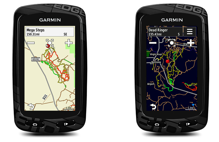
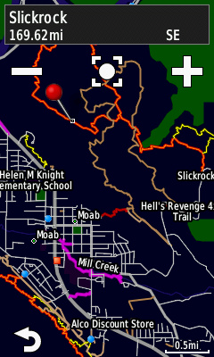
MOUNTAIN BIKE THEME
Once again we find ourselves trying to figure out how to de-emphasize roads, and emphasize all things bicycle related. As we did with our Traiforks Custom Basemaps, all paved roads are stripped of their flowery designations, and are reduced to a grayscale line. Dirt access roads are given a hint of dirty color, but the real colors are exactly where they should be, on the trails. And no more zooming down so low that you can only see the trail and nothing else. I like to see an entire trail system glowing bright revealing all the connections and ride options.
![Trailforks Basemap for Garmin]()
STANDARD DIFFICULTY COLORS
This is where we had to deviate from the “standard” green, blue, and black. Initially, my first version of the map used the IMBA Difficulty Rating System, but this proved difficult to read on a Garmin summer map. I am not sure of the history of how these colors and symbols came into being, but it has never made logical sense to me. And with the limited color variations on the Garmin, providing different shades of the same color simply did not work:
Green (Easy) – This color makes sense and is mostly acceptable to display on the map if you do not use strong shades of green as landcover for parks and forested areas.
Now here is where we run into problems:
Blue (Intermediate) – This makes less sense to me. Why would you choose the color of water to represent the most common trail color? In Trailforks we did our best to mitigate this issue by changing our basemap watercolor to be more of a gray-blue while changing our trails be a more distinct blue. This was not an option on the Garmin, anything blue simply looked more like a river than a trail. Imagine all those trails that travel up and down canyons and hollows. How many follow a river or stream? No version of blue was discernible at a glance and some intersections were even confusing after a long hard stare.
Black (Advanced) – A Black trail has multiple problems.
- Emphasis – To emphasize anything on a thematic map it is most easy for the eye to isolate it when it is the only item in a picture with color. We use this concept heavily in our basemap, and while a thick black line does stand out, it still exists within the grayscale spectrum. So when compared to trails with color, it does not catch your eye the same way.
- Contour Lines – While not available yet we tested our map using transparent backgrounds against a terrain map that employed contour lines. Contour lines on the Garmin are black lines, and with many trails following along with contours, this was also confusing in mountainous areas.
- Night – Our theme works well at night, but it would not have if we used black. Garmin does provide the ability to provide different colors for night, but we wanted consistency between night and day as much as possible.
Black-Black (Expert) – So this is a total mystery to me. Not only is black a less than ideal trail color choice, but the color is already taken. Now your map is required to have some kind of floating icon along the trail to differentiate.
The above standard works good for ski/piste maps, where water is frozen or covered, and the runs are big and wide enough to accommodate big double diamond icons.
TRAILFORKS GARMIN DIFFICULTY COLORS
My first efforts in tuning this map was to create local extractions, where I tested many trail combinations on the trails around my house. Part of the area is within the US Forest Service boundaries, so I could test how these colors looked on both a plain background and a green forest polygon. Some colors looked great while sitting at my computer, but out on the trail, I could not tell the difference in colors. I tried straight colors, tracks with borders, and even bitmaps with various patterns on many many rides.
![Trailforks Basemap for Garmin]()
But even after trying all these color combinations, and even though I was the one that created the color key, I could often not remember all these different patterns. I had to boil it down to the basic trail colors that stood out the most and provided the most contrast between each other. What I found was that a simple “Severity” system appeared to work the best and provide a simplistic understanding that was easy to remember. Basically, green is the easiest, and the colors become more severe as the trail gets more difficult:
![Trailforks Basemap for Garmin]()
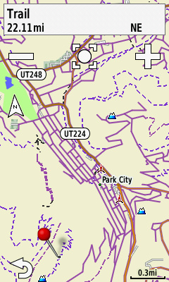
POIs
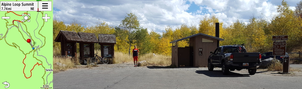
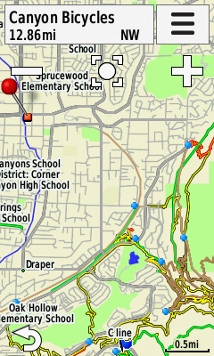
We wanted to display some important points from the Trailforks database on the map, but with a smaller screen, we did not want to clutter up the map with icons. So we decided to just include the points of interest that really matter. We considered the map as 3 zones: One the trail, at the trailhead, and in town. To keep clutter to a minimum, we only show one POI in each zone. So in town we display bike shops. Trailheads serve as navigation both to the trails and back to your vehicle. When riding out on the trails we display TTFs.
![Trailforks Basemap for Garmin]()
Parking/ Trailheads: The blue dot on the map serves as a great guide to get you to the trailhead when riding your bike from home or a hotel in town. Besides color, our chosen POI markers are shown at high and low zoom levels so that they stand out as you roll into town and are hot to get out on the dirt.
![Trailforks Basemap for Garmin]()
TTF: I like to see a TTF on the trail when I am in a massive trail complex that I know has some jumps, but I can’t remember exactly which track to take. This is common in the desert, where often many trails exist, but if you miss the jump line, you have to pedal back up. Also, a TTF can sometimes be just slightly off the main trail. For this reason, we made this icon an upside-down triangle that points its tip to the exact location. A fat icon has the tendency to obscure the TTF as you approach, not knowing which side of the trail to look for the option.
![Trailforks Basemap for Garmin]()
STRAVA
![Trailforks Basemap for Garmin]()
ROADIES
OK, I admit, I do not like riding a fatbike and I like to ride my cyclocross bike on local paved paths, gravel roads, and around town for training purposes. When I ride into the city I don’t remember which roads have a nice shoulder or bike lane, and which roads will probably kill you on site. So to help navigate around town and to trailheads, I added 2 additional colors.
![Trailforks Basemap for Garmin]()
Note: A couple things to keep in mind. First, these are not a collection of courses or jpg images, these are Garmin basemap IMG files. They have to be or else we could never cover such large areas and have the unit tell you which trail you are on. Also each geographic area is calculated based upon the trails in that region with a bit of margin. Some locations this area should maybe be bigger or are even too big. Please keep in mind that this is a first release, and we welcome input that we can incorporate into subsequent releases. Also to improve these maps we suggest contributing to the OpenStreetMap project by lining up roads and dirt roads (tracks). By doing this the Garmin map (and Trailforks Basemap) will be more accurate in showing trail to road connections. The trail & POI data is from the Trailforks database, we will updated the Garmin maps maybe twice a year.
DOWNLOAD TRAILFORKS GARMIN BASEMAPS
MENTIONS: @trailforks
Since the release of the Trailforks Mobile App, the need for my Edge series unit has waned. However, I often still find myself throwing it onto my stem and relying upon my latest version, the Edge 810. There are some areas that it shines and continues to provide the following benefits where my phone would sometimes fall short:
1) Battery life
2) Mounting convenience – Didn’t have to bust it out of my backpack
3) Durability – That unit flew off my bar when I hit a cattle crossing and it skipped on the pavement for about 10 meters. Only scratched the corners, and didn’t even scratch the screen.
4) Map – If I was riding somewhere new, in town, on paved roads, it helped a little, sometimes.
For all intents and purposes, the map provided little help out on the trails. I had just about given up on any hopes of a real bike-centric map, until I heard that the Garmin Edge 1000 was based upon OpenStreetMap. I thought that this would be the perfect opportunity for Garmin to revamp the theme from the old NT series Automobile Maps to a true bike-centric map. And while the update did improve with the advent of some actual trail data, the theme was still basically the same.
Here at Trailforks, we decided to take a crack at creating our own Garmin Basemap theme. Now keep in mind that these devices are low resolution with a reduced color palette as compared to a modern smartphone. This is mostly to accommodate rendering of large maps on a small device, all while maintaining the battery life. And dare I say, keeping costs low. Well, ahem, moving on and without further ado, we present the Trailforks Garmin Basemap.
Here at Trailforks, we decided to take a crack at creating our own Garmin Basemap theme. Now keep in mind that these devices are low resolution with a reduced color palette as compared to a modern smartphone. This is mostly to accommodate rendering of large maps on a small device, all while maintaining the battery life. And dare I say, keeping costs low. Well, ahem, moving on and without further ado, we present the Trailforks Garmin Basemap.
MOUNTAIN BIKE THEME
Once again we find ourselves trying to figure out how to de-emphasize roads, and emphasize all things bicycle related. As we did with our Traiforks Custom Basemaps, all paved roads are stripped of their flowery designations, and are reduced to a grayscale line. Dirt access roads are given a hint of dirty color, but the real colors are exactly where they should be, on the trails. And no more zooming down so low that you can only see the trail and nothing else. I like to see an entire trail system glowing bright revealing all the connections and ride options.
This being an initial (beta?) release, we started simple and are only including POI's that we feel make a real difference. We have always liked to keep our maps very clean by not enabling every POI, route, and layer, but provide maximum utility by allowing the user to pick and choose what they want to see. Such an approach is more difficult with a single base map, so we started by only including the bare minimum: Trails, Parking, TTF, and Bike Shops. Of course, the most important feature is the trails, but there needs to be some clarification on how we display them.
STANDARD DIFFICULTY COLORS
This is where we had to deviate from the “standard” green, blue, and black. Initially, my first version of the map used the IMBA Difficulty Rating System, but this proved difficult to read on a Garmin summer map. I am not sure of the history of how these colors and symbols came into being, but it has never made logical sense to me. And with the limited color variations on the Garmin, providing different shades of the same color simply did not work:
Green (Easy) – This color makes sense and is mostly acceptable to display on the map if you do not use strong shades of green as landcover for parks and forested areas.
Now here is where we run into problems:
Blue (Intermediate) – This makes less sense to me. Why would you choose the color of water to represent the most common trail color? In Trailforks we did our best to mitigate this issue by changing our basemap watercolor to be more of a gray-blue while changing our trails be a more distinct blue. This was not an option on the Garmin, anything blue simply looked more like a river than a trail. Imagine all those trails that travel up and down canyons and hollows. How many follow a river or stream? No version of blue was discernible at a glance and some intersections were even confusing after a long hard stare.
Black (Advanced) – A Black trail has multiple problems.
- Emphasis – To emphasize anything on a thematic map it is most easy for the eye to isolate it when it is the only item in a picture with color. We use this concept heavily in our basemap, and while a thick black line does stand out, it still exists within the grayscale spectrum. So when compared to trails with color, it does not catch your eye the same way.
- Contour Lines – While not available yet we tested our map using transparent backgrounds against a terrain map that employed contour lines. Contour lines on the Garmin are black lines, and with many trails following along with contours, this was also confusing in mountainous areas.
- Night – Our theme works well at night, but it would not have if we used black. Garmin does provide the ability to provide different colors for night, but we wanted consistency between night and day as much as possible.
Black-Black (Expert) – So this is a total mystery to me. Not only is black a less than ideal trail color choice, but the color is already taken. Now your map is required to have some kind of floating icon along the trail to differentiate.
The above standard works good for ski/piste maps, where water is frozen or covered, and the runs are big and wide enough to accommodate big double diamond icons.
TRAILFORKS GARMIN DIFFICULTY COLORS
My first efforts in tuning this map was to create local extractions, where I tested many trail combinations on the trails around my house. Part of the area is within the US Forest Service boundaries, so I could test how these colors looked on both a plain background and a green forest polygon. Some colors looked great while sitting at my computer, but out on the trail, I could not tell the difference in colors. I tried straight colors, tracks with borders, and even bitmaps with various patterns on many many rides.
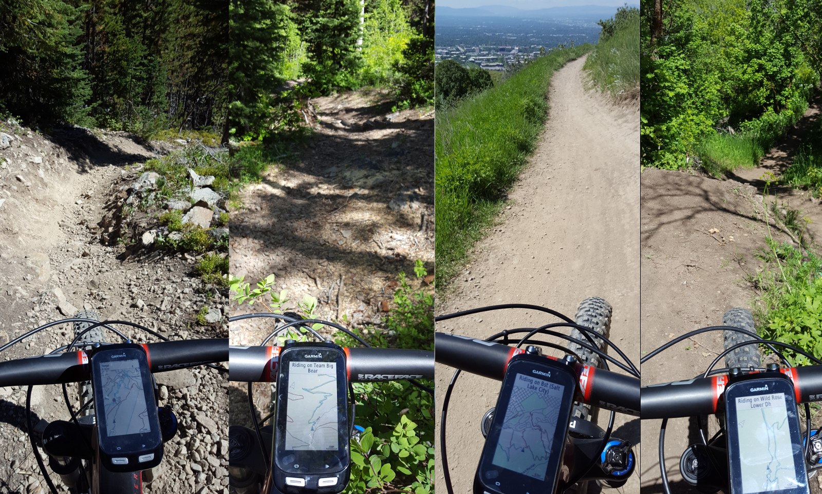
But even after trying all these color combinations, and even though I was the one that created the color key, I could often not remember all these different patterns. I had to boil it down to the basic trail colors that stood out the most and provided the most contrast between each other. What I found was that a simple “Severity” system appeared to work the best and provide a simplistic understanding that was easy to remember. Basically, green is the easiest, and the colors become more severe as the trail gets more difficult:
Green (Easy) – Same as the standard, but I had to make it brighter and with a dark outline on the edges to be sure that I could view it easily in daylight while riding on green shaded park polygons.
Yellow (Intermediate) – In a severity system, this is like a minor alarm (not blue), still probably easy, but watch out for some difficult sections, narrow trail, maybe even some exposure.
Orange (Advanced) – This is like a major alarm in a severity system, and provides a nice bright color (not black).
Red (Expert) – This is the same as what we use on Trailforks to denote an Expert trail, because in a tight trail system it is difficult enough to pack in trail labels, much less a floating double diamond icon. Even the red here had to be a bit of a darker red (like maroon), because on the Garmin it was difficult to differentiate between orange and red out on the trail in the mid-day sun.
POIs
We wanted to display some important points from the Trailforks database on the map, but with a smaller screen, we did not want to clutter up the map with icons. So we decided to just include the points of interest that really matter. We considered the map as 3 zones: One the trail, at the trailhead, and in town. To keep clutter to a minimum, we only show one POI in each zone. So in town we display bike shops. Trailheads serve as navigation both to the trails and back to your vehicle. When riding out on the trails we display TTFs.
Parking/ Trailheads: The blue dot on the map serves as a great guide to get you to the trailhead when riding your bike from home or a hotel in town. Besides color, our chosen POI markers are shown at high and low zoom levels so that they stand out as you roll into town and are hot to get out on the dirt.
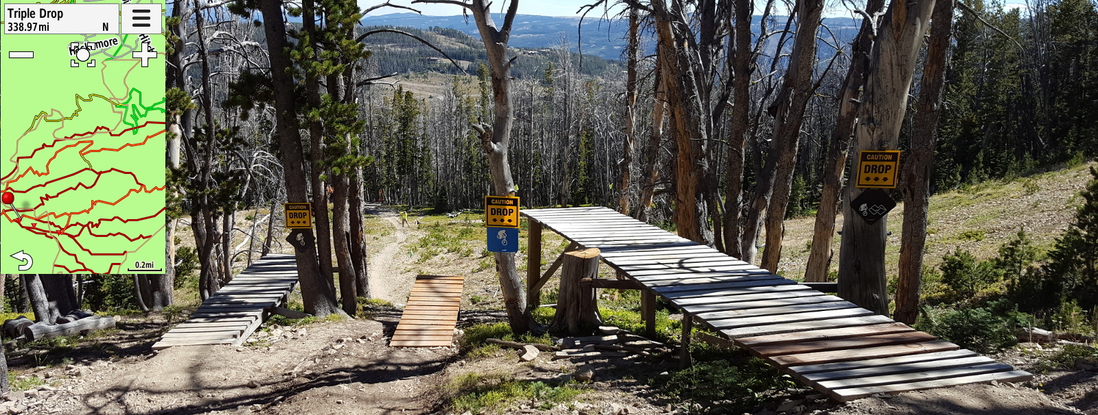
TTF: I like to see a TTF on the trail when I am in a massive trail complex that I know has some jumps, but I can’t remember exactly which track to take. This is common in the desert, where often many trails exist, but if you miss the jump line, you have to pedal back up. Also, a TTF can sometimes be just slightly off the main trail. For this reason, we made this icon an upside-down triangle that points its tip to the exact location. A fat icon has the tendency to obscure the TTF as you approach, not knowing which side of the trail to look for the option.
Bike Shops
Not something I would typically want obscuring a trail, but since these icons remain mostly in town, they don’t clutter up the trail, but come in very handy when tools and an expert hand is required. We placed the bike shop icon at high and low zoom levels so that when you are arriving in a new town, you can easily see where all of them are in relation to you and the local trails. I am sure it never happens to you, but I always seem to forget something I need, and I remember it en route.
Not something I would typically want obscuring a trail, but since these icons remain mostly in town, they don’t clutter up the trail, but come in very handy when tools and an expert hand is required. We placed the bike shop icon at high and low zoom levels so that when you are arriving in a new town, you can easily see where all of them are in relation to you and the local trails. I am sure it never happens to you, but I always seem to forget something I need, and I remember it en route.
STRAVA
Now this was kind of an added bonus. Up until I started testing our new Garmin theme, I could see strava segments that I had starred, except that they were floating around in outer space. I kind of knew where they were, but it wasn't always clear how or exactly when I would get to the start of one because I could not see the trail leading up to the beginning. I had been testing this all through the summer of 2016, but it was only part way through that I started to use the Garmin/Strava feature. One ride after doing a firmware update on my unit, and I noticed some of my favorite Strava DH flowy segments appear right in the context of the trail.
ROADIES
OK, I admit, I do not like riding a fatbike and I like to ride my cyclocross bike on local paved paths, gravel roads, and around town for training purposes. When I ride into the city I don’t remember which roads have a nice shoulder or bike lane, and which roads will probably kill you on site. So to help navigate around town and to trailheads, I added 2 additional colors.
Purple (Paved Paths)
They are thick and bright, and appear to be a highway in comparison to the actual automobile highways, but isn’t that what they are? A highway for bikes should be the most prominent track on a road map for bikes.
Cyan (Bike Lanes)
I love having this layer when I am riding around the city or connecting between two trail systems. It tells me exactly which are the best roads to ride a bike safely on, similar to our Trailforks basemap bike lane theme.
Note: A couple things to keep in mind. First, these are not a collection of courses or jpg images, these are Garmin basemap IMG files. They have to be or else we could never cover such large areas and have the unit tell you which trail you are on. Also each geographic area is calculated based upon the trails in that region with a bit of margin. Some locations this area should maybe be bigger or are even too big. Please keep in mind that this is a first release, and we welcome input that we can incorporate into subsequent releases. Also to improve these maps we suggest contributing to the OpenStreetMap project by lining up roads and dirt roads (tracks). By doing this the Garmin map (and Trailforks Basemap) will be more accurate in showing trail to road connections. The trail & POI data is from the Trailforks database, we will updated the Garmin maps maybe twice a year.
DOWNLOAD TRAILFORKS GARMIN BASEMAPS
MENTIONS: @trailforks
Author Info:

Must Read This Week
Sign Up for the Pinkbike Newsletter - All the Biggest, Most Interesting Stories in your Inbox
PB Newsletter Signup
Question for you: did you have trail karma before downloading? I have existing karma points, but they don't seem to be applicable to the Garmin download. So, I was wondering if you donated today specifically to get the Garmin download, and if so, if you got the points immediately?
If your browser is displaying garbage (binary), your browser may interpret the extension "*.img" as an actual image and try to display it. Try right clicking on the link for British Columbia and doing a "Save As". Save it to your local disk then copy it to your Garmin unit.
If you still have trouble, send me a message on PB. In future release, we may just zip them up so that browsers don't get confused by the IMG extension.
Existing Karma points should work, but we encourage you to donate a new
Here is what my SD card looks like: i.imgur.com/novLs18.png
You also need to select the map on the device.
Menu -> Tools (bottom right wrench) -> System -> Map -> Select Map
As for changes around the world - you have typically some local rating adjustments in all the difficulty rating in other sports too: from what I do, climbing and white water have it as well as biking has it. It should not deviate dramatically, but some regions tend ot underrate difficulty, for instance.
With that said I've though I could create a feature that scanned OSM for gps tracks closely matching a hidden/sensitive trail on Trailforks and then notify a regional admin of this. So they can go on OSM and edit or delete it. So Trailforks could be used as a tool to monitor OSM content.
As for the GPS tracks: so you store even sub-second precision from the GPX/NMEA files? The problem is not that the OSM GPS traces storage simplifies anything, but it just cuts off the decimal time values (i.e., tenths of second) and thus the result relies on correct ordering of points only. This decision was obviously done in the time when the 10Hz GPS devices were as common as yeti...
I personally don't see the point. At least in my area Openstreet maps are much more comprehensive and you can already download the maps to your Garmin for free (openstreetmap.nl)
Is the point of Trailforks to provide a new smart phone app for mountain bike specific trails without paying for Openstreet map license?
The idea is to simply provide a way for Trailforks users to view the trails in Trailforks on their map capable Garmin Units. The theme is meant to be very simplistic and easy to remember so that you can view it at a glance, and we didn't want to include everything in the OSM database, only things that help a bike rider navigate to a trail, while on the trail.
However, the major issue I have found with the maps have been trails that we drawn by others near each other but not properly connected. But it sounds like the filter trail forks is using is purposely leaving off connecting trails to keep the maps uncluttered and feature the best mountain bike trails? Is that correct? If so, i can see the benefit but wouldn't that prevent proper navigation?
To one of your other points, some of the free maps I've downloaded have started to get a bit cluttered due to different surface tags or difficulty level tagging as well as points of interest. In some areas marked as forest, the trails can be difficult to read on my Garmin, so I started using OpenMTBmaps. Like what you are doing with Trailforks, these maps use a different filter to de-emphasize roads and certain points of interest in instead emphasize hiking trails. (I have been using their "thick" design which uses nice an think brown lines for standard single track trails)
Check your pinkbike inbox, I sent you a message with more detail.
So, having basemaps for Garmin is a totally brilliant idea. And, I see that each map costs 10 karma points. No problem there, except that I have donated recently using Trailforks ($50, February 1st) and my Trailforks karma for that donation is indicated to be 35.
However, when I go to the Trailforks Garmin Basemap page, my profile says that I have no karma. I will be donating more through Trailforks (I just started using it for donations, rather than my previous method of making direct contributions to the local trail angels) but I'd like to know why the Trailforks Garmin Basemap page doesn't recognize my karma.
What am I am doing wrong?
Thanks!
The Trailforks app works pretty well offline, the trails will show offline and the basemap will show if you load it and pan/zoom around a bit before you go out in a ride (it will cache the google tiles).
This is for British Columbia region
you put it in the /Garmin folder on the SD card in your device?
Here is what my SD card looks like: i.imgur.com/novLs18.png
You also need to select the map on the device.
Menu -> Tools (bottom right wrench) -> System -> Map -> Select Map
Thanks Canadaka
Hi i have downloaded into garmin folder in sd card on garmin 810.There is no option in settings to change map though??
i.imgur.com/novLs18.png
Thanks!!!!!
Also the download page for trails now has a direction link to download that trail to your watch. I'll be adding a new download page for routes soon.
Example: www.trailforks.com/trails/porcupine-rim/download/#watch
Basically search google to see if your device can support an OSM basemap "Open Street Map". If it can, then it will also work with a Trailforks basemap.
It appears the Dakota 20 should work well with custom maps wiki.openstreetmap.org/wiki/Garmin/Dakota_series#Dakota_20
Thanks
For example these all work, but i'm sure many others do.
Edge 810, Edge 820, Edge 1000, Edge Touring, Edge 520 (if the map is small enough to fit this devices small memory)
eTrex 30
You have to submit the request and they will email you the map in a day or two depending on the server load at the time.
I also want to save my battery to use trailforks offline. It's super handy when learning a new area.
Before buying a Garmin, I tried putting my phone in my pocket, placed in my pack and even one of those arm bands but it's just to inconvenient to use for navigation and is much less accurate When I compare GPS tracks from friends using a phone, at times their course is dead on, but their track will wildly veer away from the trail randomly and much more frequently than friends that use Garmin devices. This is likely the result of the addition of GLONAS - or could be a result of the phones being packed away in packs?? or both??
...and of course there is the battery issue with smart phones that others have mentioned.
I can't find a garmin mount that works woth 35mm clamp bars. There's no way i could have a 800 ot 1000 series garmin on my bars without it dangling by the elastics in a few seconds. The topcap reolacement seems logical, but then I'd have to get rid of my niner yawyd topcap.
www.barflybike.com/shop/bar-fly-4-mtb-includes-garmin-polar-wahoo-mio-magellan-gopro-light
www.trailforks.com/statistics/content