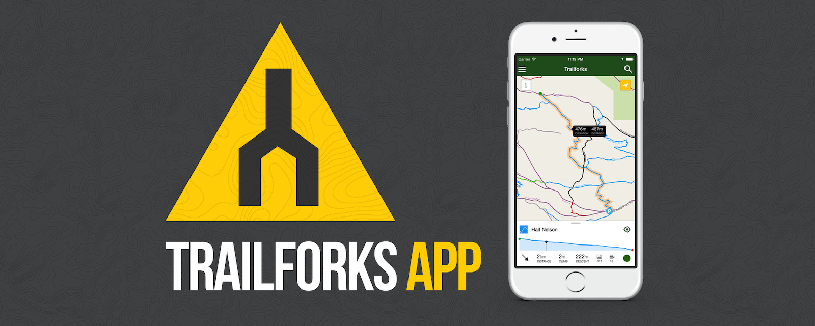
A question we are frequently asked is when Trailforks will have a mobile app. Well that time has come, with the first release of our mobile app for iOS & Android!
Trailforks publicly launched in Nov 2014 and we wanted to gain a critical mass of trail coverage & usage before focusing on the app. Additionally building block features such as the trail routing, recommended rides & tile servers were needed first. We are avid bikers and have put a lot of thought and testing into what are useful features when out on the trail. We are striving to make the best mountain biking trail map app.
This is just the first release of the app, which already has a wide array of features. Trail data is stored offline on your phone, and geo-location features work offline as well. So you can always find your location on the trail map even with no signal. The base Google Maps do require a connection, but they cache extremely well. Some features such as viewing trail photos & videos require a data connection.
Below is a list of the app's core features. As this is a first release we are open to feedback & suggestions. And of course bug reports!
App Features - 
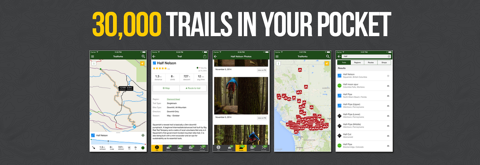
The largest database of mountain bike trails in the world, including thousands of biking related POI's - Offline trail maps and info. Region updates are incremental and fast - See your GPS location on the map, for trail navigation - Display trail & route elevation profiles and 'scrub' along them to see the location on the map - View local routes that local bikers have created - View trail ridelogs from users and discover how to ride a new trail - Automatic trail routing from your location (or nearest parking lot), to the trailhead of your choosing - Sync and view your saved 'Ride Plans' - Lookup region & trail info including routes, photos, videos & more - View trail status & reports! Always be informed of up-to-date trail conditions & closures - Submit trail reports & conditions from the app, including taking photos of trail issues - 
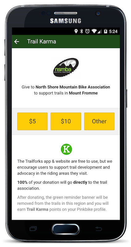
Support the areas you ride, by donating 'Trail Karma' - View nearby bike shops on the map, quick links for directions or phoning the shop
YES! Like the website, the Trailforks app is completely free to install and use. You don't have to pay for the region downloads, or to unlock advanced features.
Instead we want to encourage and build the culture of giving small donations to the places you ride throughout the year using our Trail Karma program. The app does have some banners and buttons encouraging you to donate to support a particular trail or region. Your donation will go directly to the local trail association, Pinkbike/Trailforks takes no cut.
Right there, is the mountain bike invention of the year.
Sorry to the mountain bike industry for all your efforts, but Pinkbike and Trailfork will have the award, and the mountain bike trails my money eventually !
THANK YOU !
@makripper: It's not a scaled web app. The trailforks app has native mapping for ios and android. Totally self contained app that you can use fully offline, without any data/web.
Per Radek's reply, I used the App in Whistler during Crankworx to help navigate the valley trails and I had my cellular data off (after downloading the region using my condo's wifi).
Offline cache is nothing special. Android and iphone and BlackBerry, maybe even windows does this already with their native GPS tracking. Google map app takes advantage of that already. It's cool and all that it's on your phone, but I've already used trail forks through my Web broswer with google maps open and pretty accurate with my location. This pretty much ties the two together.
@makripper - The key to this is the content and the relatively easy user interface. Right now, I spend a bunch of time dropping trail content I've sourced or created back and forth between computer and a topo app on my phone. Now I don't have to hassle with that most of the time, the content is already downloaded and on my phone, very little planning is required to get out and ride a new trail.
Meh, just a ploy to make more money off the pb userbase. Got users to create trailforks content now another vehicle for advertising. R.I.P. illegal trails as well.
It is true mtbp app has been out for awhile and its been a disadvantage for Trailforks until now. But the Trailforks app has a lot more unique features and does everything their app does. Our app also has a focus on giving back to local trail associations. For people outside the USA it is a game-changer, mtbp only has less than 1,000 trails outside the US, Trailforks already has 15,950.
@themountain the users who added the trails must have not done it properly. Anyone can submit an edit to a trail, fixing its region hierarchy attachment. I have tested the app on 4 phones and have very little battery drain. feel free to email feedback@trailforks.com with your app usage battery details.
@mtbman1980 Cumberland is blanked out at the request of the local trail association while they are in negotiations with the land manager. We respect such requests and have features built for it. Sucks as a user right now, but in the long-run you will benefit by not having the trails closed! They will be made visible again eventually, hopefully soon!
You can sorta create one if you have an iPhone. Not sure about other phones
Step 1: go to pinkbike on your phone. Step 2: click the icon at the bottom of your screen. It looks like a box with an arrow pointing up. Step 3: click the add to home screen button
Have you ever tried adding trails to MTBP? They're the worst. If the trail description isn't up to their ridiculously high standards, they won't approve it for adding. Also, they limit how many trails you can add at a time.
If you like riding you should just be grateful! Who cares if Trailforks gets the credit, they are designing the website and all that stuff! WE SHOULD BE GRATEFUL IF YOU ARE A MOUNTAINBIKER
@makripper The whole idea behind trailforks is to create tools to let local associations to manage trails better, have more resources to maintain them and create new ones. Provide info, stats and reporting the locals and association can use to get more funding and support from city, state, federal levels and have this info to deal with land owners better. The final goal to have full time paid local builders/crews in every location. On the user side, trailforks provides a way to explore legal trails easier, faster and better. This means more people riding, traveling, using bikes and products more, supporting local tourism and economies. All this grows the sport, bike industry, tourism and anyone associated with it.
Yes! This is awesome! I've gotten lost far too many times in areas I don't know, losing valuable trail shredding time!
The ability to buy a trail pass and contribute to the Trail building associations is going to be really useful for me.
For the most part i want nothing to do with electronic crap while I am riding. Strava appears to be about who has the fastest time down a trail.
This is different. If you are planing a road trip or you are checking out a whole new net work of trails. This APP will help you make better decisions on what trails to do and how to find them. Its also great when you are not certain what trail you are on.
Huge amount of effort went into making this happen.
Thank you!
@canadaka Trevor or @brenthillier Brent, Thank you! I was going to ask if this had an offline cache and while reading the first page, the question was immediately answered "Trailforks, Worldwide offline trail maps"! Most excellent work. Now we have even more of a reason to upload content and improve the information about our (public) trail systems.
You guys should setup a donation re-fridge in Squamish to drop off beer for you and your team. I'll bring you some Westcoast IPA's this weekend
Congrats Trailforks! You guys are super helpful and reply to emails and forums ASAP. It is much appreciated and as others have said, it's the best database out there. What strava lacks is exactly where you excel. Hopefully they'll wake up and partner with you guys.
I downloaded this app a couple weeks ago and have been using it on the trail. Great job Canadaka and everyone else on the trailforks team you have made something amazing. I used it yesterday to guide down some lost riders on silverstar due to a closed trail.
We don't have the resources to develop a separate app using a different mapping API other than Google. I am a Microsoft fan, but their phone platform just doesn't have enough market share to make it worth while, especially since it doesn't have Google Maps/Play services. There are rumours that Windows Phone 10 might support Android apps.
Would love a W10 universal app - PC, tablet and phone would be covered with only 1 app... but even with the growing amount of W10 users developers don't seem to prioritize it as of now - I hope that changes soon... Using HERE for offline maps would be a great bonus, but as @canadaka wrote, I can't see that happening.
I'm a big Windows 10 fan, if Google services gets ported, I'm sure it won't be hard to port our app. Universal Windows app is something I might play around with this winter in my spare time.
HI, I've been playing around with Microsoft's project Astoria, sideloading the Android Trailforks apk to my win 10 handset today. Its a little messy but I'm getting there, I've patched a version of google services framework to get it running, but I'm still having a few problems - most of the UI works but the map window is blank, I have the same problem with the gMaps app, so its probably the same issue with the api not running on my device. Trying to find a way to elevate the permission of the side-loaded files using chmod from adb shell and get Google Play Services, including the Google Play Store, to work directly on the device, but no luck yet. hopefully I'll get somewhere with it and we can all enjoy this super app! @canadaka
@ryan83 I will look at Blackberry eventually, a couple friends run it. It has the same issue as WP, no Google Maps/Play Services.
@rwb97 I found a tool for blackberry that allows one to "bake-in" Google Play services into an APK. I need to get ahold of a WP to do some proper testing.
@canadaka I'd be really interested to know what that tool is, wouldn't mind having a play with it myself. As far as having a WP 10 handset for testing goes, have you tried the emulator that's a part or visual studio 2015? (I think there may be a community version that's free, can't remember what its called there are so many versions!) - No idea if the whole wconnect or the IpOverUsvSvc method works with it but it might be more accessible for testing.
@canadaka Ahhh gMaps patcher, yeah this is what I've already been using. It does also work for wp 10 (I have maps working in google maps and strava), however in Trailforks I'm not having much luck... still trying tho Hoping that forum.xda-developers.com/showpost.php?p=62316049&postcount=141 might help in giving google services the permissions It wants. The rest of that thread is also pretty helpful!
Great idea and interface, I'm happy for the Trailforks guys and gals that they managed to launch the app. However, as of now, there is very little content regarding Europe... but a killer app for US and CAN for sure...
Europe is growing, it hasn't even been a year yet. www.pinkbike.com/photo/12637363 Trailforks already is by far the largest mtn bike trail database, but I know we have a long ways to go for Europe coverage.
well in Germany there are almost no legal trails outside of a bikepark so there is nothing to show besides the illegal trails that should better be kept secret
Yeah, okay, I get that it's harder for North Americans to cover some trail ground in Europe, I just hope it catches on in these parts and that we reach some kind of (EU) critical mass concerning user-base. As for legal/illegal, it'd be awesome if there would be a feature which would allow trail builders and -spotters to manage accessibility of their information (Public, Only Friends, Only Friends and Friends of Friends, etc.). I personally see no shame in asking someone for access/location to "semi-legal trails" in Europe, which is the large majority after all....
I had to limit the app to Android 4.4 and above for now. A large number of users were having map loading issues with older versions of Android. So until we can figure that out, we're requiring 4.4
really! it works for you fine, not a blank white map? Maybe I will make a separate build for those Android users on older versions that wanna see if it works for them. I just didn't want the Play Store clogged up with bad reviews from people on old phones where the app is likely not too work.
I know i'm probably getting flamed for this, but I have MTN Bike Project on my phone, and this app seems extremely similar to it. Just putting it out there... This is more full featured no doubt, but mtn bike project is very similar.
Mountain bike project has some concerning policies with who they let into their garden due to their IMBA affiliation. Clubs that aren't IMBA affiliated are essentially stuck outside. It's important to not restrict that, especially these days, when IMBA is making some very questionable decisions.
As with anything else, all similar items will get a proper shake and the best will rise to the top. The others may do some things better at which point everything should consolidate. Trailforks are non exclusionary (though you can hide, flag or mark unsanctioned trails) and they have a wide range of function and user ability. I dont see any apps offering anything better or even a comparable trail database. Strava only works in small segments and lacks the entire trail networks, heck it's made for road biking after all.
I notice in trail forks if you want to pull up the ride description, it has to load a web page? Not even any description on some of these trails. Comparing to mtbproject that is lacking. I will give trail forks time as people continue using and contributing.
Not sure about the user interface but if a trail doesn't have a description, it's because the uploader didn't add one. The trails are user generated and edited, so if you ride it, you can go back and enter a description yourself, rate it, make comments etc. Not trailforks fault.
Trail data is becoming more and more complete. Trail associations are taking over admin for more and more of the regions and they are curating and making sure all the info and data is accurate. They are the people that know what's best for a local region.
@canadaka Is there a plan to take on Strava functionality as well (native in app functionality to measure your trail times against other riders), or do you feel that dilutes the intention / direction you're taking the app in?
No plans to do gps ride tracking in the Trailforks app, there are already so many apps that do that. We instead communicate with those apps like Strava via their API and the Trailforks website. You can link your Strava account on the TF website then when you login to the TF app you can view your recent ridelogs.
But the main focus of the Trailforks app is trail maps, navigation & discovery.
I'm not sure i fully understand how it works. Ok, So you can see where there are trails near you. But then, can it record a new one if i'm riding in "feeling lucky" mode ? And if you select an existing trail, does it tell me where to turn when i'm riding?
@fracasnoxteam , yes. If you are on the trail, the app will show you a marker exactly where you are on the map. It's using the phone GPS to locate you.
@alexisfire no not Strava but @radek answered me. I'll be located on the map and I'll see if i'm not getting lost (and make shocut if necessary/more fun). My second question was about recording a new trail: can I start recording, go ride, stop recording and validate "My new trail" (and possibly correct it once at home, and possibly on my computer, possibly with 1 sugar and milk please, thank you.) Edit: I'll go check the forum Thanks for the job anyway!
@fracasnoxteam: Ahahah not asking for a voice telling me what to do (maybe Warner's voice... ). But my question is more "will I see me real time on a selected trail?"
Warner's OK, but how about Claudio for the voice over?
I just started adding trails but now I want to add the shuttle spots for those trails. I work with a shutle for those trails as an IMBA ICP1 guide. Can we tag info to the shuttle spots to let people know about the service?
You can tag shuttle spots when uploading content under the "POI", or point of interest. It's called "Shuttle pickup / drop off", they don't let you designate which it is beyond that, but at least there's the option to begin with.
I had a bad first experience with it, took my 45 minutes in the wrong direction when trying to find a new trail. Looked like someone just dropped the location where they thought the trail should be. wasted valuable shredding time and a bunch of gas trying to get myself to the right place. hopefully they dont let just anyone update trail locations and info
The app is user based. Content is added by riders, trail builders and local associations, basically anyone can submit content. The content submitted needs to be confirmed by other users or approved by the admin for that region. If you happen to come upon information on Trailforks that is inaccurate then by all means take a second and submit a more accurate revision, I'm sure other riders will thank-you.
i already emailed the riding club that looks after the area to have them hopefully update it (cause its a pain to do it on the app) so hopefully no one else drives lost in the mountains for 3 hours like i did
I've been using the app for weeks. It helped me tremendously the two weeks I spent in Whistler Village. At the top of Blackcomb trying to figure out how to get to MicroClimate, pulled out the app, I go this way! Trying to figure out how to get to the start of the Toonie race without having to ride on the highway, no problem.
I'm also working to upload our trail systems back here in Hawaii and then integrate the trailforks widgets onto my website so users can not only see maps but trail statistics. Even report on trails conditions.
Not to mention the developers are %100 dedicated to listening to feedback and making this the best trail mapping system out there. This is only the first release, it's only going to get better.
I live in the Peak District. 555 sq/miles of the most diverse and rich natural MTBing in the UK. Sadly there is just one trail listed in the whole area which is 2 minutes long. I'll save this for the next time I go to Morzine.
Great to see the app at last, but one issue so far, I posted a video of a trail on the site some time ago, it shows on the app that there is a video but when I click on said video, it says "no trail videos" ?? Any ideas ?? It works fine on the site on my laptop.
The only thing I have a little trouble with is using the ridelog feature. I really like the ridelog feature, but on congested trail systems it can be hard to follow the log to see how riders linked up the different trails because the log points where spaced to far apart. It would be cool to have a "play button" that starts a blue circle at the start and traces the rider throughout the ride back to the finish, so you can see exactly which directions they linked each trail. Make it where you could speed the play log up or down.
It helps to slide your finger along the yellow elevation graph in the infoWindow of the ridelog, this will show that location on the map. So you can find of create your own playthrough. But good suggestion, maybe a playback feature would be a nice addition.
We have a play idea with auto pan on a list, but one thing that may help now is to scrub your thumb on the elevation graph of a ride log and it will show a corresponding point on the map/log. Scrubbing left to right basically plays/traces out the ride.
Any reason why when I try to log into the new app, yes using my pinkbike login as instructed, it just keeps giving me the notice to use my pinkbike info. It wont let me into the app, and wont let me download any regions.
you don't need to login to download a region or use the app. Login is only required for submitting trail reports or viewing your personal routes & ridelogs on the map.
Are you sure the app has internet access? I don't see any login attempts in our logs from your username. Once you download a region you can use the app offline, but to initially download a region or to login, you need online access.
Also, Canadakais there a way to access trails that are essentially linked into 1 ride? For example, when I look at Monarch Crest, which for most people is 1 big ride but combines several trails (monarch crest, rainbow etc) it only shows the individual trail sections but not the whole ride.
Same thing happens for the "big loop" at Buffalo Creek that combines nice kitty, gashouse, CT etc into one big loop but the app doesnt seem to recognize those.
this is exactly what the "routes" system is for www.trailforks.com/routes routes will also be sync'ed to the app. You can also "fav" a route on the website, then on the app it will sync to the "My Routes" section accessed via the side-menu.
Great work @Canadaka . I used it in Post Canyon last month. It seemed that the database is still building.. What's the process for loading new trails from Ride Log? I may have missed it in the app demo.. It moves kind of fast.. The button press dot is kind of hard to see, can it be bumped up to a bright green dot with a circle around it, or something a little easier to see, so you can track what's going on a bit better? A voice-over would be nice too. I'm not being critical, you've done a great job.. Just a couple thoughts to help. Cheers
We will start creating feature specific videos in the help section www.trailforks.com/help where you can also find all the info on how to add new trails to the database. Trails are added via the website not the App. But once a new trail is added and approved, it can by synced to the app right away.
I may make another app demo video with voice over, much shorter just going over the biggest features. That current video is long and would be hard to narrate without any screw ups, many takes would be required! I'm also not the best at voicing video
This is a fabulous app and I Iove using it. Apetite comes with eating, so what about adding features for navigating a course with voice directions , building a course from a set of trails? Another thing, Google maps kinda suck for off road people, so how about switching to OSM? Another random thought - add an option for downloading a gpx so it can be opened with OruxMaps. Sorry for the geek talk...
voice directions would be a far off feature, I've definitely thought about it. I already can generate turn directions, which is part of your 2nd question, we already have a way to build a course: www.trailforks.com/ridelog/planner when you save a rideplan it will sync to the app (if you login).
We are very close to releasing our own background map, which we have custom made for Trailforks with mountain biking focus, this uses some OSM data, contours, terrain shading. You can download a trails GPX file off the website, you must login first.
@canadaka been using and loving the app for a while now. The UI is much easier to use than the mobile site. My only gripe so far, is that when browsing images of a trail, my scroll gestures tend to be interpreted as taps on the photo. I know from the web/javascript side of things there are some libraries that deal with touch intent that help distinguish the two. Not sure if the same thing exists on the native side of things but it'd be great to see that wrinkle ironed out. Thanks for the great app!
4.3 and older is already over 2 years old. According to Google's stats 4.4 is 42.6% of the Android install base still though I have tried to find the problem with no success. I will give it another crack.
Amazing. Now renders all pay (**Cough**trailmapps.com**cough**) apps useless. Thank God for Pinkbike and Trailforks .... saving the 'industry' by bringing back the MTB love!
Not really: The Trailmapps apps still have the huge advantage of having offline maps! In my experience the google maps in Trailforks don't cache anywhere near well enough. Mind you, I've been using it while on holiday in Canada, using a UK phone with no data connection (it's just way too expensive in Canada - I used wifi where I could get it).
Also, many of the Trailmapps apps have suggested route guides. As a tourist it can be really hard to know which way many of the trails work best, and more importantly how to link them all together.
Trailforks app has 3 different ways to help a rider navigate a new riding area.
1. Routes: Areas have a list of suggested routes determined by local riders, trail associations, tourism boards, etc.
2. Auto Routing: If you are new to an area, the app can auto route you to any trail from the closest parking lot or from your location on the trail network. This is smart routing in that it will not route you up downhill trail even if they are shorter distance. The system knows direction, difficulty, and traffic of trails so it can route you correctly.
3. Ride logs: Any trail has ride logs associated with it. These are rides that locals have done that encompass a particular trail as well as other trails that are naturally linked up. You can browse and view these and this is the quickest way to get "local knowledge" of the area.
Thanks - I wasn't aware of 1 & 2. The third one, ride logs is pretty good as long as you've got a live data connection (I rarely do when navigating with the app, UK or elsewhere). They don't seem to cache at all when you're offline or the app gets killed while it's in the background.
Is there somewhere official to offer feedback and/or make suggestions for the app?
If you load a ridelog on the map (the yellow line), it will stay cached offline, even if you close and re-open the map. Listing and fetching a trails ridelogs does require a data connection, but once you select one, its temp cached until you remove it from the map.
Ah - I had the app quit when it was in the background (probably because I was using google maps to get to the trails in the first place) and it lost the yellow line :-(
Great initiative!!! I have four great trails I ride on a weekly basis, they are not on the app. How do I add trails for the benefit of you-all? The missing trails are on all the other apps (Great Brook Farm for example)
You use www.trailforks.com website to manage (add, edit, control) all the trails in a given region. The app then updates with all new trails and information with a simple swipe.
The nice thing about how the syncing on the Trailforks app works is one a trail is added on the website, you can sync your app downloaded region and get that update right away. It will also occasionally sync regions in the background, so you always have the latest trails.
Really great app, used it a couple weeks ago on a zone I hadn't been at in a while. Refreshed my memory right away when I checked out the app and started exploring!
Great app! However, a "Check In" button or another way to generate trail-usage data (without sync with starve etc/or log complete routes.) would be really nice. :-)
you can "check-in" to trails manually on the www.trailforks.com website, goto a trail page and there is a button. This manual checkin feature is not currently in the app, but we'll add it.
Is this article a paid advertisement or something? I don't remember seeing any mention of mtbproject's app that's been out for years. It's basically the same thing.
Trailforks is owned by Pinkbike. I actually started Trailforks before mtbp even existed, its now part of Pinkbike and larger than mtbp. Trailforks website does a lot more and so does this app. More features, way better UI, twice as many trails and growing faster.
Comparing the two just looking at my local trails, Trailforks has one or two trails that MTB Project doesn't have, but it's also missing some stuff that MTB Project has. Must just mean that my area has better coverage on MTB Project than others.
The UI does seem a bit more refined, though, I'll give you that. MTB Project has this bug recently where the map will randomly just scroll off like 20 miles in a random direction sometimes. It's super annoying.
I think if you use our app awhile on the trail you will notice there are lots more useful features and data, along with a better UI and small tweaks to make the experience less annoying. Small things like if you close the app or it closes because you switched to say Instagram, when you re-open the app, it will remember where you were currently viewing the map. We built in many small features like this that one probably won't even notice.
Sounds pretty awesome. I'll definitely be keeping Trailforks on my phone, but I'll probably keep mtbp too if for no other reason than to have the trail coverage of both apps. But so far I think I'm already liking Trailforks more for the better UI and more accurate difficulty ratings. It seems like mtbp has a tendency to rate some of the trails in my area as harder than they actually are.
Unfortunately many parts of Cali are a trail access quagmire. There are many more trails added in California than what is publicly viewable, so many of the trails are hidden because they are illegal
But I'm sure there is lots of mission legit trails to be added, takes time. What are were you referring too? I can see if we have a contact there.
Granite Bay rec area, tons of trails there.
Salmon Falls, same general area just on the other side of Folsom Lake from the Granite Bay trail system
South Fork Trail system - across the river from Salmon Falls
Sweetwater Trail - same area
Building an accurate trail map with proper trail details takes time, its not something that could easily be automated or should be. Its a manual process that is best done by locals that know the trails. We try to make the process as fast as possible and provide a bunch of time saving features, like importing and cropping from a Strava ride.
Trailforks has a lot of features to help manage this. www.trailforks.com/help/view/22 We also reach out to local trail associations so they can manage the content in their area and decide what should be public. Hidden trails are not downloaded to the app.
I agree with Saruti.......
not only can it assist in finding secret trail to destroy.....it will also open up secret trails and stunts for anyone to hit, and treat like a bike park.....leaving all the maintenance to the few locals to have to work on during their limited ride time...
I think Pinkbike gave some thought to the notion of trails being taken away. Thanks canadaka for clearing it up. Trailforks is not a place for finding illegal trails. That would defeat the whole movement to make mountain biking legit and legal in the eyes of others. Bravo Pinkbike. This app will be a very useful tool when I go out of town to ride.
I had never used TrailForks previously but had a quick look recently when visiting Las Vegas, it pointed me towards some great runs real near to where I was staying (right on West side) and I loved them, met a few other locals and had a nice chat, there was not swarms of people ruining the trails, lets face it this rarely happens, even in hugely popular resorts such as Morzine, France, the vast majority don't ride the unofficial secret trails and there is very little damage done and most people are happy to help with building and maintenance if asked.
Without Trail Forks I would of been oblivious to some great runs right on my doorstep so thanks to them and of course to the original trail builders
I think the app is a great tool and can be very helpful to riders exploring new ground..
I'm just making people aware that there are consequences that can come along with it....
I know builders are definitely the minority here and most people will never understand where i'm coming from...
@redman733: I'm the community manager for TF and a Trailbuilder when I'm not working for Pinkbike. If you have concerns just send me a message and we'll sort it out for you.
This is going to be a huge issue in laguna beach. I know trailforks has a point man or two locally, but i just hope they can stay on top of it. Strava/utube has really ruined some trails.
Redman733
I see your point, In the last year I've seen a few of the trails I built destroyed by overuse, not that long ago I came across a few riders and asked how they found the trail and they said it's posted on trail forks, and sure enough it is. The trail has never been so busy and a lot of the features have been destroyed, and I don't have the time to maintain and rebuild it constantly. So there is definitely a downside to this that most people do not realize as they do not do any sort of trail maintenance for themselves. That being said I would probably want to use trailforks while riding away from home to find all the sweet trails, so I guess it has it's advantages, it would help if riders could remember to respect the features others have built, do not modify existing trails, and be courteous on the trail when it's busy.
No I didn't I had trail report
cute how they deleted other comments like this.
You can sorta create one if you have an iPhone. Not sure about other phones
Step 1: go to pinkbike on your phone.
Step 2: click the icon at the bottom of your screen. It looks like a box with an arrow
pointing up.
Step 3: click the add to home screen button
On the user side, trailforks provides a way to explore legal trails easier, faster and better. This means more people riding, traveling, using bikes and products more, supporting local tourism and economies.
All this grows the sport, bike industry, tourism and anyone associated with it.
Thank you!! Very well done!!
You guys should setup a donation re-fridge in Squamish to drop off beer for you and your team. I'll bring you some Westcoast IPA's this weekend
Using HERE for offline maps would be a great bonus, but as @canadaka wrote, I can't see that happening.
@rwb97 I found a tool for blackberry that allows one to "bake-in" Google Play services into an APK. I need to get ahold of a WP to do some proper testing.
Thanks!
Trailforks already is by far the largest mtn bike trail database, but I know we have a long ways to go for Europe coverage.
will Android 4.1 continue to be supported?
I have the V1.0.4 installed to try ATM
cheers
But the main focus of the Trailforks app is trail maps, navigation & discovery.
time is an illusion
My second question was about recording a new trail: can I start recording, go ride, stop recording and validate "My new trail" (and possibly correct it once at home, and possibly on my computer, possibly with 1 sugar and milk please, thank you.)
Edit: I'll go check the forum
Warner's OK, but how about Claudio for the voice over?
"Ahhhgg...you're taking the French line!"
I'm also working to upload our trail systems back here in Hawaii and then integrate the trailforks widgets onto my website so users can not only see maps but trail statistics. Even report on trails conditions.
Not to mention the developers are %100 dedicated to listening to feedback and making this the best trail mapping system out there. This is only the first release, it's only going to get better.
The only thing I have a little trouble with is using the ridelog feature. I really like the ridelog feature, but on congested trail systems it can be hard to follow the log to see how riders linked up the different trails because the log points where spaced to far apart. It would be cool to have a "play button" that starts a blue circle at the start and traces the rider throughout the ride back to the finish, so you can see exactly which directions they linked each trail. Make it where you could speed the play log up or down.
Congrats on the app.
Help anyone?
Are you sure the app has internet access? I don't see any login attempts in our logs from your username. Once you download a region you can use the app offline, but to initially download a region or to login, you need online access.
Same thing happens for the "big loop" at Buffalo Creek that combines nice kitty, gashouse, CT etc into one big loop but the app doesnt seem to recognize those.
Any thoughts?
routes will also be sync'ed to the app. You can also "fav" a route on the website, then on the app it will sync to the "My Routes" section accessed via the side-menu.
Most of our best DH is technically illegal as it's either out of bounds or on private property...
I may make another app demo video with voice over, much shorter just going over the biggest features. That current video is long and would be hard to narrate without any screw ups, many takes would be required! I'm also not the best at voicing video
We are very close to releasing our own background map, which we have custom made for Trailforks with mountain biking focus, this uses some OSM data, contours, terrain shading. You can download a trails GPX file off the website, you must login first.
I have tried to find the problem with no success. I will give it another crack.
Also, many of the Trailmapps apps have suggested route guides. As a tourist it can be really hard to know which way many of the trails work best, and more importantly how to link them all together.
1. Routes: Areas have a list of suggested routes determined by local riders, trail associations, tourism boards, etc.
2. Auto Routing: If you are new to an area, the app can auto route you to any trail from the closest parking lot or from your location on the trail network. This is smart routing in that it will not route you up downhill trail even if they are shorter distance. The system knows direction, difficulty, and traffic of trails so it can route you correctly.
3. Ride logs: Any trail has ride logs associated with it. These are rides that locals have done that encompass a particular trail as well as other trails that are naturally linked up. You can browse and view these and this is the quickest way to get "local knowledge" of the area.
Is there somewhere official to offer feedback and/or make suggestions for the app?
You can email feedback@trailforks.com or post in the support forum www.pinkbike.com/forum/trailforks-feedback
es impresionante y muy útil tener al alcance esta aplicación
I have four great trails I ride on a weekly basis, they are not on the app. How do I add trails for the benefit of you-all?
The missing trails are on all the other apps (Great Brook Farm for example)
However, total game changer here, really stoked about your work guys thank you so much!!!
Great apps, many thanks for the builders, both app building and trail building
feedback@trailforks.com
www.trailforks.com/help
But I'm sure there is lots of mission legit trails to be added, takes time. What are were you referring too? I can see if we have a contact there.
We're still waiting
We also reach out to local trail associations so they can manage the content in their area and decide what should be public.
Hidden trails are not downloaded to the app.
I had never used TrailForks previously but had a quick look recently when visiting Las Vegas, it pointed me towards some great runs real near to where I was staying (right on West side) and I loved them, met a few other locals and had a nice chat, there was not swarms of people ruining the trails, lets face it this rarely happens, even in hugely popular resorts such as Morzine, France, the vast majority don't ride the unofficial secret trails and there is very little damage done and most people are happy to help with building and maintenance if asked.
Without Trail Forks I would of been oblivious to some great runs right on my doorstep so thanks to them and of course to the original trail builders
Flagship iPhones (i.e. not the poverty "C" models) often cost LESS than flagship Android models.