Pinkbike Announces 'Trailforks'
Trailforks is a trail management system for riders, builders and associations. It aims to provide the very best tools to inventory, maintain, promote and showcase trail networks. Tools such as statistics empower each group to have accessible data to show local city councils, governments, tourism boards and parks, conveying the popularity and potential economic impact of cycling on their area in order to receive further support to grow trail networks.
Trailforks is not just any trail mapping website, it's a user contributed database that puts the control into the hands of the people who have worked so hard to preserve and maintain the trails we love. Did you know that many trail Associations don't own the GPS data for the networks they support. Many areas have paper maps & guidebooks owned by private interests and not all, if any, of the profits make it back to the associations. Trailforks' mission is to provide a direct funding model to put 100% of the money back into the association via Trail Karma. On Trailforks users can directly support the people that are swinging the hammers and digging the dirt to maintain and preserve the trails we all love to ride.
www.trailforks.com
Why Another Trail Website?
Trailforks is built by mountain bikers for mountain bikers with a singular focus on mountain biking, providing unique features, a modern design and a focus on maps. Trailforks is created and supported by Pinkbike, a large, well known name in mountain biking that has the resources to make this project a success. With the experience of running a site used by millions, Pinkbike gives Trailforks the technical power to make the site fast and highly available. Pinkbike will ensure Trailforks' longevity. So many other trail sites have come and gone, never taken off, completely a paid service or are locally focused. Trailforks is free, world-wide and automatically integrated with tens of thousands of photos and videos already on Pinkbike.
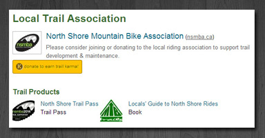
The goal is to offer unique features and tools to help promote local clubs, business and trail supporters. Trailforks promotes associations on both trail and region pages, and encourages users to join and/or donate. Trailforks also promotes local products like physical maps and guidebooks. Ultimately, it's about promoting your region and growing the sport of mountain biking. Associations can use Trailforks to help serve the locals that support them or promote their community as a mountain bike destination, boosting local economy.
We have been in open beta over the summer and Trailforks is already the largest directory of mountain bike trails in the world, with over 13,000 trails. There has been a bunch of enthusiastic users mapping their local riding areas, now is your chance to join them!
We are only getting started!
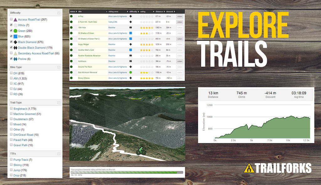
1. Explore Trails
Trail networks can be viewed in 3D
using integrated Google Earth!
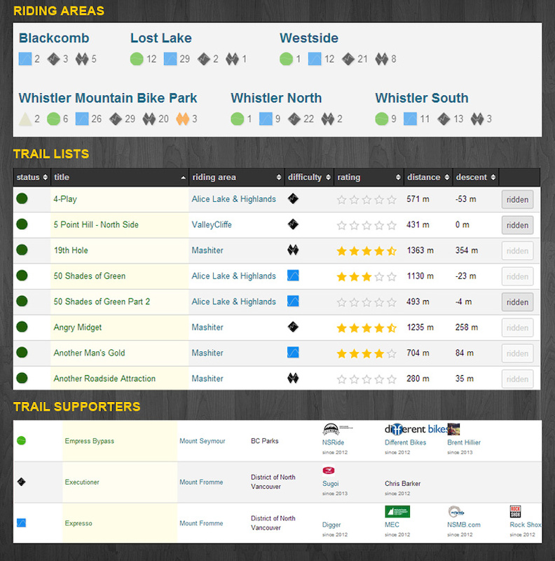
Whether you're searching for something new to ride in your local area or planning a road trip, you can browse trails from all around the world using the interactive Trailforks Map. Trails are organized into 'riding areas'. You can mark which trails you've ridden, add to your wish list, or create trail lists and save them for upcoming rides.
Trails are added by users and once a trail is submitted it goes through an approval process. The most basic approval is a crowd-sourced process where other Pinkbike users can confirm or reject submissions. If this sounds familiar it's because it works the exact same as Pinkbike's directory:Places. The secondary approval process is where the trail associations come in. Each area can be assigned admins who can edit, delete, approve and reject trails. Admins can range from a single trail builder, to the entire board of directors of a local trail association. With this feature we prevent your favourite secret trail or loamer from appearing on the site for every Tom, Dick and Joey to see, something major social fitness websites don't do. Sensitive trails can be hidden to all those except region admins.
Trails are added by users and once a trail is submitted it goes through an approval process. The most basic approval is a crowd-sourced process where other Pinkbike users can confirm or reject submissions. If this sounds familiar it's because it works the exact same as Pinkbike's directory:Places. The secondary approval process is where the trail associations come in. Each area can be assigned admins who can edit, delete, approve and reject trails. Admins can range from a single trail builder, to the entire board of directors of a local trail association. With this feature we prevent your favourite secret trail or loamer from appearing on the site for every Tom, Dick and Joey to see, something major social fitness websites don't do. Sensitive trails can be hidden to all those except region admins.
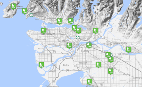
2. Explore Bike Parks
Explore Bike Parks from all over the world, whether it's the Whistler Bike Park or the Bike-Circus in Saalbach-Hinterglemm, Austria.
Trailforks also maps local skill parks, so you can find where to practice your technical skills or where to rip it up on a BMX track.
Trailforks also maps local skill parks, so you can find where to practice your technical skills or where to rip it up on a BMX track.
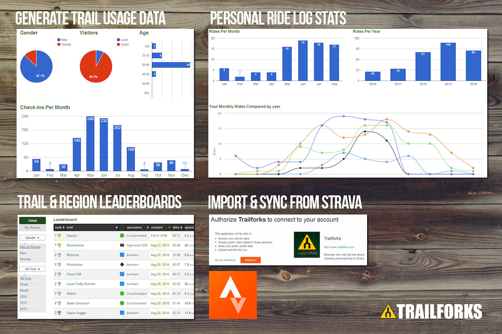
3. Add Ride Logs
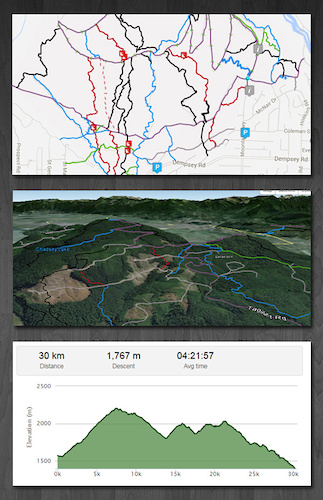
One of the key features of Trailforks is the Ride Log tool. The benefit for you, the user, is tracking all your rides in one place, the choice to share them is up to you. Trailforks easily syncs up with Strava. If you already use Strava you can add all your rides in one go with the Bulk Strava Import. See your ride overlaid onto a trail map, to easily identify which trails you rode! Use your ride log data to add missing trails to the database.
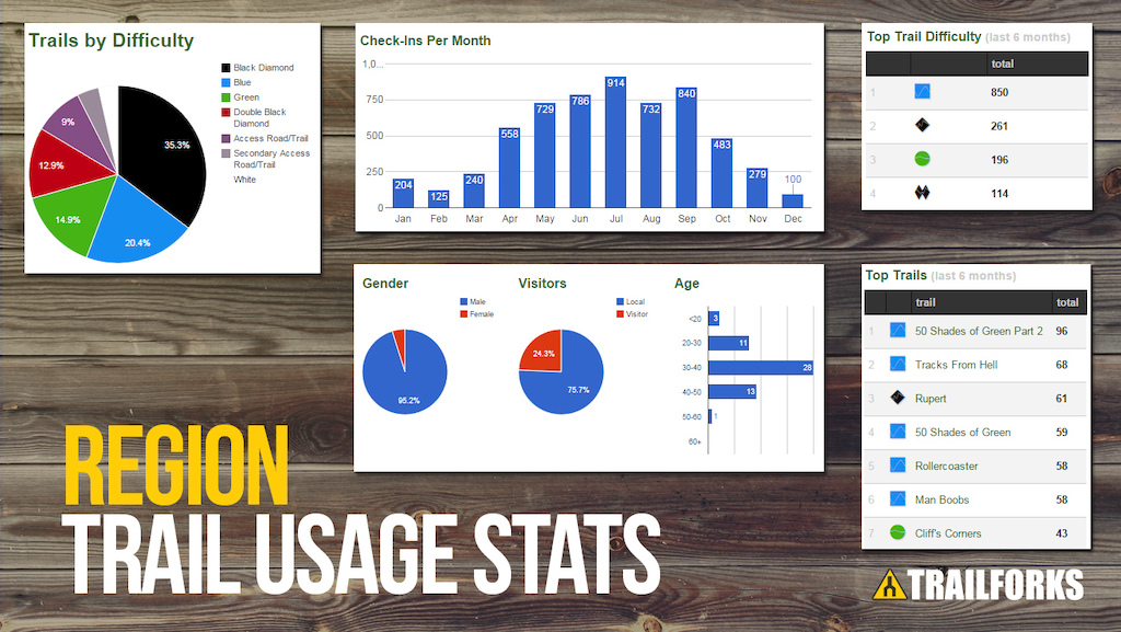
Trail Associations benefit from being able to collect important statistics on who is riding what trails and when. This trail usage data can be a valuable tool for seeking trail funding. Associations and users can easily view statistics on every trail and region on Trailforks. It doesn't matter how big or small a riding area is, gain detailed statistics, like the ones below, on all of them.
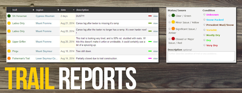
4. Report Trail Conditions
Come across a downed tree or damaged bridge? Submit a trail report. Check the status of your favourite trail before a ride and get the details on the conditions.
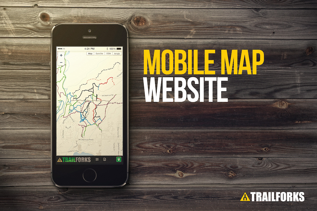
5. Mobile Friendly And Apps
Trailforks has a simplified mobile website m.trailforks.com and the desktop version of the Trailforks website has a 'responsive' design which also works well on mobile. We are currently developing mobile apps and a full Trailforks map app will be coming out this winter. In the meantime we've created this simple Trailforks Report App.
6. Photos And Videos
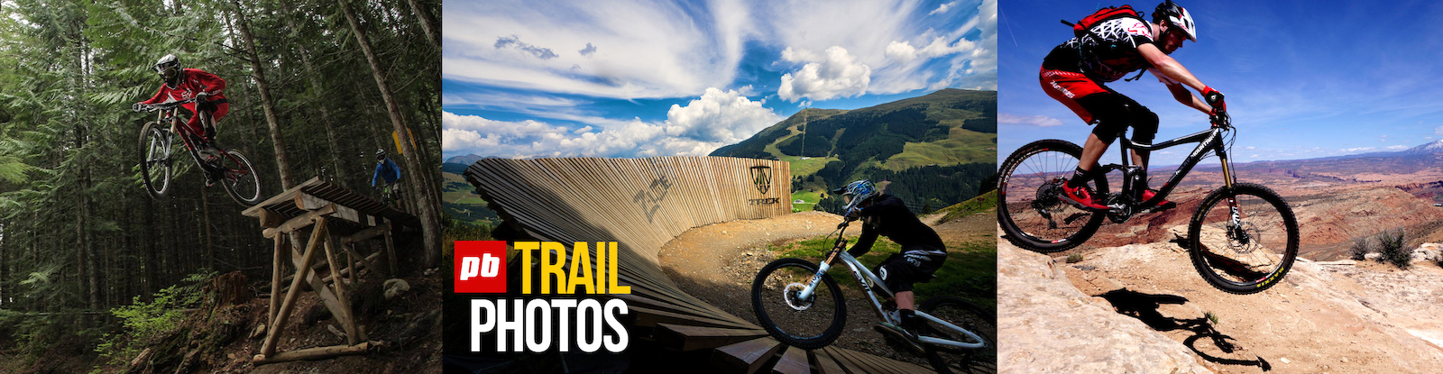
Ever notice that 'trail' field when uploading a photo to Pinkbike? Now it has a purpose! Attach Pinkbike photos and videos to Trailforks trails, regions, bike skill parks, reports or POIs. A trail info block will show on your Pinkbike photo's page.
When you add a new trail, existing Pinkbike photos and videos will automatically be matched to the trail based on the name and geo location. This means that when riders are looking for new regions to travel to, and new trails to ride, they will see these great photos and videos. A picture's worth a thousand words and on Trailforks we've harnessed the incredible power of Pinkbike's photo and video catalogue.
7. Trail Karma Donations
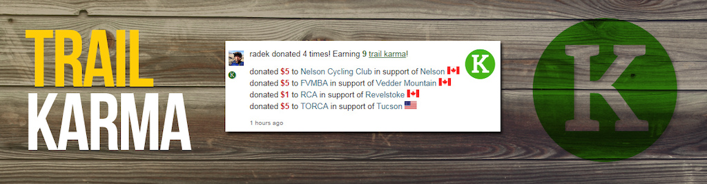
Donate some cash to your favourite riding areas to help local associations and builders maintain and develop the trails! If your association has their PayPal email setup, donations will go directly to them! No middle man, Trailforks or Pinkbike don't see a nickel. If a PayPal isn't entered, the donation is kept by Trailforks and will be distributed quarterly in a bulk payment.
www.trailforks.com/karma/
Donating will earn you "Trail Karma" which will add an icon beside your name giving you recognition. On region karma pages, one can see how much has been donated, the top donated to regions, associations and more.
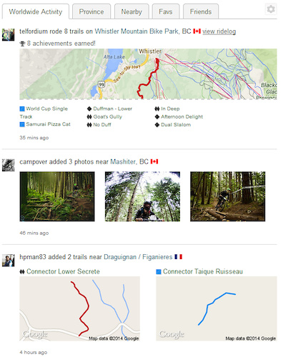
8. Activity Feed
Keep updated on content being added to Trailforks with the 'Facebook style' activity feed. Narrow down the feed to your nearby area, your favourite riding areas or just your friends activity.
Trailforks also sends Pinkbike dashboard notices for various actions. You can 'subscribe' to trails or entire regions to get email notifications of new content added, or a report added to a trail you help maintain.
Trailforks also sends Pinkbike dashboard notices for various actions. You can 'subscribe' to trails or entire regions to get email notifications of new content added, or a report added to a trail you help maintain.
9. Trail Association Features
How does an association generate revenue for a region?
- Trail Karma (donations)
- Trail Supporter program
- Mobile App
How does an association take control and become an admin for a region?
Associations can apply to become an admin of any region on Trailforks. Our staff will then contact applicants and verify their affiliation with the appropriate trail association.
How does an association receive money from trail karma?
Simply provide us the PayPal email address for your association or you can enter it yourself by editing the Places listing.
Now when users contribute money to a region or trail managed by an association, the user is sending the money directly to the associations PayPal account. 100% of the contributions on Trailforks go to the associations; no other party is involved.
What about illegal trails?
There are always going to be unofficial trails and we believe it is better for an association to be aware of them and manage them accordingly.
We have talked to many associations and have built tools to allow various ways of handling illegal trails.
- a trail can be visible
- a trail can be visible with a warning that it is a not sanctioned, not maintained and to ride at own risk
- a trail can be visible, but clearly marked as closed and marked do not ride
- a trails location can be hidden, but its name is still visible in lists for users to add photos and reports.
- a trail can be hidden but available to only certain groups
If a trail is hidden, users can't keep adding the trail. Having the data in the system allows associations to inventory their network and have the data available when needed for the future.
How does Trailforks make money?
No money is made directly from Trailforks. Empowering and supporting the trail associations with a system and tools to maintain, create and legitimize the trails is a good thing for the industry and society. More trails, more riders, more riding, more bikes, more industry growth, more support for trails. Repeat often!
How can an association use the data?
At Trailforks we believe in access to data and use a Share-Alike policy. Access the Trailforks data using our many widgets, RSS and KML feeds and JSON API. As well as data dumps for entire regions in KML or OSM formats.
Trailforks has various statistics pages for each region and each trail as well as ride log/checkin trail usage stats.
Vancouver's North Shore trail stats: https://www.trailforks.com/region/north-shore/stats/
Squamish ride log stats: https://www.trailforks.com/region/squamish/ridelogs/
Conclusion
There are SO many features packed into Trailforks, these are just a few to get you started. Start exploring the site to find more, and follow our Facebook page where we highlight features. We also document features on our help page.
Like what you see so far? Just wait for the more inclusive mobile app, which will be available this Winter. The development of Trailforks is continuing and we have many more exciting features to come!
From everyone here at the Trailforks team, we hope you enjoy the site and discover how you can use it to find, share or track your ride. If you have any questions or concerns, visit the feedback forum or send our Community Manager an email at brent@pinkbike.com.
Riders, check out your local trails here: https://www.trailforks.com/local/
Associations, learn more about Trail Karma here: https://www.trailforks.com/karma/
Builders, add and share your latest creations here: https://www.trailforks.com/contribute/

Author Info:

Must Read This Week
Sign Up for the Pinkbike Newsletter - All the Biggest, Most Interesting Stories in your Inbox
PB Newsletter Signup
What reason does a local MTB group have to keep trails hidden from other users?
Every trail should be able to be edited by anyone. Maybe a local MTB group can moderate, but to allow them to hide trails from other people? Ridiculous.
A mobile map app is in the works over the winter. But there is also the mobile map site m.trailforks.com
- offline mode
- trail reporting
- trail photos/video
etc.
Illegal as in selling crack? Or robbing houses?
We're riding dirt bikes in the woods for f*cks sake
Please find another word like 'unoficial' or something
You can pretend you are going to try to keep them hidden, but consider this scenario: Bob spends 3 years building a trail and doesn't even have computer access or many friends that he even wants to share the trail with. 'Administrator' Mike, who doesn't even know Bob, discovers his trail, thinks it's great, and decides he wants to share it with everyone on Pinkbike. Trail gets overrun with users and is shut down by land agency or land owner. In this situation TRAILFORKS becomes TRAILF**KS! When it comes to the internet, I have learned to not trust people' s best intentions. Or websites best intentions for that matter.
And for those who say unsanctioned trails are bad for mountainbiking, I will simply remind you many of the best trails around the world started as illegal trails built by rogue builders.
Some times to much knowledge is not a good thing.
I prefer to be shown by some one who knows the trail to show me a new trail.
Land managers knowing what we are doing can be good but dangerous to the status of trails built by individuals that just want to ride with out all the bureaucratic BS.
Most trails I ride were build with out any ones authority. Now some fat office bound city official that is payed with my tax dollars is going to decide which trails are good for the public.
Trailforks doesn't make money, there are no adverts on the site, not saying there never will be a single ad ever, but it would never be plastered with ads, maybe more corporate sponsor prizes for contests and such.
We have no plans to sell the trail data, we have a Share-a-like policy, others can use the data if they also retain free access to it.
I've already given a data dump (for free) of all the trails in BC to a new bcadventure website and those BC Offroad map books, which have a new edition coming!
Joe Schmo has to take a piss mid ride. He pulls to the side of the fire road, hops the embankment, and drops trou. Mid piss he notices the tire tracks under his feet and wonders why they're here. After poking around and spotting glorious single track that myself and friends have built and ridden to our liking, he grabs his bike and wheels it through a couple bushes...
After enjoying himself, he doesnt forget to take a few pictures, mark some coordinates, and share his "new" find with the trailforks world. Then Im out working on trail and find myself almost getting run over by the sheer volume of people who would've never given this place a thought before.
How does this service know whos in the right there ?
Unless you know the trail builder personally there is no way of knowing if it's his trail or not , how do you go about proving some thing like that?
'Region' is the term we use for all geo containers (Country->State->Sub Region->City->Riding Area)
Not to mention myridelog is telling me I went riding in a bunch or areas I've never been any where near. How does a ride in Groton, MA get interpreted as being in Nashua, NH?
@canaduka. Can you give me a rock-solid guarantee that no unsanctioned trails will ever be closed as a result of the emergence of Trailforks?
What is the vetting process when determining who becomes administrators?
How is the hierarchy of administrators determined?
Approximately how many Administrators are there in all of Canada, America, and the world respectively?
If one administrator thinks a trail should remain hidden and 10 think it shouldn't who resolves the dispute? Does the builder have any say if he doesn't have internet access?
You are essentially focing builders of unsanctioned trails who don't want them discovered to spend time on your internet site making sure they stay relatively secret.
There are undeniably positive aspects of this but I would hate to be the trailbuilder who had his trail shut down because of it.
If a trail is hidden and photos matched to it, the trail info/name is not show on the PB photo page.
Of course I can't guarantee that, we just try our best to put in place safe guards and ways to deal with it, which is more than others have done.
The whole region admin system is still a work in progress, needs to get used more to find the best procedures. But secret or illegal trail issues really have not come up that much in the past year.
Its mostly someone from a local trail association that has applied for region access. We've only setup about 30 so far.
The same is true for the various other trail websites out there, a builders unsanctioned trail can be added. We offer some tools to deal with it. If they don't care to check the TF website, it takes only a few seconds to setup an email notice for any new trails added to a region. So I subscribe to Seymour, to monitor if anyone every posts a new trail there. So I can check it immediately and contact Mark@nsmba if needed. Another feature on my todo list is to create blackout zones, with a region you can already draw a polygon to define its area. But I wanna add a 2nd type where one can draw a zone, and have it so any trail added in that zone they get notified and the trail is flagged immediately.
Strava has been quickly destroying the previously lesser known and well guarded trail systems of the Santa Cruz area.
Singletrack that has existed for 20+ years now gets blown out, and then fenced off and shut down, due to everyone knowing where it is and the massive increase in traffic that results.
Strava Heat Maps are the enemy of trail builders!
I want something user based, but more fight club style. You must be invited to join a group and see the rides. No public access.
Hell, I'd even pay cash money for such a service!
All I'm worried about is involuntary participation. Maybe I read it wrong but thats the understanding I've gotten here. No one should be able to submit a trail to this database other than the trailbuilder.
It would be next to impossible to verify a person is a builder of a trail wordl-wide.
The builders & sponsors of a trail can be listed though, to give some credit and history, example: www.trailforks.com/trails/expresso
Will it still exist? Yep.
TLDR: no electronics on hidden trails, make sure no-one is following you.
Edit it an re'name it
"stay off or I'll kick your fkng spokes in"
Simple
So essentially, any random person who discovers a secret trail can submit it regardless of who built the trail, who maintains the trail, or whether they even know them or not. Then the boards of directors of the local trail association who administrator finds out about the secret trail and it isn't secret anymore. At the very least some of them are going to go check out the trail and more people will end up hearing about it and riding it. At worst they don't like it because it isn't a lame sustainable flow trail and they get it shut down and there are no more knarly DH trails in the area.
People don't keep secrets well, especially when they aren't the ones who put the hard work into building the trail. Combine this factor with the internet and its a recipe for disaster. They are putting way too much trust in these 'administrators', some of whom could just as well be undercover land management or law enforcement officials.
This was a couple years ago, so strava wasnt too wide stream yet and unknown to me. But thats all it took for me to have a hatred for strava and any " internet lets go find all the awesome trails and have a rad f*cking database for them so every mtb er in the region can easily find them." f*ck THAT
You can mitigate bad trail experiences by widening your scope. Check ratings, youtube, google, and regional forums for alternate info. Cross reference yields more reliable results.
There are always going to be unofficial trails and we believe it is better for an association to be aware of them and manage them accordingly.
We have talked to many associations and have built tools to allow various ways of handling illegal trails.
- a trail can be visible
- a trail can be visible with a warning that it is a not sanctioned, not maintained and to ride at own risk
- a trail can be visible, but clearly marked as closed and marked do not ride
- a trails location can be hidden, but its name is still visible in lists for users to add photos and reports.
- a trail can be hidden but available to only certain groups
If a trail is hidden, users can't keep adding the trail. Having the data in the system allows associations to inventory their network and have the data available when needed for the future."
Only the last of those options is even remotely acceptable. Location OR a name still leads to the same problem. Please don't screw this up. -anyone who's ever tried to work with an irate private landowner after the fact of trails being built.
Otherwise this looks like a cool endeavor, especially tying in regions with advocacy and building groups.
Yeah... power in numbers. Power to widen, dumb down features, build reroutes, make braking bumps etc. The city council might even acknowledge that the trail is important to users and sanction it... they'll even foot the bill for pavers and grading it 5 feet wide. If you think that is a "dramatic" response then I don't know what to tell you. How many technical downhill trails have you built, and how many people are riding them on Strava?
www.pinkbike.com/photo/9284162
www.pinkbike.com/photo/9284096
The truth is that someone who spent months/years working on a trail is probably going to have a lot more understanding of the given property ownership, be it amenable to the presence of a trail or not. Just because you found out: 'hey there's a trail over there' doesn't mean you have an understanding of what it means to have more people and/or cars around. Just because you don't know or understand the reasons in any given scenario, doesn't mean there aren't any. And remember.......someone else has a lot more blood sweat and tears in the situation than someone who just wants to ride, be it digging or working on logistics with a land owner. And yes, there are situations where a property owner is completely fine with a controlled number of riders because hey! They actually know each other! And they don't want strangers on their property. That's not entitlement, that's a relationship.
Let me state this as clearly as possible: Just because you know about a trail doesn't mean you know the story behind that trail. So have some manners and do 1% of what the builders did and find out. The reasons for wanting to keep a trail off the radar could be one of many, even one of simple timing. The argument of 'but I wannnaaaa ride it noowwwwww' is yes, absolutely, unequivocally, juvenile entitlement.
What we are talking about here is different though, and it's happened with Strava where I live and ride. This is a MASSIVE influx of riders on secret lines, and absolute awareness of the traffic by land management. I ride Laguna with all the cute trails you see on Pinkbike, and before Strava it was already absurd that someone in Florida might know where Telonics or PG are. Now there is a segment for almost every secret trail, and anyone can go test their luck. This will sound even more dramatic, but I guarantee the airlift statistics have risen as a result of that democratization. Do you think the city response will be to make a skills-building area? No.
Think this needs some elaboration!!!
You can also add photos to trails manually, either via the normal Pinkbike method, there is a "trail" field when adding a photo. Or on Trailforks you can link to existing PB photos or upload new ones from a TF specific interface that reduces the steps in uploading a photo to PB. It auto selects a "trailforks" album and can auto-populate the "trail" field.
www.trailforks.com/region/spearwood
The update system is gonna have to be on point.
This is not the first try at this type of service, but I really hope this one makes it thru.
Mtbproject is also only partnered with imba, not run by it. Its created by a private company making money from adverts on the site and their deals site. Trailforks is also owned by a private company (Pinkbike), but the website itself has no adverts or requirement to generate revenue to be self supporting. Money generated through Trailforks through features like "Trail Karma" goes 100% to the trail associations.
There are other trail sites as well, but we strongly feel we could make something better and its something the PB audience has been asking for years.
And I will quote from the article above "Trailforks is created and supported by Pinkbike, a large, well known name in mountain biking that has the resources to make this project a success. With the experience of running a site used by millions, Pinkbike gives Trailforks the technical power to make the site fast and highly available. Pinkbike will ensure Trailforks' longevity, with no requirement for it to be self supporting. So many other trail sites have come and gone, never taken off, have paid access to useful data or are locally focused. Trailforks is free and world-wide."
We are not anti imba, we are helping with one of their core missions "We inspire more people to experience the outdoors on bicycles". This is something Pinkbike has been doing for over 15 years.
If an unsanctioned/illegal trail gets posted & approved by a mod and shouldn't be there, then anyone can report it and it will be quickly investigated and taken down or marked hidden to prevent future attempts at adding it. We can't vet every trail in the world, that's where the power of crowdsourcing comes in.
We don't encourage illegal trails being added, but lots of trails are in a unsanctioned grey-zone and different regions & associations have different policies towards them, so they can decide themselves. We provide methods to keep tabs on possible illegal trails being added, subscribing to a local region to get notified when a new trail is added, marking a trail is hidden, flagging a trail so regional and site admins are notified. Over time we will build out a network of local region admins that will monitor their local areas and they can approve or deny trails themselves. We already have around 30 regional admins from local associations, bike clubs or trusted users setup with access. Trailforks has been running in the Vancouver, BC area all year with no issues of illegal trails getting added. The sky has not fallen.
....Radek.... seriously though? Do you not see that what you just said is literally like holding someone's trail at ransom?
#hideyokids #hideyowife #Pinkbikesr@pingeverything
But if your using your mtn bike for lots of road rides that aren't commutes, then were kinda out of options!
I scratch my head playing devils advocate, what are some of the drawbacks? Call me old, but I used to walk into town and hit the LBS and shoot the sh!t and get route info from them, buy a water bottle, and leave. Yet another jab to the LBS? It's a stretch, not much to critique. Nice Work!
This is a much needed improvement to trail tracking. I would like to add a suggestion, each trail should have a link to the trail stewards that maintain the region. This would make it easier for volunteers to find schedules with regional trail stewards to give a helping hand on authorized dig days.
Also trails can have 'Supporters' listed, being trail sponsors, builders & maintainers. here is an example: Severed D
http://i.imgur.com/VYIh3Ym.png
When adding/editing a region the land owner can be listed and website linked.
We will have some Trailforks stickers coming soon too!
www.trailforks.com/ridingareas
singletrack, doubletrack, mixed, machine groomed, dirt/gravel road, paved path, gravel path, other
Also trails can be added as "Access roads" or "Secondary Access roads"