Trailforks 2023 Development Updates
Words: Trailforks Trevor
Disclosure: Trailforks is Pinkbike's sister company and also owned by Outside Inc.
We've been hard at work in 2023 improving Trailforks with new features and refinements along with bug fixes. While we spend a lot of development time maintaining the platform, tweaking backend systems to be more efficient, optimizing database and other boring stuff, we have also continued to add a lot of new features. Many of these features are for everyday users, while others are built specifically for trail associations.
Here is a list of some of the changes we've made in 2023. But first, three big milestones Trailforks recently hit.
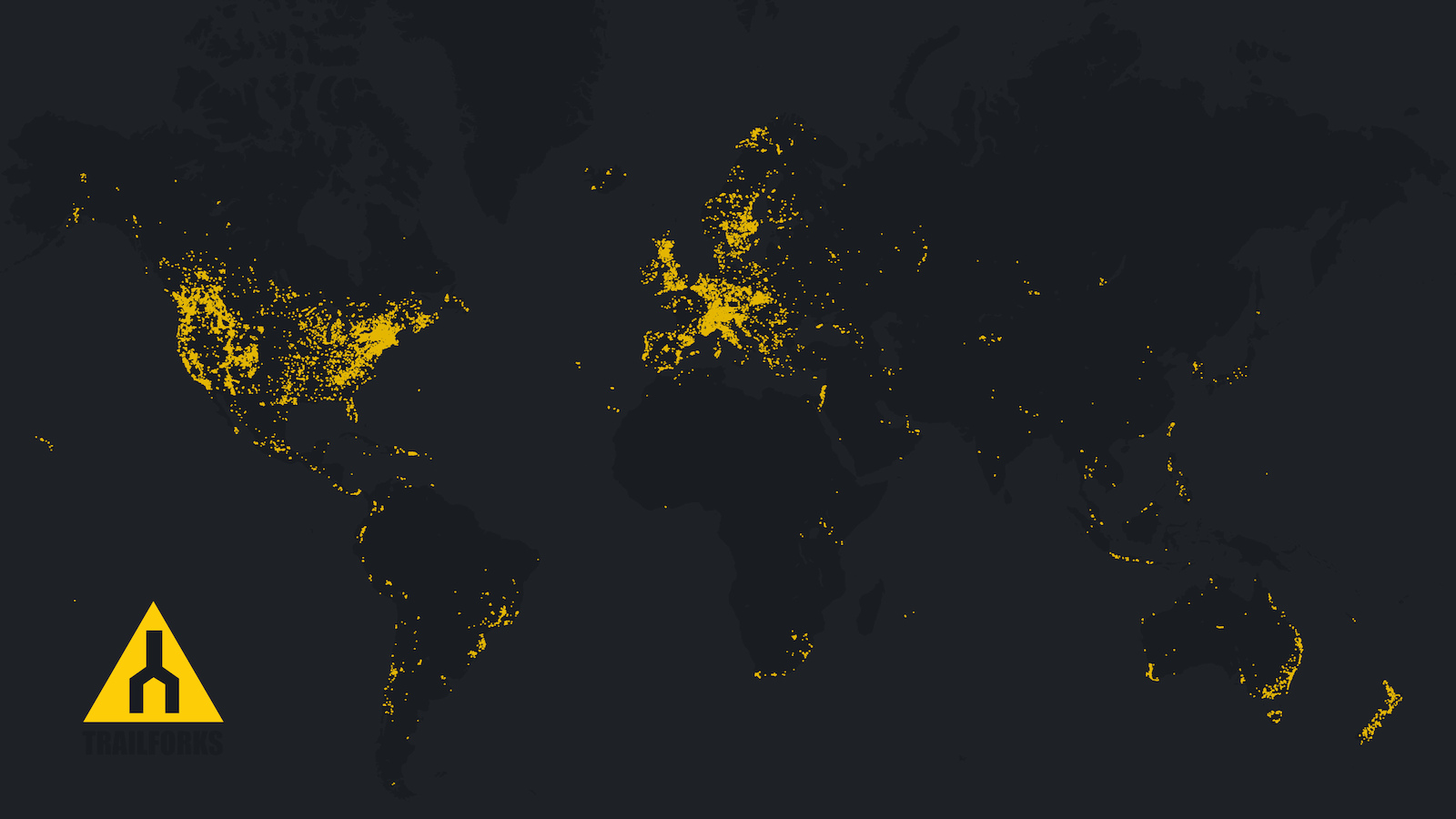
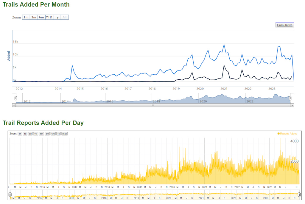
650,000 trails mapped
3,000,000 trail reports added
60,000,000 Ridelogs recorded
We have expanded our internal curation team which added 40,000 new trails. Contributing to the 102,000 total new trails added in 2023.
Website Updates
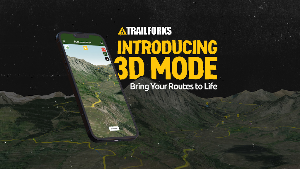
• 3D Maps on the website and app. View the trails, routes and all map layers in 3D.
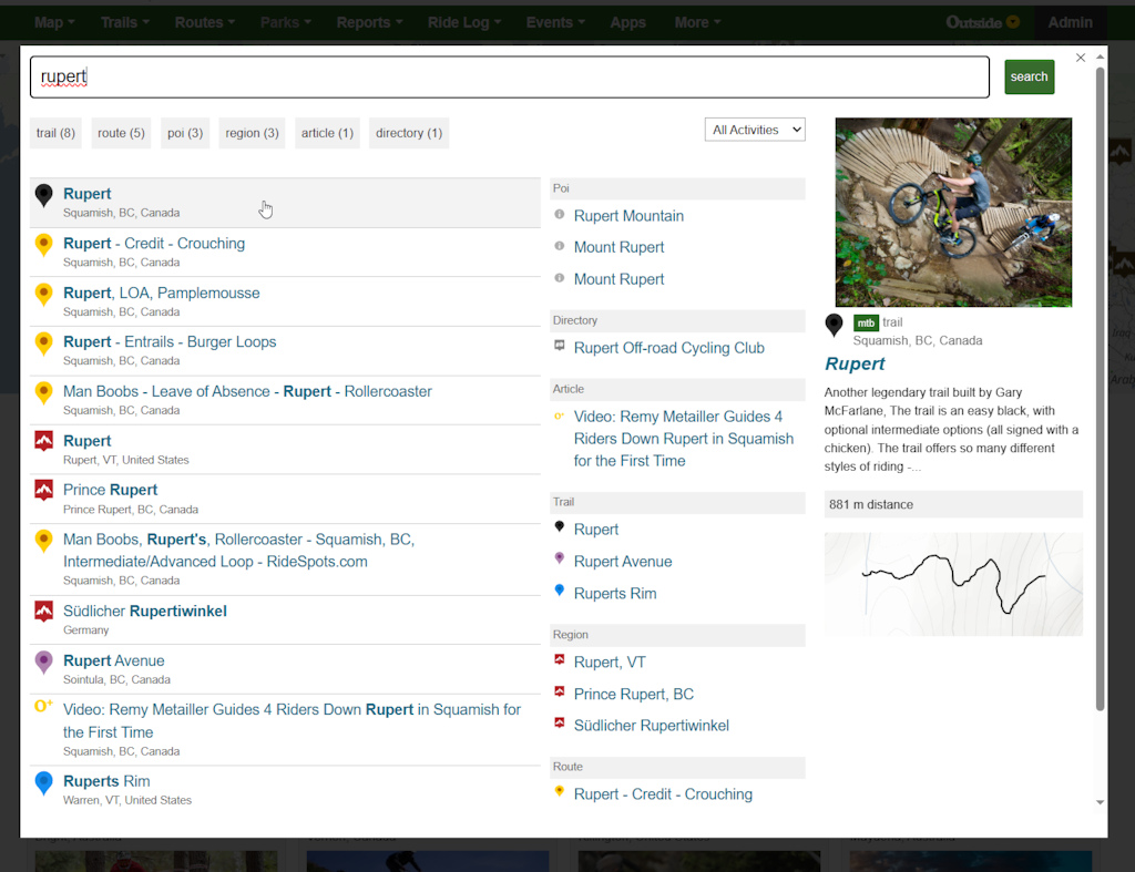
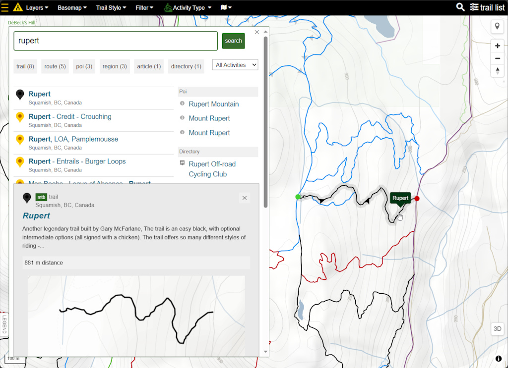
• New website search - Better & faster search, with our unique search UI, provides a great overview of results with filtering options. Search is geo-location aware, showing you nearby results or results in the context of the current map. The result: more relevant content in the search results.
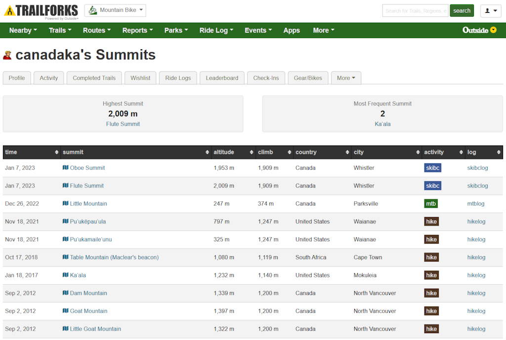
• Summit Tracker - Whether you’re on a mission to tag all 58 of Colorado’s 14,000 foot peaks, ski all the summits in your state, or tally how many times you ride your local hill, you can now keep count with the Trailforks summit Tracker.
To track summits, simply record your ride, backcountry ski tour, or adventure of choice in the Trailforks app (or on linked Garmin device). We’ll document all your summits, show how you stack up against others, and unearth new places to explore.
• Major Activity Feed improvements - A new personalized "following" feed. Follow friends, regions & trails. Many new feed items added along with new features like "high five" and share to followers. Also a new notification system to keep track of updates.
The new notifications system is much better than the old dashboard, has many more types of notifications and has a drop-down pane when clicked.
Of note, there are now new notifications for most all content related actions: issue status changes, issues assigned, content approval, content rejected, content rejected notes.
The Activity Feeds are also now viewable in the Android app for the first time. This is brand new and still under development.


• Trail Reports Map feature to visually pan around the map and view recent trail reports & conditions within the map view.

• Fullscreen Map improvements - When any map is made fullscreen, the search button will always be available and all searching will provide search results based upon the current viewable map. Clicking search results will automatically pan the map to the location, allowing the user to select the trail detail page if desired, and not automatically navigating to the trail detail page. A new quick menu has also been provided in the top left, for quick navigation to some of the more common map pages.
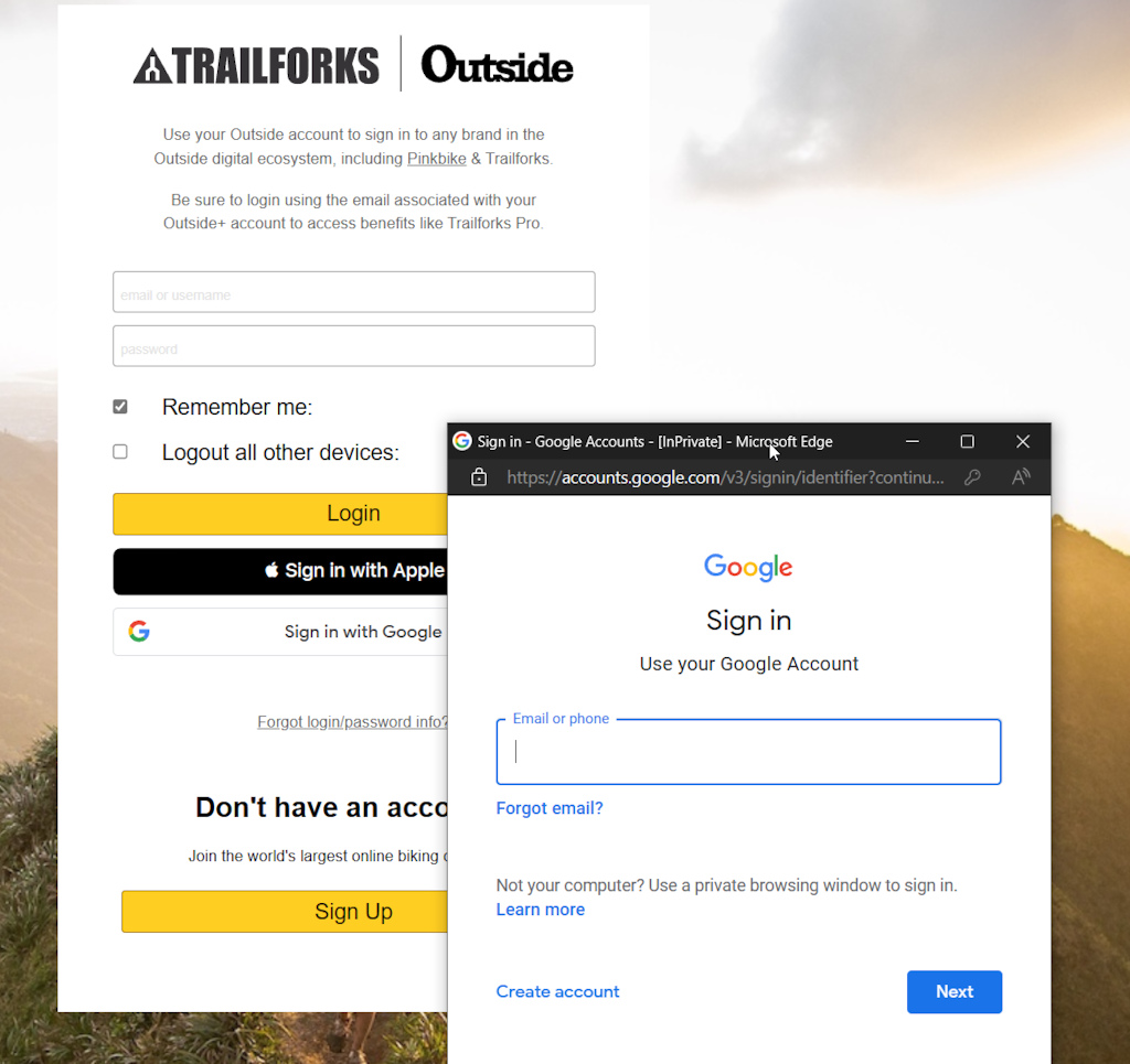
• Sign In With Google on Website & App - Faster & easier login
• Highlight Top Trails - Trailforks will periodically calculate the top 3 trails for each trail system, and highlight them automatically on the map.
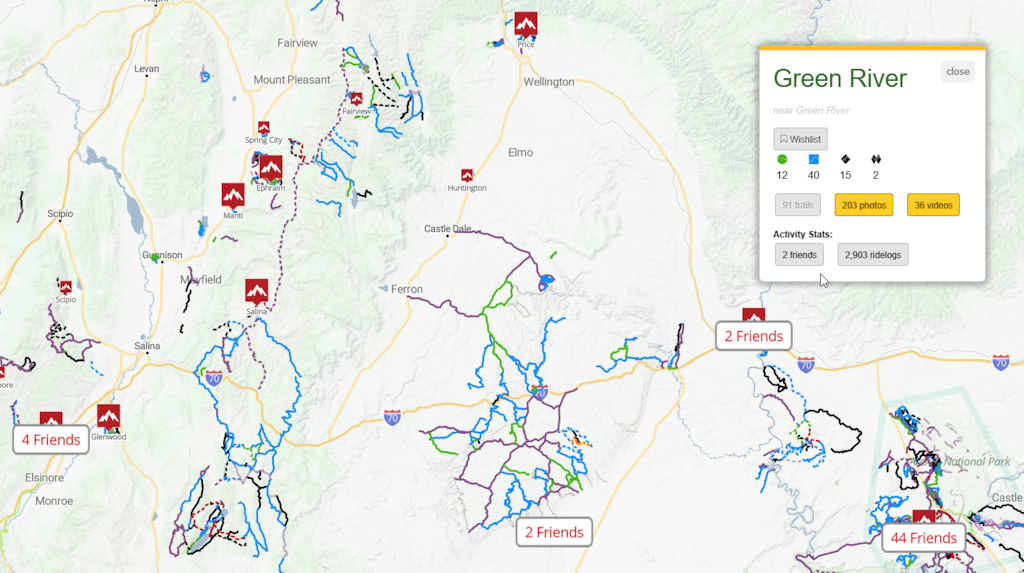
• Regions friends visited count - Periodically we analyze which regions your friends have rode. This then powers a new map layer showing these friend counts with the region markers on the map. So when you're going on a roadtrip and wondering which riding areas or towns to stop at, let your friends past activity help you decide!
• Trail Connection Route Discovery - Have you ever wanted to find a route that includes 2 or more specific trails? This is now possible with the new "Routes by Trail Finder" in the "Routes" menu. Select as many trails as you want on the map, and search for all routes that include all the selected trails.

• Follow system improvements - The activity feed now has a card that appears with follow suggestions. And you can now also follow Youtube Channels.
We also added the ability to connect your Google Contacts to help find your friends on Trailforks to follow.

• Garmin Connect integration - With the click of a button sync a route or trail you find on Trailforks to your Garmin Connect account.

• Youtube Shorts - Shorts are detected and separated to new dedicated pages. Also a Shorts Player to view MTB shorts in a stream.

• Feature tour tooltips - 6 pages now have a feature tours to help educate about the robust Trailforks features.

• Signup & login security - Much work was done improving the security checks to stop spammers and scammers along with improved moderation tools.
• Wahoo integration - Allow users to sync routes from their Trailforks account directly to the Wahoo ELEMNT Bike Computers and ELEMNT Companion App.
More Trail Association Focused Features
• Track individual workers in reports - New work tracking feature, allows trail associations to keep track of volunteer work hours, create full volunteer work reports, and export the data.

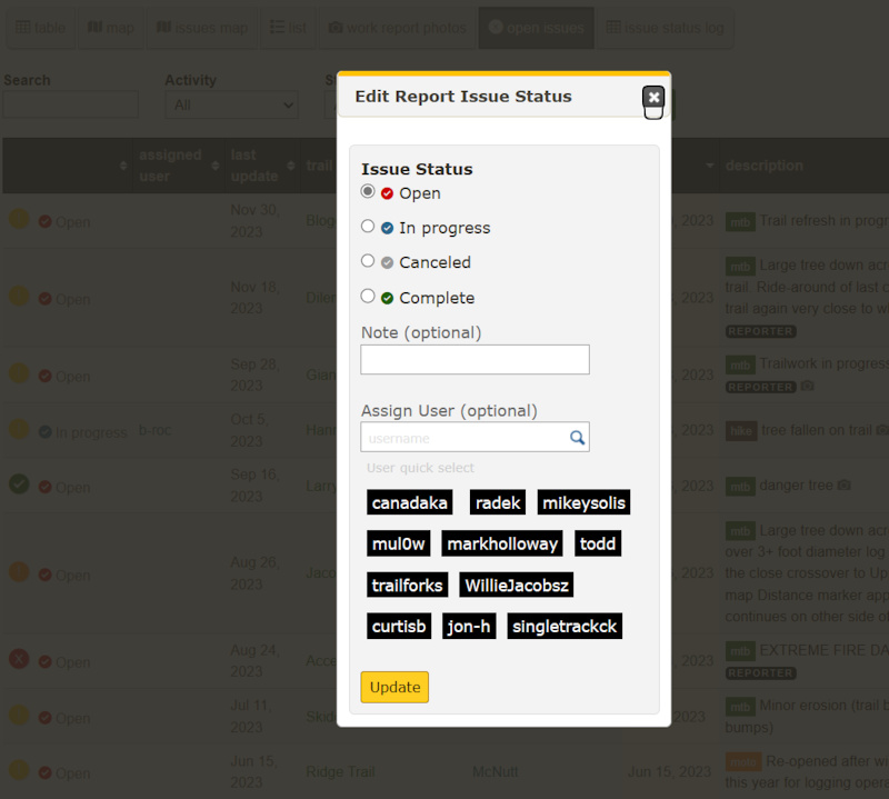
• Issue Tracking for Trail Reports - Create and assign users to a trail report. Assigned users can then provide status updates on trail issues. Administrators can manage and track issue progress via our new issue management pages.
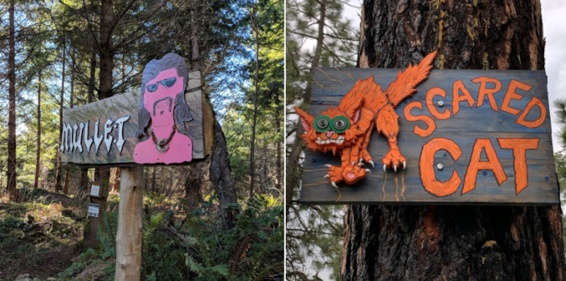
• Trail sign contest - System to submit and vote on photos for a contest. We will use this again!
• New region stats for admins - Pageview statistics for a region and the combined totals of all the content in that region. Only admins can view from a regions admin page.

• More Web
• Show Bikereg events on Trailforks events section and featured events on the map.
• Add new 'missing trails' layer to map for contributors
• Unverified trail filter
• Region trail reports, reports can be attached to a region rather than a trail
• @mention users in trail report description and comments. user receives a new notification
• Route plan widget
• POI winter/season option
• Replace many old Google maps with Mapbox
• Show Route Turn-by-turn directions on route detail page
• Set trail status to open when "planned" flag removed
• Add Gravel, Fatbike & road to Route Finder activities
• Routes layer on map hover highlight. Only show the highlighted route
• Log meters worked on in trail work report
• Save current map state when adding another trail
• Discover Map now shows videos and Outside articles
• Updated Activity Recordings layer with better data and more coverage
• Improve region markers on dense areas of the map to not clutter
• New help knowledgebase
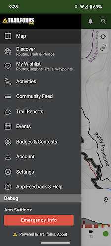
Mobile App Updates
• Rebuilt GPS Ride Recording - Ride recording has been completely redesigned to our own in-house native code. We used to rely on a 3rd party geolocation plugin. The save Ridelog form is also rebuilt along with the upload of your ride to a background task for more reliable & faster activity saving.

• Mapbox 10 Upgrade & 3D maps - This was a major code change to migrate to this new version of our mapping framework. It did bring some cool new features like 3D maps to the app.

• Rebuilt Navigation UI for Android - The entire navigation UI including header, tabs, menu, map sheets and bars is new on Android. These new developments provide a smoother user experience and sets up a better foundation to build new app features going into the future.
• Optimized background data syncing - Downloading of regions is much faster & reliable now and happens in the background, even if the app is not active. Same goes for syncing of all other data, moved to background tasks. The settings and sync screens have also been rebuilt. This might not sound like a fancy new feature, but its major re-architecture work that improves the basic functions of the app. Maintaining our commitment to have as much of the app work offline as possible.

• App tooltips - We built a framework to start adding tooltips to educate users on features of the app. We've added a couple tooltips to start with more coming in the future.

• Waypoints - Last year we added personal Waypoints to the website. Now these customizable waypoints are synced to both the Android and iOS apps. You can also add and edit waypoints in the app.

More App
• Trails with a "Closed" trail status show as faint on the map
• Do not show trail name label layer on areas which have not been downloaded yet. To reduce some user confusion with trails not on the map.
• Improve the cold boot speed of the app on Android.
• Option in settings to manually toggle dark mode separate from OS default. More screens in the app are getting dark mode support over time.
• Fixes to the Discover screen
• More checks and warnings if a user try's to record their ride with battery saving modes enabled
• Private toggle on trail reports
• Native photo view with zoom
• Fix deeplinks
• Flaky & inconsistent location compass mode fixed
• Refactored login & signup screen with Google & Apple login
• Show photos on POI detail page
• Rebuilt settings screens
• View your notifications and message inbox in the app
• Gaia Topo Basemap
Coming Soon to The App
• Traildar - Proximity alerts on the map. Place a Traildar point on the map at an intersection or point of interest. Then as you ride get audio and haptic feedback when you near that point.

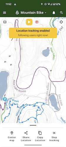
• Basic Location Sharing - This has been a long time coming and is just the first step. Share your location with a friend via a link. Open the link in the app to view the location or on the website and watch it auto-update. The early version of this is already rolling out in Beta on Android.
Trailforks Platform
Health of the platform is strong as Trailforks website & app usage continue to grow. Contributions by our amazing community of local admins, ambassadors and power users remained strong in 2023. We also added over 40k trails from staff this year.
We recently have on-boarded more dedicated customer support and have hired another community & social manager. We are growing the development team as well.
We also soft launched an affiliate program for trail associations.
We have a lot of exciting things coming in 2024. As we've been laying the foundations through app-refactoring, we are now able to focus more on adding new features.
If you are with a trail association and want to learn more about the benefits of Trailforks, click here.
Thank you to our users for their continued support whether it's being a Trailforks Pro subscriber, a contributor of content to the map, or just a regular user contributing ridelogs and trail reports.
Happy Trails
Author Info:

Must Read This Week
Sign Up for the Pinkbike Newsletter - All the Biggest, Most Interesting Stories in your Inbox
PB Newsletter Signup
I don't like admitting that to tech companies normally, because it generally leads to extortion, but I trust @canadaka and crew as they have been very fair and very generous over the many years.
I use TF as a software design example to clients. It ain't perfect, but it is built with the user in mind, and gets better all the time. All you can ask for.
Keep up the great work gang. And please don't let the capitalists make you extort us
(Which might become irrelevant in Germany anyway, as the use of all these apps might become illegal for mountainbiking.)
Maybe some people never, ever, ride anything but their home trails?
strava: UX is total shite IHO. I still have strava but i guess it's because of "historical reasons" because strava used to be a great solutions but trailforks definately overtook
komoot: lack of trails and contributions from users. more targeted for touring than for biking
with this newest update TF sets itself even more in front than ever. i even think it's time to get rid off strava completely because lack of USP.
all in all: WOW @canadaka those updates really are top! Happy you guys exist and happy to pay for your service!
By law, recreation is currently a core function of our forests. The draft wants to change recreation into an optional function.
The reasons for these changes boil down to financial incentives for the landowner, environmental protection and the age old debate of landowners vs. right of way.
Not to get too political here but exactly why we should all be concerned about things that limit our freedoms. There's always a reason/excuse that ends up restricting some people at the request of others. You can just rewind two years and see how quickly access was cut off to public places in the name of "health." As a rider, I hope the future isn't more narrow minded and bureaucratic trail "management."
Also, and this isn’t Trailforks issue but most of trails in my home area aren’t on Trailforks so it’s most beneficial traveling outside of that small rectangle to areas that have legal trails. I’m def not going to contribute reports to trails I can’t even see in the app.
A lot of the trails making up that 300k are access roads, connectors & such. It will vary region to region, some will be very active, some almost nothing. But Trailforks platform has more trail report volume than competitors and other features to assist in figuring our trail conditions. No app is going to have consistent high volume globally.
There is a lot of features related to trail reporting: www.trailforks.com/about/features/trail_reporting
All I can say is that in 2023 the most trail reports have been added at over 610,000 in one year.
We did however start to launch an affiliate program for trail associations. Where they recurring cut of the subscription and the user gets bit of a discount as well. We launched it too late this year to hit membership drives. So it should see more usage this next season.
The moment you guys hide one rogue heat map in our town, then I’ll believe you. Two years later and I’m still calling BS.
Infortunately, when you jump through all their hoops, they don’t do anything and the trails remain on heatmap.
Except you ghost people who reach out get help trying to get sensitive trails off the heat map...
We try our best to create automated systems for flagging and removing sensitive trails from the heatmap. And create lots of self serve methods for admins to help. But it's always an imperfect system, matching GPS is never perfect. updating world wide heatmaps in a timely manor is hard. But we still try, this is something that our competitors do not do. We don't have to do any of this, we could just use OSM data and be done with it, everything shown, like all other apps.
"secret" trails in the middle of a popular trail network are never going to stay offline, those days are long gone. The trails in question are lit up on Strava.
But I will say that at the end of the summer we onboarded 2 new support people for Trailforks and just hired a new Community & Social manager. So now our responsiveness to support inquiries will be much better than it has been.
If it's on TF a trail is more likely to be ridden by more people. Sometimes when a trail is built its nice to have it found simply by people looking, or by word of mouth or (my fav) being shown by the builder.
Having said that, In this day and age, a trail will inevitably get added on to OSM or some heat map etc. What a builder might try to do is buy the trail a year or two of quiet time by keeping the numbers low for that time period. It doesn't mean others are forbidden from riding it. It may simply just mean that people discovering the trail get the joy and wonder of finding it the "old-fashioned" way of human discovery.
Hope this makes sense
I always try to keep the view that one should keep expectations low so as to not be disappointed. Thank you for being a good example of why that's a good view to take
She’s still not back and I’m having too good a time to report her missing.
Thanks Dev Team!
⭐️⭐️⭐️⭐️⭐️
They call this "capitalism" now, I call this bait and switch, and apologizing this kind of behaviour is immoral at best and I hope one day even illegal.
There was no plan from the beginning. Circumstances, intentions and business needs change.
Trailforks has always offered free ways to still access any data contributed.
With the rate of growth that you had, I'm sure you knew many months in advance when you were going to start charging for it, and you could have been transparent about it and just said it that many months in advance. I genuinely doubt that you went into a serious project like this without any consideration about current and future costs and no plans how to solve those. You could have been at least sincere and said: "hey guys we might put this behind paywall, or accept donations in the future, but you're welcome to add your contributions" and nobody could take offense on that. The uptake might have been slower, but at least people would know what to expect. But pretending to be a underdog, while vacuuming trails from user's strava accounts, and worst of all; having people spend many hours drawing trails, and then later locking those in a vault seems disreputable.
In the end your intentions might have been pure, but this is still a classic bait and switch, and really left a sour taste for any further contribution in any kind of grass roots software. Tempi passati as Italians would say.
I also use those same open source libraries to make money with code and data that I don’t share with the world. And a lot of that data I compiled from free sources. But that doesn’t mean that my time with clients is free.
But the open source mode doesn’t apply here. Paying good software developers to develop good software doesn’t run on hopes and dreams and wishes. It costs money. I don’t care how big your pile of data is. It’s worthless without a good and reliably available interface.
All of the freely-shared data is still freely available on the website. Only access via the mobile app costs money.
I paid for the app, because I *really* want Trailforks to continue.
But I rarely use the app. I’d guess 90% of my usage is browsing on the web, planning a route, and then sending that to my GPS head unit. That’s free for everyone.
But if you can make a mobile app for free, tell me where to email my data and I’ll send it to you.
1) Pre-ride planning - Need to know trail conditions. I would like to encourage more users to report trail conditions. Maybe a quick, post-ride "How were trail conditions?" survey to get more accurate data? Something as simple as 1-5 scale where 1 should be avoided at all costs and 5 being perfect. It seems like the best way to get updates is on Facebook groups, but that's another good bit of navigating and searching for specifics....
2) Leading a pack and need to quickly verify location/path. Having Traildar is genius!
3) Checking how much more distance/elevation from existing location to end of climb/descent. A calculated amount based on trail location would be sweet!
You can determine likely conditions a lot of other ways than reports on Trailforks as well. This blog posts explains a bit more www.trailforks.com/blog/view/trailforks-update-shoulder-season-trail-condition-features
For #3, this is not something Trailforks currently does, it would involve following a planned route. However through our partnership with Garmin you can get this feature on Garmin Edge devices. if you follow a route on the Garmin, it auto-determines some of the climbs and shows you a special climb display.
One problem with these apps is that users have no idea what they're actually giving up, because the companies mine the data on their own and don't share the insights with users.
Any data scientist worth even entry level money can tell you what the trail conditions were on a given day by looking at the usual speed of a cyclist and comparing that to the day's conditions, over the dataset of everyone who rode that day. Muddy trails slow people down in an identifiable way, ice slows people down in an identifiable way, rain slows people down in an identifiable way. Even a junior data scientist can also fingerprint any type of trail hazard just from GPS uploads. The accelerometers in a modern cell phone can tell from your gait when you're tired or have an injured ankle, they sure as heck can tell when you stop your bike get off and jump over a log.
They're hiding all this data mining from you, but I assure you they know EVERYTHING. They just haven't figured out how to monetize it yet.
Edit: A modern cell phone can fingerprint the person whose pocket it is in just by fingerprinting their walking gait, which is as unique as a fingerprint:
www.sciencedirect.com/science/article/pii/S0167404821003813
The power of the sensing is a thousand times greater than the power of humans to understand what's being sensed. And the data sits forever in the data warehouses, yielding new insights as AI gets smarter and people don't.
TF is better than it ever has been. It’s worth the price to have this service. I use it daily.
I’d really like to see TF do a yearly donation drive for local trail orgs. The trail karma thing has done good for us at EMBA and the JGulch crew. Pairing a donation drive with a contest to win TF pro or something else from a generous donor would be a great thing.
Thanks for what you do!
Very poor beta testing of the upgrade, needs alot of work to get it back to where it was (i.e. usable!!)
We've got a load of trails that have been closed through storm damage (for years) - in some forests the trails have been marked as 'Closed', so appear as greyed out and dashed lines. On other areas, the trails remain visible, even though successive reports have people saying that the trail is closed, dangerous etc.
What's the process here?
If you are an active local user (seems like that from your user profile on TF) and want to get more done, then get involved, contact with your local Trail Association, check who is the region admin (scroll all the way down on the region main tab to see it), edit the content your self, add trails that are missing.
This is the local trail association, that you actually donated some Karma to them:
www.trailforks.com/directory/12269
1) Search function just does not work - I can find a trail on Trailforks website, but whenn I type in the exact name in the app, it doesn't appear at all.
2) Using Trailforks in UK is pointless - very outdated trails, app does not include new trails (in trails centers), does not shows trails as closed etc.
Waste of money unfortunately, tried using it 3-4 times and gave up. Maybe in the US/Canada it works well
It would be better if you could only add a trail if you've actually visited the area and been on that trail - like from a Ridelog. I think people are adding based on old OSM data.
That said, I enjoy using TF and I contribute frequently.
A screen recording video would be worth a 1000 words.
Any chance you'll be developing the Garmin app for the newer larger screen watches like the Epix Pro Gen 2 with 51mm screen? I was hoping it would come out before touring season.
Is it possible to change the function of viewing routes.
Currently you go to a trail and go to the routes “tab” and click to view a route, then you have to go back to view the next route in the list.
It seems intuitive to me that I would be able to swipe right or left to view the next route from the list.
This is badass TF. You should be as proud as proud can be.
We have managed to keep the website open and mostly free, even without an account. This is not true for our largest competitors now. We are making some changes to free access in the app this month. Something i've been advocating for and Outside has agreed to. Free users will have basic access to the map and location for a much larger area.
Wait, really? Free users will have a larger map area?
Finally!
Among other existential things, that was one of my main annoyances once they changed from free to paid. The free area was pretty small. Like, "choose which one of the two biggest trail networks within an hour of your house you want maps for" small. So any change there would be great.
I re-read the article from 2020, and yes it outlines a number of the free benefits in Trailforks. I can't say as I agree with all of the statements made in that piece. And sure, this is a capitalist system but it was the way things were initially sold as a community project that turned around to charge the very people who provided the data for their own contributions. The article says itself, it was a full-time job just responding to all of the people who were disgruntled by the move.. there's something in that. I feel foolish for believing at one point this was a community project, I'm guessing others do as well. I noticed that the comments for the article you linked were turned off.
I'm glad that subscribers find great benefit to the platform, and hope it makes their riding experiences better. I for one, won't pay for it on principle alone.
I don't use Trailforks, so why would I have any 'points'? Shocker - Trailforks is not the only way which people contribute to their biking community. You don't know me. I am integrated into mine and therefore rub up against users and organizers who do use it, and have beef.
Nothing changes the facts here: trail networks are primarily community focused (public interests/builders/maintainers/users) and partly business (primarily tourism). At least with tourism, the local community benefits from jobs and income. Trailforks came in under the guise of 100% community, got a ton of community groundwork to gain enough traction and then cleaved off a sizeable component behind a paywall. Here's your free bits, thanks for the private business. Read the comments in every article on this, LOTS of people feel the same.
Ofc TF is not the only way people contribute, but we are talking here about TF, not other tools or platforms. And focused on TF, the only way to see if a user is involved and contributing to the platform is checking its profile and his activity. I can't say anything else about you or anyone else that is not in there. I don't know who you are and what you do or don't do, all I can see is that you have not added content to the platform and therefore you are not part of the community that volutarly contributes to help the platform grow.
Please refrain from the unneccesary ad hominem arguments.
Why not offer a one time fee that gives the simple format of just trails, GPS and Emergency for a simple fee of just $20.
Maybe He came to just read comments and find others with the same feelings .
Would really like to ditch Strava
Give it a chance, even if it's just to give your opinion. ;p
www.trailforks.com/ridelog/view/58134429/tour
maybe I just think too much :'D
Should read:
"But first, three big milestones you all have recently hit."
Credit where it's due, no need to get all bent up over it.
But us Trailforks staff are part of the community as well and contribute a lot of content, we are the top contributors.
And I’m hardly bent out of shape if I’m making Hair Club for Men references